Search results
Jump to navigation
Jump to search
Page title matches
- |category4=Soil |tree1=Jules Soil3 KB (435 words) - 20:36, 12 January 2017
- |tree2=Little Bear Soil The Little Bear Soil (Mellen, 1937, p. 8-20), a soil locally preserved at the base of the Cretaceous System, is named for Little2 KB (272 words) - 21:43, 23 November 2016
- |tree1=Modern Soil This unit has long been called "Modern Soil," and it seems undesirable to replace it with a geographic name.2 KB (266 words) - 21:10, 6 September 2022
- |tree1=Modern Soil This unit has long been called "Modern Soil," and it seems undesirable to replace it with a geographic name.1 KB (206 words) - 05:22, 28 December 2016
- |tree2=Little Bear Soil The Little Bear Soil (Mellen, 1937, p. 8-20), a soil locally preserved at the base of the Cretaceous System.3 KB (345 words) - 16:36, 11 January 2017
- |tree1=Jules Soil |category4=Soil2 KB (366 words) - 06:42, 28 December 2016
- |category4=Soil |tree1=Afton Soil6 KB (858 words) - 17:09, 4 January 2017
- |tree1=Sangamon Soil |category4=Soil10 KB (1,487 words) - 22:23, 3 January 2017
- |category4=Soil |tree1=Yarmouth Soil8 KB (1,197 words) - 22:33, 12 January 2017
- |tree1=Chapin Soil |category4=Soil3 KB (492 words) - 22:23, 3 January 2017
- |category4=Soil |tree1=Pike Soil4 KB (661 words) - 22:26, 12 January 2017
- |category4=Soil |tree1=Sangamon Soil10 KB (1,550 words) - 21:13, 12 January 2017
- |tree1=Farmdale Soil |category4=Soil7 KB (991 words) - 22:20, 3 January 2017
- |category4=Soil |tree1=Chapin Soil4 KB (556 words) - 20:59, 12 January 2017
- |tree1=Afton Soil |category4=Soil5 KB (797 words) - 16:19, 4 January 2017
- |tree1=Yarmouth Soil |category4=Soil7 KB (1,133 words) - 22:43, 3 January 2017
- |category4=Soil |tree1=Farmdale Soil7 KB (1,054 words) - 20:38, 12 January 2017
- |tree1=Pike Soil |category4=Soil4 KB (591 words) - 22:14, 3 January 2017
- |tree1=Pleasant Grove Soil |category4=Soil3 KB (410 words) - 22:22, 3 January 2017
- |category4=Soil |tree1=Pleasant Grove Soil3 KB (477 words) - 20:46, 12 January 2017
Page text matches
File:Figure Q-1E.jpg ..., Sangamon Soil developed in the Illinoian Loveland Silt (SL) and Yarmouth Soil developed in till of the Kansan Banner Formation (YB); in a roadcut at Inde(2,000 × 1,529 (1.16 MB)) - 13:11, 5 April 2016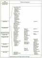
File:104-Figure 1 2.jpg Soil Stratigraphy(1,445 × 2,000 (307 KB)) - 15:47, 19 April 2016- |tree1=Modern Soil This unit has long been called "Modern Soil," and it seems undesirable to replace it with a geographic name.1 KB (206 words) - 05:22, 28 December 2016
- #REDIRECT [[Little Bear Soil ]]31 bytes (4 words) - 13:47, 29 April 2016
- |tree1=Chapin Soil |category4=Soil3 KB (492 words) - 22:23, 3 January 2017
- |tree1=Pleasant Grove Soil |category4=Soil3 KB (410 words) - 22:22, 3 January 2017
- |tree2=Little Bear Soil The Little Bear Soil (Mellen, 1937, p. 8-20), a soil locally preserved at the base of the Cretaceous System, is named for Little2 KB (272 words) - 21:43, 23 November 2016
- |tree1=Jules Soil |category4=Soil2 KB (366 words) - 06:42, 28 December 2016
- |tree1=Pike Soil |category4=Soil4 KB (591 words) - 22:14, 3 January 2017
- |tree1=Modern Soil This unit has long been called "Modern Soil," and it seems undesirable to replace it with a geographic name.2 KB (266 words) - 21:10, 6 September 2022
- |category4=Soil |tree1=Chapin Soil4 KB (556 words) - 20:59, 12 January 2017
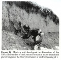
File:104-Figure 26.jpg Figure 26 -- Modern soil developed in diamicton of the Yorkville Member of the Lemont Formation abov(2,000 × 1,964 (1.29 MB)) - 17:19, 19 April 2016- |category4=Soil |tree1=Pleasant Grove Soil3 KB (477 words) - 20:46, 12 January 2017
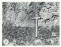
File:Figure Q-1F.jpg ...rkness Silt Member of the Kansan Banner Formation (Bh) overlying the Afton Soil developed on gravel of the Nebraskan Enion Formation (AE); in a roadcut at(2,000 × 1,529 (1.13 MB)) - 19:04, 22 April 2016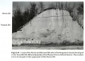
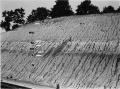
File:104-Figure 29.jpg ...e Silt (Illinois Episode) at the Pleasant Grove School Section. The modern soil is developed in the upper part of the Peoria Silt.(2,000 × 1,458 (1,015 KB)) - 17:50, 19 April 2016- |category4=Soil |tree1=Pike Soil4 KB (661 words) - 22:26, 12 January 2017
- |category4=Soil |tree1=Jules Soil3 KB (435 words) - 20:36, 12 January 2017
- |tree1=Afton Soil |category4=Soil5 KB (797 words) - 16:19, 4 January 2017
- |tree2=Little Bear Soil The Little Bear Soil (Mellen, 1937, p. 8-20), a soil locally preserved at the base of the Cretaceous System.3 KB (345 words) - 16:36, 11 January 2017
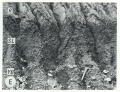
File:Figure Q-1A.jpg ...tion (Wd), Morton Loess(M), Robein and Roxana Silts (RR), and the Sangamon Soil (S) on till of the Illinoian Glasford Formation(G); in a railroad cut a mil(2,000 × 1,487 (735 KB)) - 16:04, 5 April 2016- |tree1=Farmdale Soil |category4=Soil7 KB (991 words) - 22:20, 3 January 2017
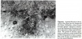
File:104-Figure 21.jpg ...emont Formation. The gamma B horizon represents an extension of the modern soil profile along joints to form a secondary zone of clay accumulation below th(2,000 × 956 (702 KB)) - 17:04, 19 April 2016- ...se sections contain the type localities for 21 rock-stratigraphic units, 4 soil-stratigraphic units, and 3 time-stratigraphic units and include paratypes f ...age of Illinoian Stage), and its upper boundary is the top of the Sangamon Soil, developed in the silts; it is overlain by the Roxana Silt. The term is not3 KB (495 words) - 22:26, 3 January 2017
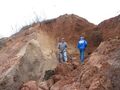
File:Fig 0870 Photos 002.JPG ...nois. Pictured are David Grimley (ISGS) left and Gerry Berning (USDA-NRCS, Soil Scientist) on the right, for scale. Sangamon Geosol development is visible(2,272 × 1,704 (1.15 MB)) - 22:06, 15 September 2022- |category4=Soil |tree1=Afton Soil6 KB (858 words) - 17:09, 4 January 2017
- |category4=Soil |tree1=Farmdale Soil7 KB (1,054 words) - 20:38, 12 January 2017
- |tree1=Yarmouth Soil |category4=Soil7 KB (1,133 words) - 22:43, 3 January 2017
- ...se sections contain the type localities for 21 rock-stratigraphic units, 4 soil-stratigraphic units, and 3 time-stratigraphic units and include paratypes f ...verlies the Chapin Soil and is terminated at the top by the Pleasant Grove Soil and the overlying Meadow Loess Member of the Roxana Silt.<br>4 KB (518 words) - 22:21, 3 January 2017
- ...se sections contain the type localities for 21 rock-stratigraphic units, 4 soil-stratigraphic units, and 3 time-stratigraphic units and include paratypes f ..., gray silt and fine sand at the top, overlying a weakly developed unnamed soil in the top of sand and gravel outwash, which in turn unconformably overlies4 KB (592 words) - 22:26, 3 January 2017
- |category4=Soil |tree1=Yarmouth Soil8 KB (1,197 words) - 22:33, 12 January 2017
- |tree1=Sangamon Soil |category4=Soil10 KB (1,487 words) - 22:23, 3 January 2017
- ...se sections contain the type localities for 21 rock-stratigraphic units, 4 soil-stratigraphic units, and 3 time-stratigraphic units and include paratypes f ...age of Illinoian Stage), and its upper boundary is the top of the Sangamon Soil, developed in the silts; it is overlain by the Roxana Silt. The term is not4 KB (562 words) - 21:57, 12 January 2017
- |category4=Soil |tree1=Sangamon Soil10 KB (1,550 words) - 21:13, 12 January 2017
- ...se sections contain the type localities for 21 rock-stratigraphic units, 4 soil-stratigraphic units, and 3 time-stratigraphic units and include paratypes f ...osition is commonly indistinguishable from that of the underlying Sangamon Soil B-zone. Other stratigraphic sections with this report describing the Markha5 KB (755 words) - 15:47, 18 November 2016
- ...se sections contain the type localities for 21 rock-stratigraphic units, 4 soil-stratigraphic units, and 3 time-stratigraphic units and include paratypes f ...verlies the Chapin Soil and is terminated at the top by the Pleasant Grove Soil and the overlying Meadow Loess Member of the Roxana Silt.<br>4 KB (584 words) - 20:46, 12 January 2017
- ...e Winslow Till is commonly bounded at the base by bedrock or by a residual soil developed in bedrock.2 KB (347 words) - 22:28, 3 January 2017
- ...se sections contain the type localities for 21 rock-stratigraphic units, 4 soil-stratigraphic units, and 3 time-stratigraphic units and include paratypes f ...ped in McDonough Loess and is terminated upward by the top of the Farmdale Soil or by the Robein Silt, Morton Loess, or Peoria Loess.4 KB (579 words) - 22:20, 3 January 2017
- ...rville Till Member, but more commonly it rests on bedrock or on a residual soil developed in bedrock. Further subdivision of the Ogle Member would appear t3 KB (413 words) - 22:27, 3 January 2017
- ...se sections contain the type localities for 21 rock-stratigraphic units, 4 soil-stratigraphic units, and 3 time-stratigraphic units and include paratypes f ..., gray silt and fine sand at the top, overlying a weakly developed unnamed soil in the top of sand and gravel outwash, which in turn unconformably overlies5 KB (658 words) - 22:01, 12 January 2017
- ...se sections contain the type localities for 21 rock-stratigraphic units, 4 soil-stratigraphic units, and 3 time-stratigraphic units and include paratypes f ...he top of the Yarmouth Soil and the upper boundary the top of the Sangamon Soil. The Loveland Silt is classified here as a formation.<br>6 KB (856 words) - 22:23, 3 January 2017
- ...se sections contain the type localities for 21 rock-stratigraphic units, 4 soil-stratigraphic units, and 3 time-stratigraphic units and include paratypes f ...e, by the top of the Yarmouth Soil. Its upper limit is the top of the Pike Soil (New Salem Northeast, Pleasant Grove Sections, table 6), the Duncan Mills M5 KB (773 words) - 22:14, 3 January 2017
- ...se sections contain the type localities for 21 rock-stratigraphic units, 4 soil-stratigraphic units, and 3 time-stratigraphic units and include paratypes f ...t was intermittently wet, and the entire deposit is considered an accreted soil.4 KB (578 words) - 22:48, 3 January 2017
- ...se sections contain the type localities for 21 rock-stratigraphic units, 4 soil-stratigraphic units, and 3 time-stratigraphic units and include paratypes f ...e section the Radnor Till is bounded at the top by the top of the Sangamon Soil. It is overlain by Roxana Silt and it rests on the Toulon Member. The Radno3 KB (472 words) - 22:26, 3 January 2017
- ...esence of the Sangamon Soil in the top of the Pearl, or, when the Sangamon Soil is missing, the presence of the Roxana Silt above the Pearl. <br> It consists of sand and gravel that has the Sangamon Soil in its top. It overlies Illinoian or older drift or bedrock. <br>4 KB (622 words) - 22:26, 3 January 2017
- ...se sections contain the type localities for 21 rock-stratigraphic units, 4 soil-stratigraphic units, and 3 time-stratigraphic units and include paratypes f ...osition is commonly indistinguishable from that of the underlying Sangamon Soil B-zone. Other stratigraphic sections with this report describing the Markha6 KB (818 words) - 21:04, 12 January 2017
- ...se sections contain the type localities for 21 rock-stratigraphic units, 4 soil-stratigraphic units, and 3 time-stratigraphic units and include paratypes f It rests on the Afton Soil developed in outwash and it is overlain by till of the Banner Formation of3 KB (489 words) - 16:09, 4 January 2017
- ...se sections contain the type localities for 21 rock-stratigraphic units, 4 soil-stratigraphic units, and 3 time-stratigraphic units and include paratypes f ...he top of the Yarmouth Soil and the upper boundary the top of the Sangamon Soil. The Loveland Silt is classified here as a formation.<br>6 KB (911 words) - 21:17, 12 January 2017
- ...se sections contain the type localities for 21 rock-stratigraphic units, 4 soil-stratigraphic units, and 3 time-stratigraphic units and include paratypes f ...ped in McDonough Loess and is terminated upward by the top of the Farmdale Soil or by the Robein Silt, Morton Loess, or Peoria Loess.5 KB (644 words) - 20:41, 12 January 2017
- ...se sections contain the type localities for 21 rock-stratigraphic units, 4 soil-stratigraphic units, and 3 time-stratigraphic units and include paratypes f ...e, by the top of the Yarmouth Soil. Its upper limit is the top of the Pike Soil (New Salem Northeast, Pleasant Grove Sections, table 6), the Duncan Mills M6 KB (833 words) - 22:28, 12 January 2017
- ...se sections contain the type localities for 21 rock-stratigraphic units, 4 soil-stratigraphic units, and 3 time-stratigraphic units and include paratypes f The silt rests on the Yarmouth Soil and is overlain by till of the Glasford Formation of Illinoian age. <br>4 KB (520 words) - 22:41, 3 January 2017
- ...se sections contain the type localities for 21 rock-stratigraphic units, 4 soil-stratigraphic units, and 3 time-stratigraphic units and include paratypes f ...t was intermittently wet, and the entire deposit is considered an accreted soil.4 KB (637 words) - 22:35, 12 January 2017
- ...e Winslow Till is commonly bounded at the base by bedrock or by a residual soil developed in bedrock.3 KB (414 words) - 22:03, 12 January 2017
- ...n accreted soil, the Berry Clay Member is included as part of the Sangamon Soil. The Berry Clay Member may overlie the Sterling, Radnor, Hulick, Vandalia,3 KB (484 words) - 22:23, 3 January 2017
- ...se sections contain the type localities for 21 rock-stratigraphic units, 4 soil-stratigraphic units, and 3 time-stratigraphic units and include paratypes f ...se sections contain the type localities for 21 rock-stratigraphic units, 4 soil-stratigraphic units, and 3 time-stratigraphic units and include paratypes f11 KB (1,564 words) - 22:23, 3 January 2017
- ...se sections contain the type localities for 21 rock-stratigraphic units, 4 soil-stratigraphic units, and 3 time-stratigraphic units and include paratypes f ..., or Pearl Formation; locally, in the absence of these units, the Sangamon Soil is developed in the top of the member. The Hulick is in part stratigraphica4 KB (614 words) - 22:26, 3 January 2017
- ...esence of the Sangamon Soil in the top of the Pearl, or, when the Sangamon Soil is missing, the presence of the Roxana Silt above the Pearl. <br> It consists of sand and gravel that has the Sangamon Soil in its top. It overlies Illinoian or older drift or bedrock. <br>5 KB (688 words) - 21:57, 12 January 2017
- ...rville Till Member, but more commonly it rests on bedrock or on a residual soil developed in bedrock. Further subdivision of the Ogle Member would appear t3 KB (488 words) - 22:08, 12 January 2017
- ...re than 4 to 6 feet thick in the northern part, it is calcareous below the soil. The calcareous loess locally contains fossil snail shells (Leonard and Fry The unit consists of yellow-tan massive loess and contains the Modern Soil in the top. The Richland Loess has been described by Willman and Payne (1946 KB (860 words) - 05:31, 28 December 2016
- ...s overlain by 1 to 2 feet of leached brown silt (Richland Loess and Modern Soil).2 KB (241 words) - 05:39, 28 December 2016
- ...se sections contain the type localities for 21 rock-stratigraphic units, 4 soil-stratigraphic units, and 3 time-stratigraphic units and include paratypes f ...e section the Radnor Till is bounded at the top by the top of the Sangamon Soil. It is overlain by Roxana Silt and it rests on the Toulon Member. The Radno4 KB (539 words) - 21:59, 12 January 2017
- ...se sections contain the type localities for 21 rock-stratigraphic units, 4 soil-stratigraphic units, and 3 time-stratigraphic units and include paratypes f ...se sections contain the type localities for 21 rock-stratigraphic units, 4 soil-stratigraphic units, and 3 time-stratigraphic units and include paratypes f11 KB (1,623 words) - 21:14, 12 January 2017
- ...se sections contain the type localities for 21 rock-stratigraphic units, 4 soil-stratigraphic units, and 3 time-stratigraphic units and include paratypes f It rests on the Afton Soil developed in outwash and it is overlain by till of the Banner Formation of4 KB (549 words) - 22:40, 12 January 2017
- ...glacial deposits bounded by the Farmdale Soil at the top and the Sangamon Soil at the base.<br>5 KB (697 words) - 20:55, 12 January 2017
- ...egional continuity of many of the stratigraphic units. The loesses and the soil-stratigraphic units have the greatest regional continuity, although some of ...chart in figure Q-4 shows all time-stratigraphic, rock-stratigraphic, and soil-stratigraphic terms currently in use in Illinois and this report. The surfa14 KB (2,141 words) - 16:42, 10 January 2017
- ...se sections contain the type localities for 21 rock-stratigraphic units, 4 soil-stratigraphic units, and 3 time-stratigraphic units and include paratypes f ...s occurring below the base of the Banner Formation or the top of the Afton Soil; it overlies bedrock formations or the Grover Gravel.4 KB (650 words) - 16:23, 4 January 2017
- ...r lies stratigraphically above the Vandalia Till and contains the Sangamon Soil at the top. It is commonly overlain by Wisconsinan loesses.2 KB (243 words) - 22:26, 3 January 2017
- ...se sections contain the type localities for 21 rock-stratigraphic units, 4 soil-stratigraphic units, and 3 time-stratigraphic units and include paratypes f ...se sections contain the type localities for 21 rock-stratigraphic units, 4 soil-stratigraphic units, and 3 time-stratigraphic units and include paratypes f10 KB (1,522 words) - 22:46, 3 January 2017
- ...LMER, R. E. HUGHES, and P. A. SOLHEID, 2003, Modern, Sangamon and Yarmouth soil development in loess of unglaciated southwestern Illinois: Quaternary Scien1 KB (136 words) - 21:55, 2 March 2018
- ...LMER, R. E. HUGHES, and P. A. SOLHEID, 2003, Modern, Sangamon and Yarmouth soil development in loess of unglaciated southwestern Illinois: Quaternary Scien1 KB (136 words) - 21:09, 22 December 2016
- ...se sections contain the type localities for 21 rock-stratigraphic units, 4 soil-stratigraphic units, and 3 time-stratigraphic units and include paratypes f The silt rests on the Yarmouth Soil and is overlain by till of the Glasford Formation of Illinoian age. <br>4 KB (582 words) - 22:31, 12 January 2017
- ...n accreted soil, the Berry Clay Member is included as part of the Sangamon Soil. The Berry Clay Member may overlie the Sterling, Radnor, Hulick, Vandalia,4 KB (546 words) - 21:15, 12 January 2017
- ...part of the Snider Till is leached and within the B-horizon of the Modern Soil.2 KB (246 words) - 06:35, 28 December 2016
- ...overlain by 3 to 5 feet of silt of the Richland Loess that has the Modern Soil at the top.2 KB (337 words) - 05:38, 28 December 2016
- Peorian soil and weathering interval (Leverett 1899). The term Peorian was introduced by Leverett (1899) for a soil that he inferred to have formed during an interglacial interval. Later, Ald11 KB (1,590 words) - 21:26, 2 March 2018
- ...se sections contain the type localities for 21 rock-stratigraphic units, 4 soil-stratigraphic units, and 3 time-stratigraphic units and include paratypes f ..., or Pearl Formation; locally, in the absence of these units, the Sangamon Soil is developed in the top of the member. The Hulick is in part stratigraphica5 KB (674 words) - 22:07, 12 January 2017
- ...egional continuity of many of the stratigraphic units. The loesses and the soil-stratigraphic units have the greatest regional continuity, although some of ...chart in figure Q-4 shows all time-stratigraphic, rock-stratigraphic, and soil-stratigraphic terms currently in use in Illinois and this report. The surfa15 KB (2,213 words) - 16:41, 10 January 2017
- ...se sections contain the type localities for 21 rock-stratigraphic units, 4 soil-stratigraphic units, and 3 time-stratigraphic units and include paratypes f ...se sections contain the type localities for 21 rock-stratigraphic units, 4 soil-stratigraphic units, and 3 time-stratigraphic units and include paratypes f11 KB (1,578 words) - 22:33, 12 January 2017
- Peorian soil and weathering interval (Leverett 1899). The term Peorian was introduced by Leverett (1899) for a soil that he inferred to have formed during an interglacial interval. Later, Ald11 KB (1,649 words) - 21:25, 2 March 2018
- ...se sections contain the type localities for 21 rock-stratigraphic units, 4 soil-stratigraphic units, and 3 time-stratigraphic units and include paratypes f ...s occurring below the base of the Banner Formation or the top of the Afton Soil; it overlies bedrock formations or the Grover Gravel.5 KB (711 words) - 22:49, 12 January 2017
- ...ly in an erosional environment during early Mesozoic time. The Little Bear Soil, which developed on the Paleozoic rocks and is present at the base of the C3 KB (432 words) - 21:34, 23 November 2016
- It consists for the most part of organic deposits that are covered only by soil or slopewash from surrounding hills. The formation is largely peat and muck2 KB (373 words) - 05:23, 28 December 2016
- The upper boundary of the member is the top of the Sangamon Soil, or, locally, the base of the accretion-gley of the Berry Clay Member (e.g.3 KB (389 words) - 22:26, 3 January 2017
- ...cession of distinctive silt units that occur above a well-developed buried soil, the Sangamon Geosol, and below the Peoria Silt. The Roxana Silt was previo ...ll and poorly drained situations, this contact usually occurs in the upper soil horizon(s) of the Sangamon Geosol. The contact is drawn where (1) silt domi12 KB (1,822 words) - 22:20, 3 January 2017
- ...se sections contain the type localities for 21 rock-stratigraphic units, 4 soil-stratigraphic units, and 3 time-stratigraphic units and include paratypes f3 KB (389 words) - 22:26, 3 January 2017
- ...arstown Member or the Roby Member, and where these are absent the Sangamon Soil is developed in its top. The Vandalia Till is judged to be equivalent in pa2 KB (384 words) - 22:13, 3 January 2017
- ...se sections contain the type localities for 21 rock-stratigraphic units, 4 soil-stratigraphic units, and 3 time-stratigraphic units and include paratypes f3 KB (426 words) - 23:03, 3 January 2017
- ...cession of distinctive silt units that occur above a well-developed buried soil, the Sangamon Geosol, and below the Peoria Silt. The Roxana Silt was previo ...ll and poorly drained situations, this contact usually occurs in the upper soil horizon(s) of the Sangamon Geosol. The contact is drawn where (1) silt domi13 KB (1,881 words) - 17:23, 1 January 2017
- ...glacial deposits bounded by the Farmdale Soil at the top and the Sangamon Soil at the base. However, the Sangamon Geosol is now known to occur stratigraph7 KB (989 words) - 19:34, 12 October 2018
- ...low the Peddicord Formation was the Farmdale Soil rather than the Sangamon Soil and the basal gray till of the Wedron Formation was not correlative with th11 KB (1,672 words) - 21:49, 2 March 2018
- ...he clays are dominantly kaolinite (Pryor and Glass, 1961). The Little Bear Soil occurs in deposits at the base of the Tuscaloosa Formation. Gravel found no3 KB (444 words) - 17:37, 21 November 2016
- ...e Wadsworth Till Member, could be traced upward along joints to the modern soil. Thus, she concluded the Lemont could be Woodfordian. She correlated the Le ...es within the Lemont drift as representative of an extension of the modern soil profile along joints to form secondary zones of clay accumulation below the16 KB (2,415 words) - 20:13, 22 December 2016
- ...red the Sankoty Sand to be of Nebraskan age, but it is not known to have a soil on it where it is overlain by Kansan age till, and it is more likely pro-Ka3 KB (467 words) - 16:13, 4 January 2017
- ...low the Peddicord Formation was the Farmdale Soil rather than the Sangamon Soil and the basal gray till of the Wedron Formation was not correlative with th12 KB (1,731 words) - 21:49, 2 March 2018
- It consists for the most part of organic deposits that are covered only by soil or slopewash from surrounding hills. The formation is largely peat and muck3 KB (433 words) - 20:31, 12 January 2017
- ...e Wadsworth Till Member, could be traced upward along joints to the modern soil. Thus, she concluded the Lemont could be Woodfordian. She correlated the Le ...es within the Lemont drift as representative of an extension of the modern soil profile along joints to form secondary zones of clay accumulation below the17 KB (2,474 words) - 20:32, 22 December 2016
- The upper boundary of the member is the top of the Sangamon Soil, or, locally, the base of the accretion-gley of the Berry Clay Member (e.g.3 KB (456 words) - 22:01, 12 January 2017
- ...se sections contain the type localities for 21 rock-stratigraphic units, 4 soil-stratigraphic units, and 3 time-stratigraphic units and include paratypes f4 KB (599 words) - 07:08, 28 December 2016
- ...se sections contain the type localities for 21 rock-stratigraphic units, 4 soil-stratigraphic units, and 3 time-stratigraphic units and include paratypes f3 KB (446 words) - 22:04, 12 January 2017
- ...ly in an erosional environment during early Mesozoic time. The Little Bear Soil, which developed on the Paleozoic rocks and is present at the base of the C4 KB (509 words) - 21:40, 23 November 2016
- ...arstown Member or the Roby Member, and where these are absent the Sangamon Soil is developed in its top. The Vandalia Till is judged to be equivalent in pa3 KB (442 words) - 22:10, 12 January 2017
- ...se sections contain the type localities for 21 rock-stratigraphic units, 4 soil-stratigraphic units, and 3 time-stratigraphic units and include paratypes f4 KB (486 words) - 22:22, 12 January 2017
- ...red the Sankoty Sand to be of Nebraskan age, but it is not known to have a soil on it where it is overlain by Kansan age till, and it is more likely pro-Ka4 KB (528 words) - 22:47, 12 January 2017
- ...Wisconsin indicate that conditions conducive to the development of a weak soil prevailed in parts of the area between about 12,200 and 11,500 radiocarbon15 KB (2,217 words) - 20:19, 22 December 2016
- ...Wisconsin indicate that conditions conducive to the development of a weak soil prevailed in parts of the area between about 12,200 and 11,500 radiocarbon15 KB (2,276 words) - 20:48, 22 December 2016
- ...bsurface information showed that the basal thin gravel and the Little Bear Soil beneath it are more widespread than originally thought and that the thickne9 KB (1,278 words) - 18:06, 21 November 2016
- ...ish. By late regression, depressions were largely filled with sediment and soil development commenced, providing a nearly level substrate for development o8 KB (1,158 words) - 16:36, 9 February 2022
- ...The clays are dominantly kaolinite (Pryor and Glass 1961). The Little Bear Soil occurs in deposits at the base of the Post Creek Formation. Gravel found no9 KB (1,269 words) - 22:16, 18 November 2022
- Soil Conservation Service borehole B-41 was drilled in sec. 27, T 9 S, R 48 KB (1,131 words) - 16:38, 9 February 2022
- ...se sections contain the type localities for 21 rock-stratigraphic units, 4 soil-stratigraphic units, and 3 time-stratigraphic units and include paratypes f9 KB (1,314 words) - 05:47, 28 December 2016
- ...bsurface information showed that the basal thin gravel and the Little Bear Soil beneath it are more widespread than originally thought and that the thickne9 KB (1,353 words) - 16:29, 11 January 2017
- ...ne near the base of the section may be lowstand fluvial sediment topped by soil horizons and thin peat layers. Upon transgression, the valley was flooded s8 KB (1,171 words) - 16:34, 9 February 2022
- Soil Conservation Service borehole B-41 was drilled in sec. 27, T 9 S, R 49 KB (1,249 words) - 16:16, 9 February 2022
- ...ial outwash, predominantly sand and gravel, that occurs above the Sangamon Soil and is either at the surface or overlain by the Richland Loess or post-Wedr12 KB (1,841 words) - 05:35, 28 December 2016
- ...se sections contain the type localities for 21 rock-stratigraphic units, 4 soil-stratigraphic units, and 3 time-stratigraphic units and include paratypes f9 KB (1,375 words) - 22:50, 12 January 2017
- ...Illinois Basin as marginal marine sedimentation gave way to emergence and soil formation.10 KB (1,464 words) - 16:37, 9 February 2022
- ...ial outwash, predominantly sand and gravel, that occurs above the Sangamon Soil and is either at the surface or overlain by the Richland Loess or post-Wedr13 KB (1,900 words) - 16:02, 29 December 2016
- ...the southeastern part of the Illinois Basin. Following a brief episode of soil formation, a thin to moderately thick blanket of peat accumulated, to be bu10 KB (1,577 words) - 16:16, 9 February 2022
- ...ontinuous marine sedimentation on the slowly subsiding Western Shelf while soil formation, terrestrial vegetation growth, and peat accumulation took place15 KB (2,214 words) - 16:29, 9 February 2022


