Historical:Mounds Gravel
Lithostratigraphy: Mounds Gravel
Chronostratigraphy: Cenozoic Erathem >>Tertiary System >>Quaternary System >>Pliocene Series >>Pleistocene Series
Authors
H. B. Willman and John C. Frye
Name origin
It is named for Mounds, Pulaski County, part of which is on a ridge underlain by the Mounds Gravel.
Other names
The deposits included in the Mounds Gravel have previously been called Orange Sand, Lafayette Gravel, Lafayette-type Gravel, Tertiary, Plio-Pleistocene, Continental Deposits, and other names (Amos, 1967; Finch, 1966; Fisk, 1944, 1949; Horberg, 1950a; Leighton and Willman, 1949; Olive, 1966; Potter, 1955a, 1955b; Pryor and Ross, 1962; Ross, 1964; Salisbury, 1891a; Salisbury, in Stuart Weller et al., 1920; J. M. Weller, 1940).
Type section
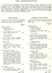
The type section is an exposure in a gravel pit 3 miles west of Mounds, SW SW SW Sec. 7, T. 16 S., R. 1 W., Pulaski County, described as the Cache Section (table 6). The Mounds Gravel is classified as a formation.
| Table 6 -- Stratigraphic Sections (partial) The following 21 stratigraphic sections describe exposures in Illinois and illustrate many of the aspects of Pleistocene stratigraphy. These sections contain the type localities for 21 rock-stratigraphic units, 4 soil-stratigraphic units, and 3 time-stratigraphic units and include paratypes for several other units. The sample numbers preceded by "P" are the numbers used in the Illinois State Geological Survey collections. Analytical data on many of these samples are on file at the Survey. The sections are arrange alphabetically by name. |
Stratigraphic relationships
In southern Illinois the Mounds Gravel has commonly been related to three terrace surfaces-- the upper, called Karbers Ridge, Ozark, Calhoun, Lancaster, or Williana, at an elevation of 580 to 620 feet; the middle, called McFarlan, Central Illinois, Bentley, or Smithland, at 450 to 500 feet; and a lower terrace, called Elizabethtown, Montgomery, or Havana, at 380 to 400 feet. In addition, gravel similar in composition occurs locally at the level of the Ohio River-- for instance, at Ft. Massac State Park at Metropolis, Massac County, at an elevation of about 300 feet. The gravel at all these levels is almost identical in character, except for local differences in coarseness. The validity of the terraces as separate erosional benches, capped by gravel generally less than 20 feet thick, is open to question. The middle and upper terraces may be part of a single alluvial fan (Potter, 1955a); in places the benches may be erosional on the gravel; and in other places the apparent relief may be the result of post-gravel warping.
Extent and thickness
Although the Mounds Gravel is nearly continuous in the area south of the Cache Valley, it is represented only by scattered pebbles north of the valley, except in the upland bordering the Mississippi Valley south of Thebes (Pryor and Ross, 1962). Similar gravel also has been observed on top of the Shawneetown Hills (Butts, 1925).
Lithology
The Mounds Gravel consists of the brown chert gravel and associated red sand that occur south of the Shawnee Hills of southern Illinois.
The gravel is composed dominantly of medium to dark brown chert pebbles, most of which are considerably rounded, and some even well rounded. Completely angular pebbles are scarce. Well rounded quartz pebbles, most of them less than half an inch in diameter, are abundant. The lithology and mineral composition of the deposits has been described in detail elsewhere (Lamar and Reynolds, 1951; Potter, 1955a).
The Mounds Gravel is derived largely from the Tennessee Valley. However, the gravel near the Mississippi Valley west of the Cache Valley and south of Thebes contains the purple quartzite, jasper, and agate that occur in the Grover Gravel and were derived from the Precambrian rocks of the Lake Superior region. The Mounds Gravel contains much higher percentages of kyanite and staurolite than the Grover Gravel, and its chert pebbles are darker brown and more polished.
Age and correlation
In the region from Mountain Glen, Union County, south to Elco, Alexander County, the dominantly light gray chert gravel with a kaolinite clay matrix that contains dark gray and black chert pebbles and abundant quartz pebbles is correlated with the Tuscaloosa Gravel of Cretaceous age, as are similar finer gravels in the same area that are made up largely of small quartz pebbles.
The Mounds Gravel truncates Paleozoic, Mesozoic, and Tertiary formations, the youngest of which in Illinois is the Eocene Wilcox Formation in the vicinity of Cairo. Farther south the gravel truncates Pliocene sediments and therefore is Pliocene or younger. The gravel at all levels is overlain by the Illinoian Loveland Silt, and it was weathered and deeply eroded before deposition of the loess. Because the gravel lacks the characteristic mineralogy of glacial outwash and was deposited before the deep channels of the Mississippi and Ohio Rivers were eroded, it generally has been assigned a Teritary age. However, the Tennessee Valley source of most of the gravel in southern Illinois can account for the lack of glacial mineralogy. Also, as previously noted, evidence in the Upper Mississippi Valley, although limited, suggests that deep valley incision followed the Nebraskan glaciation and may, in fact, have been initiated by Nebraskan glaciers' establishing the course of the Mississippi River across the Shawnee Hills. In view of these uncertainties, it is preferable to consider the Mounds Gravel as Pliocene-Pleistocene in age.
References
AMOS, D. H., 1967, Geologic map of the Smithland Quadrangle, Livingston County, Kentucky: United States Geological Survey and Kentucky Geological Survey Geologic Quadrangle Map GQ-657.
BUTTS, CHARLES, 1925, Geology and mineral resources of the Equality-Shawneetown area (parts of Gallatin and Saline Counties): Illinois State Geological Survey Bulletin 47, 76 p. (in cooperation with United States Geological Survey).
FINCH, W. I., 1966, Geologic map of the Paducah West and part of the Metropolis Quadrangles, Kentucky-Illinois: United States Geological Survey and Kentucky Geological Survey, Geologic Quadrangle Map GQ-577.
FISK, H. N., 1944, Geological investigation of the alluvial valley of the lower Mississippi River: Mississippi River Commission, War Department, Corps of Engineers, United States Army, 78 p.
FISK, H. N., and others, 1949, Geological investigation of gravel deposits in the lower Mississippi Valley and adjacent uplands: Mississippi River Commission, Corps of Engineers, United States Army Technical Memorandum 3-273.
HORBERG, C. L., 1950a, Bedrock topography of Illinois: Illinois State Geological Survey Bulletin 73, 111 p.
LAMAR, J. E., and R. R. REYNOLDS, 1951, Notes on the Illinois "Lafayette" Gravel: Illinois Academy of Science Transactions, v. 44, p. 95-108.
LEIGHTON, M. M., and H. B. WILLMAN, 1949, Late Cenozoic geology of Mississippi Valley: Itinerary 2nd Biennial State Geologists Field Conference, Illinois State Geological Survey, 86 p.
OLIVE, W. W., 1966, Geologic map of the Paducah East Quadrangle in western Kentucky: United States Geological Survey and Kentucky Geological Survey Geologic Quadrangle Map GQ-531.
POTTER, P. E., 1955a, The petrology and origin of the Lafayette Gravel. Pt. 1—Mineralogy and petrology: Journal of Geology, v. 63, no. 1, p. 1-38.
POTTER, P. E., 1955b, The petrology and origin of the Lafayette Gravel. Pt. 2—Geomorphic history: Journal of Geology, v. 63, no. 2, p. 115-132.
PRYOR, W. A., and C. A. ROSS, 1962, Geology of the Illinois parts of the Cairo, La Center, and Thebes Quadrangles: Illinois State Geological Survey Circular 332, 39 p.
ROSS, C. A., 1964, Geology of the Paducah and Smithland Quadrangles in Illinois: Illinois State Geological Survey Circular 360, 32 p.
SALISBURY, R. D., 1891a, A further note on the age of orange sands: American Journal of Science, ser. 3, v. 42, no. 249, art. 24, p. 252-253.
WELLER, J. M., 1940, Geology and oil possibilities of extreme southern Illinois—Union, Johnson, Pope, Hardin, Alexander, Pulaski, and Massac Counties: Illinois State Geological Survey Report of Investigations 71, 71 p.
WELLER, STUART, CHARLES BUTTS, L. W. CURRIER, and R. D. SALISBURY, 1920, The geology of Hardin County and the adjoining part of Pope County: Illinois State Geological Survey Bulletin 41, 402 p. (in cooperation with United States Geological Survey).
ISGS Codes
| Stratigraphic Code | Geo Unit Designation |
|---|---|

