Glasford Formation
Lithostratigraphy: Glasford Formation
Chronostratigraphy: Cenozoic Erathem >>Quaternary System >>Pleistocene Series
Primary source
Willman, H. B., and John C. Frye, 1970, Pleistocene Stratigraphy of Illinois: Illinois State Geological Survey Bulletin 94, 204 p.
Contributing author(s)
H. B. Willman and John C. Frye
Name
Original description
Glasford Formation (Willman and Frye 1970).
Derivation
The Glasford Formation is herein named for Glasford, Peoria County, Illinois.
Other names
The Glasford Formation has previously been called Illinoian till or Illinoian drift and is described in many reports, of which the following are representative of various areas (Leverett, 1899a; Leighton, 1923a, 1959; Wanless, 1929a, 1957; Lamar, 1925a, 1925b; Ball, 1952; Horberg, 1953, 1956; Leighton and Brophy, 1961; Willman, Glass, and Frye, 1963; Frye, Willman, and Glass, 1964; Johnson, 1964; Frye et al., 1969; Jacobs and Lineback, 1969).
History/background
Type section
Type location
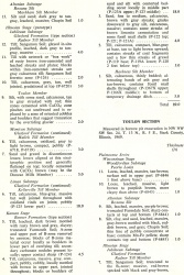
Glasford is 2 miles northeast of the type section, the Tindall School Section (table 6), SW SW NE Sec. 31, T. 7 N., R. 6 E., Peoria County.
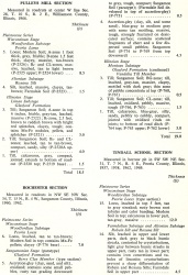
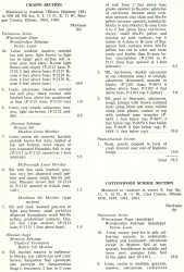
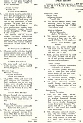
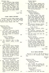
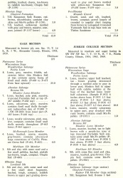
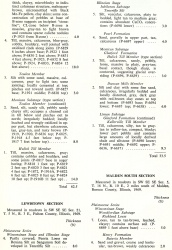
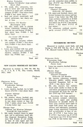
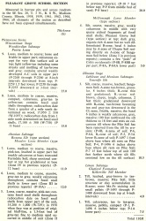
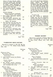
| Table 6 -- Stratigraphic Sections (partial) The following 21 stratigraphic sections describe exposures in Illinois and illustrate many of the aspects of Pleistocene stratigraphy. These sections contain the type localities for 21 rock-stratigraphic units, 4 soil-stratigraphic units, and 3 time-stratigraphic units and include paratypes for several other units. The sample numbers preceded by "P" are the numbers used in the Illinois State Geological Survey collections. Analytical data on many of these samples are on file at the Survey. The sections are arrange alphabetically by name. |
Type author(s)
Type status
Reference section
Reference location
In addition to the type section, other stratigraphic sections in table 6 that describe the Glasford Formation are Chapin, Cottonwood School, Enion, Farm Creek, Flat Rock, Jubilee College, Lewistown, New Salem Northeast, Petersburg, Pleasant Grove, Pulleys Mill, Rochester, Toulon, and Washington Grove Sections.
| Table 6 -- Stratigraphic Sections (partial) The following 21 stratigraphic sections describe exposures in Illinois and illustrate many of the aspects of Pleistocene stratigraphy. These sections contain the type localities for 21 rock-stratigraphic units, 4 soil-stratigraphic units, and 3 time-stratigraphic units and include paratypes for several other units. The sample numbers preceded by "P" are the numbers used in the Illinois State Geological Survey collections. Analytical data on many of these samples are on file at the Survey. The sections are arrange alphabetically by name. |
Reference author(s)
Reference status
Stratigraphic relationships
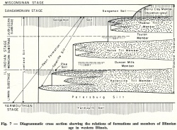
The Glasford overlies the Petersburg Silt or, in the absence of the Petersburg Silt, rests on the Yarmouth Soil; it is bounded at the top by the Sangamon Soil (fig. 7).
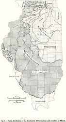
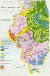
In the type section the formation is bounded at the top by the top of the Sangamon Soil developed in till, and at the base by the top of the truncated Yarmouth Soil developed in till of the Banner Formation. The Radnor Till Member, Toulon Member, Hulick Till Member, and the Kellerville Till Member make up the Glasford in the type section. The top of the Glasford Formation is defined as the top of the till and interbedded outwash or the top of the accretion-gley deposits where they overlie the till. The silt deposits overlying the Glasford in some areas, and probably equivalent in age to part of the Glasford, are classed as Teneriffe Silt, and outwash sand and gravel deposits occurring on the Glasford and extending beyond the limit of glaciation are classed as the Pearl Formation. Where the silt or the sand and gravel intertongue with the Glasford Formation, the formations are separated by vertical cutoff. These spatial relations are shown diagrammatically in figure 7, and the geographic extent of the formation is shown in figure 6. It is the formation underlying the loess in most of the area mapped as Illinoian drift on plate 2.
Subdivision of the Glasford Formation into members differs in various regions of the state. In northern Illinois the Sterling, Winslow, and Ogle Till Members are differentiated, in central and western Illinois the Berry Clay, Radnor Till, Toulon, Hulick Till, Duncan Mills, and Kellerville Till Members, and in south-central Illinois the Roby, Hagarstown, Vandalia Till, Mulberry Grove, and Smithboro Till Members. The central and western Illinois members are new, and the others, previously differentiated as informal units, are accepted here as formal members. In extreme southern and southeastern Illinois no subdivision into members has as yet been proposed, but the Berry Clay Member is present locally throughout the extent of the Glasford Formation. Within the formation, the Pike Soil and a minor unnamed soil have been recognized.
Extent and thickness
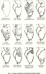
The Glasford Formation is the most widespread formation of glacial origin in Illinois, and its southernmost extent represents the southern limit of continental glaciers in the northern hemisphere (fig. 5).
Lithology
The Glasford Formation includes glacial tills, intercalated outwash deposits, and overlying accretion-gley deposits.
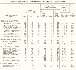
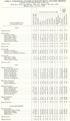
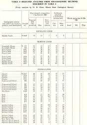
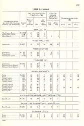
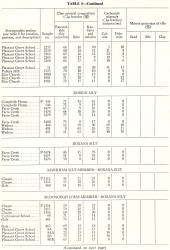
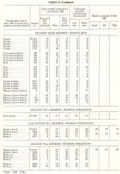
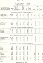
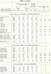
The matrix grain-size and clay mineral compositions of the tills of the formation are given in tables 2 and 5, and heavy mineral analyses are summarized in table 4. In the laboratory, the tills of the Glasford Formation can be readily distinguished from the tills of the underlying Banner Formation in western Illinois by their higher illite and dolomite content and their higher ratio of garnet to epidote among the heavy minerals; in eastern Illinois the Glasford Formation is characterized by its higher dolomite content and slightly lower ratio of garnet to epidote among the heavy minerals (table 2). The Glasford Formation tills are not so easily differentiated from the overlying tills of the Winnegbago and Wedron Formations by laboratory analysis, but the difference is generally clearly apparent on the basis of physical stratigraphy and soils.
|
Core(s)
Photograph(s)
Contacts
Well log characteristics
Fossils
Age and correlation
The Glasford Formation includes all but the earliest part of the Illinoian Stage, and all of the Sangamonian Stage. It is largely the deposit of glaciers of the Lake Michigan Lobe, but the drift in the southeastern and southern part of Illinois was deposited by the Erie Lobe.
Environments of deposition
Economic importance
Remarks
References
BALL, J. R., 1952, Geology and mineral resources of the Carlinville Quadrangle: Illinois State Geological Survey Bulletin 77, 110 p.
FRYE, J. C., H. D. GLASS, J. P. KEMPTON, and H. B. WILLMAN, 1969, Glacial Tills of Northwestern Illinois: Illinois State Geological Survey Circular 437, 47 p.
FRYE, J. C., H. B. WILLMAN, and H. D. GLASS, 1964, Cretaceous deposits and the Illinoian glacial boundary in western Illinois: Illinois State Geological Survey Circular 364, p. 28.
HORBERG, C. L., 1953, Pleistocene deposits below the Wisconsin drift in northeastern Illinois: Illinois State Geological Survey Report of Investigation 165, 61 p.
HORBERG, C. L., 1956, Pleistocene deposits along the Mississippi Valley in central western Illinois: Illinois State Geological Survey Report of Investigations 192, 39 p.
JACOBS, A. M., and J. A. LINEBACK, 1969, Glacial geology of the Vandalia, Illinois, region: Illinois State Geological Survey Circular 442, 24 p.
JOHNSON, W. H., 1964, Stratigraphy and petrography of Illinoian and Kansan drift in central Illinois: Illinois State Geological Survey Circular 378, 38 p.
LAMAR, J. E., 1925a, Geology and mineral resources of the Carbondale Quadrangle: Illinois State Geological Survey Bulletin 48, 172 p.
LAMAR, J. E., 1925b, Glacial phenomena in the vicinity of Carbondale: Illinois Academy of Science Transactions (1924), v. 17, p. 181-186.
LEIGHTON, M. M., 1923a, The differentiation of the drift sheets in northwestern Illinois: Journal of Geology, v. 31, no. 4, p. 265-281.
LEIGHTON, M. M., 1959, Stagnancy of the Illinoian glacial lobe east of the Illinois and Mississippi Rivers: Journal of Geology, v. 67, no. 3, p. 337-344.
LEIGHTON, M. M., and J. A. BROPHY, 1961, Illinoian glaciation in Illinois: Journal of Geology, v. 69, no. 1, p. 1-31.
LEVERETT, F., 1899a, The Illinois glacial lobe: United States Geological Survey Monograph 38, 817 p.
WANLESS, H. R., 1929a, Geology and mineral resources of the Alexis Quadrangle: Illinois State Geological Survey Bulletin 57, 230 p.
WANLESS, H. R., 1957, Geology and mineral resources of the Beardstown, Glasford, Havana, and Vermont Quadrangles: Illinois Geological Survey Bulletin 82, 233p.
WILLMAN, H. B., H. D. GLASS, and J. C. FRYE, 1963, Mineralogy of glacial tills and their weathering profiles in Illinois, Part 1—Glacial tills: Illinois State Geological Survey Circular 347, 55 p.
ISGS Codes
| Stratigraphic Code | Geo Unit Designation |
|---|---|
