Delafield Member
Lithostratigraphy: Carbondale Formation >>Delafield Member
Chronostratigraphy: Paleozoic Erathem >>Pennsylvanian Subsystem >>Desmoinesian Series
Allostratigraphy: Absaroka Sequence
Primary source
Nelson, W.J., P.H. Heckel and J.M. Obrad, 2022, Pennsylvanian Subsystem in Illinois: Illinois State Geological Survey, Bulletin (in press).
Contributing author(s)
W.J. Nelson
Name
Original description
The Delafield Member is described by Nelson et al. (2020) as the upward-coarsening succession of shale, siltstone, sandstone and mudstone that lies between the Hanover Limestone and the Springfield Coal in much of the Illinois Basin.
Derivation
The member is named for the now-unincorporated community of Delafield, which is close to the borehole that serves as the type section. Delafield was laid out on the St. Louis and Southeastern Railroad in 1872 and named for John Delafield (Callary 2009), who may have been an official with the railroad.
Other names
The Morgan School Shale (Ravn et al. 1984) occupies approximately the same position in Iowa and Missouri. The Morgan School ranges from less than 1 ft to about 20 ft (0.3 to 6 m) thick and consists of mudstone, shale, and siltstone, commonly containing carbonate nodules (Gentile and Thompson 2004; Pope 2012). The Morgan School differs sufficiently from the equivalent interval in Illinois that a new name for the latter appears justified.
History/background
None.
Type section
Type location
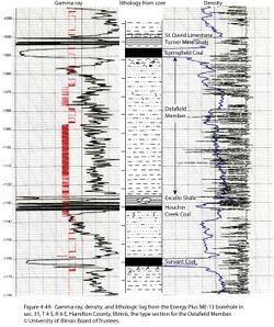
The type section is continuous core from the Energy Plus #ME-13 borehole, which was drilled about 1.6 mi (2.5 km) southeast of Delafield in sec. 31, T 4 S, R 6 E, Hamilton County (ISGS county no. 25463). The Delafield Member is 74.9 ft (22.8 m) thick and occupies the interval between the base of the Springfield Coal at 1,048.3 ft (319.5 m) to the top of the Hanover Limestone at 1,123.2 ft (342.4 m; Figure 4-49).
Type author(s)
Nelson et al. 2020.
Type status
Logs of the ME-13 boring, including a core description and a gamma ray-density log, are on file at the Geological Records Unit of the ISGS and can be downloaded from the ISGS website. Core is archived at the ISGS Geological Samples Library but presently lacks a call number.
Reference section
None is proposed here, although many cores in Illinois, Indiana, and western Kentucky encompass this unit.
Stratigraphic relationships
The Delafield Member incorporates strata between the top of the Hanover Limestone (or Excello Shale, where the Hanover is absent) and the base of (1) the Galatia Member, which fills valleys eroded into the Delafield, or (2) the Springfield Coal Member, as in the type core (Figure 4-49). The relationship to the Covel Conglomerate Bed is uncertain.
Extent and thickness
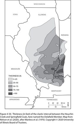
“Weiner (1961) produced a map showing the thickness of what is essentially the Delafield Member in much of the Illinois Basin. Wanless et al. (1963, figure 13) and Wanless et al. (1970, figure 4) published more legible versions of this map” (Nelson et al. 2020), which is reproduced here (Figure 4-50). “…the Delafield Member thins westward from maximum values of more than 98.4 ft (>30 m) in southwestern Indiana and southeastern Illinois. The greatest known thickness is 124.7 ft (38 m) in eastern Wayne County, Illinois.” (Nelson et al. 2020). In many places on the Western Shelf, the unit is reduced to the underclay of the Springfield Coal. In places, the Delafield cannot be identified because the Houchin Creek, Springfield, or both are missing.
Lithology
“The Delafield consistently coarsens upward. Dark gray, sideritic clay-shale that contains abundant nodules and bands of siderite is at the base. This grades upward through silty shale to siltstone and fine-grained sandstone. Shale, siltstone, and sandstone are commonly interlaminated in the upper Delafield. Structures include planar, wavy, ripple, and cross-lamination, along with slumped lamination. Definite neap–spring tidal bundles were displayed in one of the cores examined. At the top, siltstone grades upward to claystone or silty mudstone having paleosol features (Springfield underclay). The upward-coarsening profile is evident on electric and other geophysical logs” (Nelson et al. 2020). Calcareous sandstone and nodular limestone that contain marine fossils have been observed near the top of the Delafield in western Kentucky (David A. Williams, Kentucky Geological Survey, written communication, 2017).
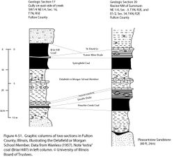
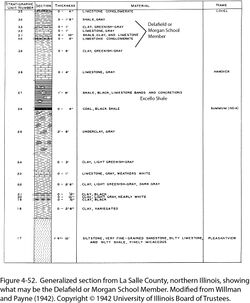
In northern and western Illinois, the Delafield is greatly thinned and consists of claystone, shale, and limestone. Sections from Fulton County in western Illinois (Figure 4-51) and LaSalle County in northern Illinois (Figure 4-52) illustrate the succession. Shale and claystone are gray to greenish gray, nonfissile to moderately fissile, silt free to silty, and calcareous. Limestone is gray, mostly micritic, and nodular to concretionary. A few marine fossils, including the brachiopod Marginifera, are present. These lithologies are similar to the Morgan School Shale in Iowa and Missouri, and perhaps that name should be used here in preference to Delafield.
Core(s)
Photograph(s)
Contacts
“The base of the Delafield Member is the top of the Hanover Limestone or, where the Hanover is absent, the top of the Excello Shale. This contact is sharp or gradational within an interval a few centimeters thick. The top of the Delafield is the base of the Springfield Coal or the base of the new Galatia Member. The contact to the coal is generally conformable but sharp, whereas the contact to the Galatia Member is erosive. Where the Galatia Member is absent, the underclay of the Springfield Coal is part of the Delafield Member.” (Nelson et al. 2020).
Well log characteristics
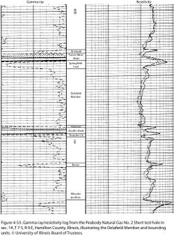
Resistivity logs reflect upward coarsening (Figure 4-53).
Fossils
“Fossils are scarce in the Delafield Member, but they record a transition from near-normal marine conditions at the outset of deposition to increasingly brackish water through time. Articulate brachiopods, crinoid fragments, and other marine forms occur at the base. Above this are found rare pectenoid pelecypods, linguloid brachiopods, a single nautiloid cephalopod, and plant fragments. Burrows are present but not common. The type core contains the trace fossils Teichichnus and Conostichus, which have marine affinities.” (Nelson et al. 2020).
Age and correlation
The Morgan School Shale in Iowa and Missouri is directly correlative (Ravn et al. 1984; Gentile and Thompson 2004). The name Morgan School might be appropriate for the thin, calcareous facies of this interval in western Illinois.
Environments of deposition
The Delafield Member consists of terrigenous clastics that prograded into the Illinois Basin from the east during late highstand and regressive phases of a eustatic cycle. Deposition apparently took place in a complex of deltas and shoaling bays. Normal marine salinity rapidly gave way to brackish water. Terrestrial clastics essentially filled the Illinois Basin as marginal marine sedimentation gave way to emergence and soil formation.
Economic importance
None.
Remarks
References
- Callary, E., 2009, Place names of Illinois: Urbana, University of Illinois Press, 425 p.
- Gentile, R.J., and T.L. Thompson, 2004, Paleozoic succession in Missouri, Part 5, Pennsylvanian Subsystem, Volume A, Morrowan strata through Cherokee Group: Missouri Geological Survey, Report of Investigations 70, 241 p. and correlation chart.
- Nelson, W.J., S.D. Elrick, W.A. DiMichele, and P.R. Ames, 2020, Evolution of a peat-contemporaneous channel: The Galatia channel, Middle Pennsylvanian, of the Illinois Basin: Illinois State Geological Survey, Circular 605, 85 p., 6 pls.
- Pope, J.P., 2012, Description of Pennsylvanian units, revision of stratigraphic nomenclature, and reclassification of the Morrowan, Atokan, Desmoinesian, Missourian, and Virgilian stages in Iowa: Iowa Geological and Water Survey, Special Report Series No. 5, 140 p.
- Ravn, R.L., J.W. Swade, M.R. Howes, J.L. Gregory, R.R. Anderson, and P.E. Van Dorpe, 1984, Stratigraphy of the Cherokee Group and revision of Pennsylvanian stratigraphic nomenclature in Iowa: Iowa Geological Survey, Technical Information Series No. 12, 76 p.
- Wanless, H.R., 1957, Geology and mineral resources of the Beardstown, Glasford, Havana, and Vermont Quadrangles: Illinois State Geological Survey, Bulletin 82, 233 p.
- Wanless, H.R., J.B. Tubb Jr., D.E. Gednetz, and J.L. Weiner, 1963, Mapping sedimentary environments of Pennsylvanian cycles: Geological Society of America Bulletin, v. 74, no. 4, p. 437–486.
- Wanless, H.R., J.R. Baroffio, J.C. Gamble, J.C. Horne, D.R. Orlopp, A. Rocha-Campos, J.E. Souter, P.C. Trescott, R.S. Vail, and C.R. Wright, 1970, Late Paleozoic deltas in the central and eastern United States, in J.P. Morgan and R.H. Shaver, eds., Deltaic sedimentation, modern and ancient: Society of Economic Paleontologists and Mineralogists, Special Publication 15, p. 215–245, https://doi.org/10.2110/pec.70.11.
- Weiner, J.L., 1961, Environmental study of stages within the Summum cyclothem of Illinois: Urbana, University of Illinois, M.S. thesis, 31 p.
- Willman, H.B., and J.N. Payne, 1942, Geology and mineral resources of the Marseilles, Ottawa, and Streator Quadrangles: Illinois State Geological Survey, Bulletin 66, 388 p., 29 pls.
ISGS Codes
| Stratigraphic Code | Geo Unit Designation |
|---|---|
