Pike Soil
Lithostratigraphy: Pike Soil
Chronostratigraphy: Cenozoic Erathem >>Quaternary System >>Pleistocene Series
Primary source
Willman, H. B., and John C. Frye, 1970, Pleistocene Stratigraphy of Illinois: Illinois State Geological Survey Bulletin 94, 204 p.
Contributing author(s)
H. B. Willman and John C. Frye
Name
Original description
Pike Soil (Willman and Frye 1970).
Derivation
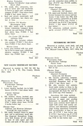
The Pike Soil is named here for Pike County from its occurrence in the New Salem Northeast Section (table 6), NW NE SW Sec. 11, T. 4 S., R. 4 W.
Other names
History/background
Type section
Type location
Type author(s)
Type status
Reference section
Reference location
Reference author(s)
Reference status
Stratigraphic relationships
At its type locality the Pike Soil is developed in the Kellerville Till Member of the Glasford Formation (Liman Substage, Illinoian Stage). It is overlain by the Teneriffe Silt (Monican and Jubileean Substages, Illinoian Stage), which contains the Sangamon Soil in its top and is overlain by Roxana Silt and Peoria Loess (fig. 7). At the relatively few localities where this soil has been studied in western Illinois, it is commonly truncated and is overlain by the Duncan Mills Member or Hulick Till Member of the Glasford Formation or by the Teneriffe Silt.
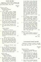
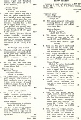
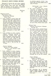
In the stratigraphic sections included in this report (table 6), the Pike Soil has been described in the Cottonwood School, Enion, New Salem Northeast, and Pleasant Grove School Sections. Mineralogical studies have been made at each of these sections. Although this soil has been observed at several other localities it seems clear that it does not occur widely— or if it does, it has been miscorrelated. The scarcity of exposures seems to be accounted for by widespread erosion before the deposition of the Hulick Till Member of the Glasford Formation. It nevertheless has considerable stratigraphic significance because it establishes the existence of a sizable unconformity after the deposition of the Kellerville Till and prior to the deposition of the Hulick Till. The significance of this hiatus is also shown by the contrast in topography between the areas where the Kellerville and Hulick are surface tills and by the greater depth of leaching of the Kellerville Till.
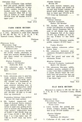
| Table 6 -- Stratigraphic Sections (partial) The following 21 stratigraphic sections describe exposures in Illinois and illustrate many of the aspects of Pleistocene stratigraphy. These sections contain the type localities for 21 rock-stratigraphic units, 4 soil-stratigraphic units, and 3 time-stratigraphic units and include paratypes for several other units. The sample numbers preceded by "P" are the numbers used in the Illinois State Geological Survey collections. Analytical data on many of these samples are on file at the Survey. The sections are arrange alphabetically by name. |
A very weakly developed soil, as yet unnamed, has been observed in the Jubilee College Section (table 6), and in a few other places below the Radnor Till Member of the Glasford Formation (fig. 7). At those places where the Duncan Mills, Hulick, and Toulon Members of the Glasford Formation were not deposited, the soil-forming interval of the Pike Soil continued until it was terminated by the advancing Radnor glacier or by deposition of the contemporaneous part of the Teneriffe Silt. Furthermore, at some places it is probable that after the deposition of the Kellerville Till the soil-forming interval continued uninterrupted until terminated by deposition of Roxana Silt. Such a soil is the Sangamon and not the Pike Soil.
Extent and thickness
Lithology
The Pike Soil presents a strongly developed, clayey, red-brown profile, lacking strongly developed peds, or structure, and Mn-Fe pellets.
Core(s)
Photograph(s)
Contacts
Well log characteristics
Fossils
Age and correlation
Environments of deposition
Economic importance
Remarks
References
ISGS Codes
| Stratigraphic Code | Geo Unit Designation |
|---|---|
