Peoria Silt
Lithostratigraphy: Mason Group >>Peoria Silt
Chronostratigraphy: Cenozoic Erathem >>Quaternary System >>Pleistocene Series
Primary source
Hansel, Ardith K., and W. Hilton Johnson, 1996, Wedron and Mason Groups: Lithostratigraphic Reclassification of Deposits of the Wisconsin Episode, Lake Michigan Lobe Area: Illinois State Geological Survey Bulletin 104, 116 p.
Contributing author(s)
Ardith K. Hansel and W. Hilton Johnson
Name
Original description
Peorian soil and weathering interval (Leverett 1899).
Derivation
Peoria, a city along the Illinois Valley in Peoria County.
Other names
History/background
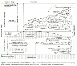
The term Peorian was introduced by Leverett (1899) for a soil that he inferred to have formed during an interglacial interval. Later, Alden and Leighton (1917) applied the term to loess deposits previously called Iowan. Kay and Leighton (1933) restricted usage of the term Peorian to loess beyond the limit of the Shelbyville till (the Wedron Group of this report). The name was modified to Peoria loess by Frye and Leonard (1951) for use as a lithostratigraphic unit in Kansas, and that usage was introduced in Illinois by Frye and Willman in 1960. In 1970, Willman and Frye designated separate formations for the unit below, beyond, and above the diamicton deposits of the last glacial episode. They are the Morton, Peoria, and Richland Loesses, respectively. At the glacial limit, the Morton and Richland Loesses were separated from laterally equivalent silt of the Peoria Loess by arbitrary vertical boundaries (fig. 3).
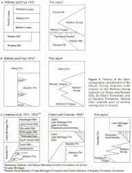
We have retained the Peoria Silt as a lithostratigraphic unit at formation rank. The former Morton and Richland Loesses are not retained at formation rank; instead, they are treated as tongues of the Peoria Silt that underlie and overlie the Wedron Group, respectively (fig. 9a). The Morton Tongue is a thin (generally less than 2 m [6.6 ft] thick) subsurface unit that is present only within a zone about 50 kilometers (31 mi) wide in the up-ice direction from the western and southern margins of the Wedron Group (Kempton and Gross 1971). It is recognized in this report as a formal tongue of the Peoria Silt. By contrast, the Richland tongue is not recognized as a formal tongue of the Peoria Silt; instead, the name Peoria Silt is applied to the unit both beyond and above the Wedron Group. This practice is consistent with how the uppermost tongues of the Equality and Henry Formations are treated, and it has been the practice of some other scientists in Illinois (e. g., Fehrenbacher et al. 1986).
Locally, the Peoria Silt is interfingered with well-sorted (eolian) sand. Where at the surface, this sand was formerly classified as the Parkland Sand. In this report, the Parkland Sand is not retained as a formal unit, but sand intertonguing with silt of the Peoria Silt could be recognized as the Parkland facies of the Peoria Silt.
Type section
Type location
Tindall School Section in the west bluff of the Illinois Valley south of Peoria; good for lithology and lower boundary.
Type author(s)
Type status
Reference section
Reference location
Athens North Quarry, Bellefontaine Quarry, and Cottonwood School Sections; all good for lithology and lower boundary. Danvers, Gardena, and Farm Creek Sections; all good for lithology, lower boundary, and intertonguing relationship with the Tiskilwa Formation of the Wedron Group.
Reference author(s)
Reference status
Stratigraphic relationships
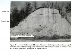
The Peoria Silt consists of a silt unit that overlies the Roxana Silt (fig. 29) or other units and interfingers with diamicton units of the Wedron Group and sorted sediment units of the Henry and Equality Formations of the Mason Group, of which it is a part. Where it is at the surface, the modern soil has developed in its upper part (fig. 29). The lower tongue of the Peoria Silt that extends below the Delavan Member or undivided Tiskilwa Formation of the Wedron Group is recognized herein as the Morton Tongue of the Peoria Silt.
The Peoria Silt is differentiated from the red brown Roxana Silt or older silt units by its yellow brown to gray color, lack of significant weathering and soil characteristics below the modern soil, presence of carbonates (predominantly dolomite), and stratigraphic position.
Extent and thickness
The Peoria Silt is an extensive unit that occurs throughout the midcontinent region. It extends north to Minnesota and Wisconsin, east to Ohio, south to Mississippi and Louisiana, and west to Kansas and Nebraska (Ruhe 1983). It is clearly valley related and thickest along the Illinois, Mississippi, Missouri, Wabash, and Ohio River valleys, where it ranges from 10 to 25 meters (33-82 ft) thick in the bluff area along the widest portions of these valleys. It thins away from the valleys, but is present in most upland areas beyond the boundary of Michigan Subepisode glaciation (Smith 1942, Leighton and Willman 1950, McKay 1979b, Fehrenbacher et al. 1986).
Lithology
The Peoria Silt generally is light yellow tan to gray silt that grades from sandy silt in the bluffs of major source valleys to clayey silt away from the bluffs, where it typically is thinner and weathered. It is dolomitic below the weathered zone and generally lacks bedding structures, although faint bedding is sometimes observable in thick bluff sections near major river valleys. Locally, it may contain beds of well-sorted sand, fossil snail shells, organic debris, wood, and rarely clay layers. At the Gardena and Danvers Sections in Tazewell and McLean Counties, respectively, the Morton Tongue of the Peoria Silt contains a thin organic layer, including an in situ moss bed in the upper few centimeters.
Core(s)
Photograph(s)
Contacts
Lower boundary: the generally gradational contact with the Roxana Silt or older units. Upper boundary: the contact with upper tongues of the Henry and Equality Formations, postglacial units, or the land surface; the modern soil has developed in the upper part of the unit.
Well log characteristics
Fossils
Age and correlation
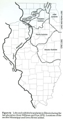
The Peoria Silt was deposited adjacent to major meltwater channels during the Michigan Subepisode. Deposition began at different times in different valleys, depending on the time meltwater was released from the glacier to ancient drainageways (appendix B2). For example, adjacent to the lower Illinois (ancient Mississippi) Valley in central and western Illinois, deposition of the Peoria Silt began about 25,000 radiocarbon years ago or slightly earlier (McKay 1979b). Near the Mississippi (ancient Iowa) Valley in western Illinois, however, loess deposition did not begin until about 20,000 radiocarbon years ago, after the advancing Lake Michigan Lobe had diverted the ancient Mississippi River to its present course along the western boundary of Illinois (fig. 4a). Most of the Peoria Silt was deposited by about 12,500 radiocarbon years ago. The Peoria Silt correlates with the Vicksburg Loess in Mississippi (Krinitzsky and Turnbull 1967) and part of the Atherton Formation (Wayne 1963) in Indiana.
Environments of deposition
The Peoria Silt is interpreted to be predominantly proglacial loess derived from glacial meltwater channels. The Morton Tongue, which was derived primarily from the Illinois (ancient Mississippi) River valley, was later overridden by the advancing glacier during the Michigan Subepisode. In some areas the Peoria Silt contains small amounts of eolian sand, and locally it contains colluviated and sheetwash silt.
Economic importance
Remarks
Revised unit. Formation extended to include the former Morton and Richland Loesses; silt used in name to replace lithogenetic term loess.
References
ALDEN, W. C., and M. M. LEIGHTON, 1917, The Iowan drift, a review of the evidences of the Iowan Stage of glaciation: Iowa Geological Survey Annual Report, 1915, v. 26, p. 49-212.
FEHRENBACHER, J. B., I. J. JANSEN, and K. R. OLSON, 1986, Loess Thickness and Its Effect on Soils in Illinois: University of Illinois Agricultural Experimental Station (in cooperation with Soil Conservation Service, USDA), Bulletin 782, 14 p.
FRYE, J. C., and A. B. LEONARD, 1951, Stratigraphy of the late Pleistocene loesses of Kansas: Journal of Geology, v. 59, no. 4, p. 287-305.
FRYE, J. C., and H. B. WILLMAN, 1960, Classification of the Wisconsinan Stage in the Lake Michigan Glacial Lobe: Illinois State Geological Survey Circular 285, 16 p.
KAY, G. F, and M. M. LEIGHTON, 1933, Eldoran epoch of the Pleistocene period: Geological Society of America Bulletin, v. 44, no. 4, p. 669-674.
KEMPTON, J. P., and D. L. GROSS, 1971, Rate of advance of the Woodfordian (Late Wisconsinan) glacial margin in Illinois— Stratigraphic and radiocarbon evidence: Geological Society of America Bulletin, v. 82, no. 11, p. 3245-3250.
KRINITZSKY, E. L., and W. J. TURNBULL, 1967, Loess Deposits of Mississippi: Geological Society of America Special Papers, no. 94, 64 p.
LEIGHTON, M. M., and H. B. WILLMAN, 1950, Loess formations of the Mississippi Valley: Journal of Geology, v. 58, no. 6, p. 599-623. (Reprinted as Illinois State Geological Survey Report of Investigations 149)
LEVERETT, F., 1899, The Illinois Glacial Lobe: United States Geological Survey Monograph 38, 817 p.
McKAY, E. D., 1979b, Wisconsinan loess stratigraphy of Illinois, in L. R. Follmer, E. D. McKay, J. A. Lineback, and D. L. Gross, Wisconsinan, Sangamonian, and Illinoian Stratigraphy in Central Illinois: Illinois State Geological Survey Guidebook 13, p. 95-108.
RUHE, R. V., 1983, Depositional environments of Late Wisconsin loess in the midcontinental United States, in H. E. Wright, Jr., and S. C. Porter, editors, Late Quaternary Environments of the United States, Volume 1, The Late Pleistocene: University of Minnesota Press, Minneapolis, p. 130-137.
SMITH, G. D., 1942, Illinois loess, variations in its properties and distributions— A pedologic interpretation: University of Illinois Agricultural Experiment Station, Bulletin 490, p. 138-184.
WAYNE, W. J., 1963, Pleistocene Formations of Indiana: Indiana Geological Survey Bulletin 25, 85 p.
WILLMAN, H. B., and J. C. FRYE, 1970, Pleistocene Stratigraphy of Illinois: Illinois State Geological Survey Bulletin 94, 204 p.
ISGS Codes
| Stratigraphic Code | Geo Unit Designation |
|---|---|


