Historical:Enion Formation
Lithostratigraphy: Enion Formation
Chronostratigraphy: Cenozoic Erathem >>Quaternary System >>Pleistocene Series
Authors
H. B. Willman and John C. Frye
Name origin
The Enion Formation is named for Enion, Fulton County.
Type section
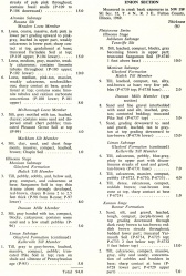
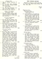
The type section is the Enion Section (table 6), an exposure in a ravine half a mile west of Enion, NW SW SE Sec. 32, T. 4 N., R. 3 E., Fulton County, originally described by Wanless (1929b; 1957, fig. 51, geol. sec. 62). The Enion Formation is also described in the Zion Church Section in Adams County (table 6).
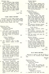
| Table 6 -- Stratigraphic Sections (partial) The following 21 stratigraphic sections describe exposures in Illinois and illustrate many of the aspects of Pleistocene stratigraphy. These sections contain the type localities for 21 rock-stratigraphic units, 4 soil-stratigraphic units, and 3 time-stratigraphic units and include paratypes for several other units. The sample numbers preceded by "P" are the numbers used in the Illinois State Geological Survey collections. Analytical data on many of these samples are on file at the Survey. The sections are arrange alphabetically by name. |
Stratigraphic relationships
The Enion Formation includes the glacial tills, outwash, and intercalated silts occurring below the base of the Banner Formation or the top of the Afton Soil; it overlies bedrock formations or the Grover Gravel.
Extent and thickness
Exposures of the Enion Formation are known in a relatively small number of localities in central western Illinois. In most of these the till is distorted, and the quantity so small that there is no assurance that the till has not been transported. The high-level outwash gravels of Jo Daviess County (Willman and Frye, 1969) are also included within the formation.
Age and correlation
The Enion Formation is Nebraskan in age. Deposits that might possibly be assigned to the Enion Formation have been described in other areas in Illinois, but the correlations at present are considered questionable and most of the deposits are included in the Banner Formation. These include the drift called Nebraskan (?) in De Witt, McLean, and Livingston Counties (Horberg, 1953) and in Vermilion County (Eveland, 1952). Later examination of an exposure thought to include till of Nebraskan age near Winchester, Scott County (Bell and Leighton, 1929), indicated that the lower till was Kansan rather than Nebraskan (G. E. Ekblaw, personal communication). Gravel resting on bedrock and overlain by the Banner Formation in Fulton and adjacent counties (Wanless, 1957) contains a few igneous pebbles and may be of the same age as the Enion, but it is dominantly chert gravel and is included in the Grover Gravel.
Environments of deposition
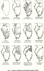
It was deposited by glaciers that advanced from the Keewatin center across Minnesota and Iowa and invaded western and northwestern Illinois (fig. 5).
References
BELL, A. H., and M. M. LEIGHTON, 1929, Nebraskan, Kansan, and Illinoian tills near Winchester, Illinois: Geological Society of America Bulletin, v. 40, no. 2, p. 481-489.
EVELAND, H. E., 1952, Pleistocene geology of the Danville region: Illinois State Geological Survey Report of Investigations 159, 32 p.
HORBERG, C. L., 1953, Pleistocene deposits below the Wisconsin drift in northeastern Illinois: Illinois State Geological Survey Report of Investigation 165, 61 p.
WANLESS, H. R., 1929b, Nebraskan till in Fulton County, Illinois: Illinois Academy of Science Transactions (1928), v. 21, p. 273-282.
WANLESS, H. R., 1957, Geology and mineral resources of the Beardstown, Glasford, Havana, and Vermont Quadrangles: Illinois State Geological Survey Bulletin 82, 233 p.
WILLMAN, H. B., and J. C. FRYE, 1969, Highlevel glacial outwash in the Driftless Area of northwestern Illinois: Illinois State Geological Survey Circular 440, 23 p.
ISGS Codes
| Stratigraphic Code | Geo Unit Designation |
|---|---|
