Pleistocene Series
Chronostratigraphy: Cenozoic Erathem >>Quaternary System >>Pleistocene Series
Primary source
Willman, H. B., Elwood Atherton, T. C. Buschbach, Charles Collinson, John C. Frye, M. E. Hopkins, Jerry A. Lineback, and Jack A. Simon, 1975, Handbook of Illinois Stratigraphy: Illinois State Geological Survey Bulletin 95, 261 p.
Contributing author(s)
John C. Frye and H. B. Willman
Name
Original description
Derivation
Other names
History/background
The term "Pleistocene" was introduced by Lyell in 1839 (p. 616-621) as a replacement for "Newer Pliocene" (Lyell, 1833, p. 52-53) to apply to the marine strata of the Mediterranean region, in which more than 70 percent of the fossils represent living species. In 1846 Forbes applied "Pleistocene" to the "glacial epoch" in the British Isles, and in 1925 Wilmarth defined the Pleistocene in North America as including glacial and contemporaneous deposits of the "Great Ice Age." A report to the International Geological Congress in 1952 suggested worldwide adoption of a definition of the base of the Pleistocene as the base of the Villafranchian or of the equivalent marine Calabrian as exposed in Italy. However, as correlations of this proposed type area with marine strata in North America are not firmly established, the Pleistocene Series in Illinois and the rest of the continental interior continues to be defined as the glacial sequence plus the contemporaneous deposits laid down beyond the limit of continental glaciation. The Pleistocene Series includes the Holocene (Recent), which is classified as a stage rather than as a separate series, the usage accepted by many others.
Type section
Type location
Type author(s)
Type status
Reference section
Reference location
Reference author(s)
Reference status
Stratigraphic relationships
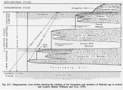
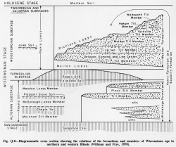
The stratigraphic relations of Pleistocene deposits in Illinois are complex and contrast sharply with the more regular and uniform succession of predominantly marine Paleozoic rocks that they overlie. The complexity is caused by the different modes of deposition, the multiple sources of sediment, and the lack of regional continuity of many of the stratigraphic units. The loesses and the soil-stratigraphic units have the greatest regional continuity, although some of the glacial till units are traceable for more than 100 miles. Outwash and alluvial deposits, in general, occur along present and buried valleys, lacustrine deposits are found along segments of ponded valleys and on low areas of the till plain surfaces, and colluvium and gravity deposits are restricted to localized areas along valley margins. An idealized representation of stratigraphic relations of deposits of the Illinoian Stage in west-central and western Illinois is shown by figure Q-7, and another of Wisconsinan deposits from northeastern to west-central Illinois by figure Q-8.
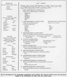
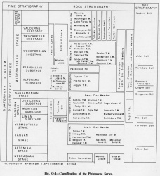
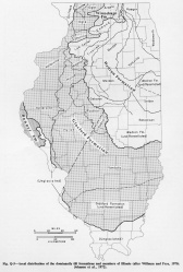
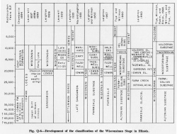
Pleistocene deposits in Illinois are classified in four basic hierarchies-- time-stratigraphic, rock-stratigraphic, soil-stratigraphic, and morphostratigraphic. Time-stratigraphic and rock-stratigraphic classifications are used for Pleistocene deposits in the same manner they are used in the rest of the stratigraphic sequence (fig. 16) and will not be redescribed here. The chart in figure Q-4 shows all time-stratigraphic, rock-stratigraphic, and soil-stratigraphic terms currently in use in Illinois and this report. The surface distribution of the dominantly till formations and members is shown in figure Q-5. Figure Q-6 shows graphically the historical development of the time-stratigraphic classification of the Wisconsinan Stage in Illinois.
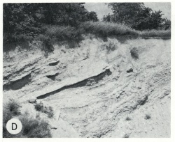
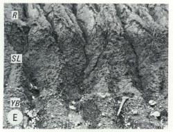
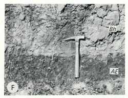
Soil-stratigraphic and morphostratigraphic units are virtually unique to the Pleistocene. Soils form at the land surface as a result of the effects of weathering and of plants and animals on the sediments that underlie the surface. In most places soil forms in situ, that is, by the progressive downward alteration of sediments below a relatively stable surface. In some places, however, soils have formed by slow accumulation of fine sediment on the surface, with or without organic material. Soils buried by younger sediments are part of the stratigraphic sequence. Soil-stratigraphic classification, consisting of only one rank (soil), is a means of naming, describing, and correlating the soils in the sediment sequence. Soils do not replace the rock-stratigraphic units they are developed on; commonly, each soil is developed on several units. Only the upper surface of a soil presents a definable stratigraphic plane, because the lower part of a soil is gradational. The physical and mineral characteristics of a soil profile are generally useful in its recognition and correlation.
Morphostratigraphic units, as the name implies, are bodies of rock that are recognized and named on the basis of their surface form. Glacially produced morainic ridges, the materials in which are called drifts, and dissected alluviated surfaces, called alluvial terraces, are the two types of morphostratigraphic units recognized in Illinois. Only the drifts are formally named. Drifts are recognized not only in the surface areas but also wherever they can be identified in buried sequences. Such units are particularly useful in classification and mapping of glacial deposits in areas where a single rock-stratigraphic unit, such as glacial till, includes several morainic ridges.
Extent and thickness
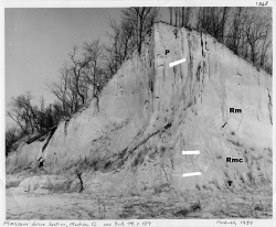
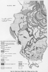
Deposits of Pleistocene age are the surficial materials in virtually all of Illinois (fig. Q-1). Nearly 80 percent of the state was covered at least once by continental glaciers that left characteristic deposits (drift). Both glaciated and unglaciated areas were largely covered by wind-deposited silt (loess), by lacustrine deposits, or by deposits from streams. The only areas that were not covered by glaciers are the extreme northwestern corner, the southernmost part, and relatively small areas along the western border (fig. Q-2).
|
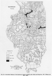
The thickness of the Pleistocene deposits in Illinois ranges from zero to approximately 600 feet (fig. Q-3), and variations in thickness occur sharply in relatively small areas. The drift is thick where major valleys in the older rocks have been filled by Pleistocene deposits and where stillstands of a glacier front have built thick ridges (moraines) of glacial debris. Drift thicknesses are greatest where glacial moraines cross the filled valleys. The loess deposits, which were derived largely from glacial outwash in the major valleys by the action of winds, are thickest along the margins of those valleys and thin rapidly away from them, in some places thinning from as much as 100 feet to less than 20 feet thick in a distance of 10 miles. Loess disappears entirely on the surfaces of alluvial valleys and some of the lake plains. Dune sands vary abruptly in thickness and do not display the regular, linear pattern of the loess deposits.
Lithology
The mineral composition of Pleistocene deposits strongly reflects the source areas of the sediments. Source areas of colluvial and gravity deposits are close at hand, but glacial deposits reflect sources hundreds of miles away. Glacial till contains rocks and minerals picked up by the ice as the glaciers advanced; the heavy minerals of the sands were commonly derived from the crystalline rocks of southern Canada and the clay minerals and carbonates from the Paleozoic rocks farther south. The mineral compositions of the older rocks vary widely from east to west, and, consequently, the direction of ice flow and the correlation of many units can be determined by mineral analysis of the tills. As the sediments of the outwash were derived largely from the glacially transported material, their mineral composition and that of the eolian deposits derived from them also reflect the sources of the glacial deposits.
The tills from a northwestern source (Keewatin Lobe) are characterized by high montmorillonite content, more calcite than dolomite, and more epidote than garnet. Tills from the north and northeast (Lake Michigan Lobe) have a high illite content, much more dolomite than calcite, and nearly equal amounts of garnet and epidote. Tills from farther east (Saginaw, Huron, Erie Lobes) have a high illite content, generally more calcite than dolomite, and much more garnet than epidote.
Core(s)
Photograph(s)
Contacts
Well log characteristics
Fossils
Fossils are not abundant in most of the Pleistocene deposits of Illinois. None have thus far been found in the Nebraskan Stage, and assemblages of fossil mollusks have been collected and described from less than a dozen localities of the Kansan Stage. Several silt units of the Illinoian Stage contain relatively abundant assemblages of fossil mollusks at localities in the central and western parts of the state. The Wisconsinan and Holocene Stages contain abundant assemblages of both aquatic and terrestrial mollusks. Fossil vertebrates have also been collected from Pleistocene deposits at many localities. Although the remains of large proboscidians, such as mammoths and mastodons, have attracted the most attention, remains of smaller mammals, particularly rodents, have been recovered from several localities.
Age and correlation
Environments of deposition
The Pleistocene deposits in Illinois also have a wide range in lithology-- bouldery glacial tills, well sorted silts, accretion-gley, and fine-grained lacustrine clays. Glacial tills strongly reflect their mode of origin and their source areas. Glacial regimen changes with the temperature and thickness of the ice, the rate of ice flow, and the manner in which the ice disappeared. In some areas excess of marginal melting over forward motion caused retreat of the ice front. In other areas the ice lost forward motion, stagnated, and melted down from the top. All of these factors influence the resulting deposit. Glacial tills range from dominantly sand and gravel with only a
small fraction of clay and silt and a few small boulders to mixtures dominantly clay or silt, with some sand, pebbles, and dispersed boulders.
Alluvial deposits are the product of normal stream action, of meltwaters in, on, or below glacial ice, or of meltwaters flowing from glaciers to a considerable distance (outwash). These deposits range from coarse, bouldery gravel to sand and silt.
Eolian deposits of loess and dune sand result from the action of winds on exposed surfaces of nonindurated materials, mostly glacial outwash. Eolian sediments are well sorted, consisting largely of medium-grained sand in the dunes and coarse to fine silt in the loess deposits. Loess deposits progressively thin and become finer grained away from their source areas in the major valleys. They range from coarse silt containing fine sand immediately adjacent to their source to fine silt containing significant amounts of clay in remote areas.
During Pleistocene time lakes formed along glacial fronts, between morainic ridges, in valleys dammed by glaciers, and in tributary valleys blocked by rapidly alluviating master streams that were receiving large quantities of outwash. The lacustrine deposits are predominantly well bedded silt, clay, and fine to medium sand. Although most lacustrine sediments are largely silt, some are predominantly sand, and others are interbedded silt, sand, and clay.
Colluvium and gravity deposits are produced by the influence of gravity on slopes. The materials in such deposits strongly reflect the local source from which they were derived, which is always up-slope from the deposit. The two categories are differentiated largely by rate of transport and particle size. Colluvial deposits move slowly down-slope, commonly contain a significant percentage of silt, clay, and some coarser fragments, and may or may not have a well defined slip plane separating them from the older rocks below. Gravity deposits are generally composed of angular fragments, are more poorly sorted, are coarser, and are associated with steeper slopes than colluvium. They include talus deposits. Both colluvium and gravity deposits are poorly sorted unless the source material is a uniform and well sorted sediment, such as loess.
Man-made deposits are extensively exposed at the surface in strip-mined areas, filled areas, and artificially created islands. Sanitary landfills also are man-made surficial deposits. Such deposits have no predictable lithology and range from refuse and stripped overburden of mines to relatively uniform sand or silt.
Economic importance
Remarks
The Nebraskan and Kansan Stages are now considered to be obsolete.
References
FORBES, EDWARD, 1846, On the connection between the distribution of the existing fauna and flora of the British Isles, and the geological changes which have affected their area, especially during the epoch of the northern drift: Great Britain Geological Survey Memoir, v. 1, p. 336-432.
LYELL, CHARLES, 1833, Principles of geology: v. 3, London, p. 52-55, 57-58.
LYELL, CHARLES, 1839, Elements of geology: Pitois-Lerault and Co., Paris, 648 p. [French translation].
WILMARTH, M. G., 1925, Geologic time classification of the United States Geological Survey compared with other classifications: United States Geological Survey Bulletin 769, 138 p.
ISGS Codes
| Stratigraphic Code | Geo Unit Designation |
|---|---|
