Sangamon Soil
Lithostratigraphy: Sangamon Soil
Chronostratigraphy: Cenozoic Erathem >>Quaternary System >>Pleistocene Series
Primary source
Willman, H. B., and John C. Frye, 1970, Pleistocene Stratigraphy of Illinois: Illinois State Geological Survey Bulletin 94, 204 p.
Contributing author(s)
H. B. Willman and John C. Frye
Name
Original description
Sangamon Soil (Leverett 1898b).
Derivation
The Sangamon Soil was named by Leverett (1898b) on the basis of a description of a soil in a well in Sangamon County given by Worthen (1873b).
Other names
History/background
Leverett described the soil as occurring below deposits of Wisconsinan age and typically developed in the northwestern part of Sangamon County and the neighboring parts of Menard County. The original section described by Worthen was not examined by Leverett or by subsequent workers, and it seems appropriate, therefore, to designate several reference sections that are available for examination in the region surrounding the type locality. Two described stratigraphic sections included with this report may be regarded as paratypes.
Type section
Type location
Type author(s)
Type status
Reference section
Reference location
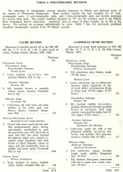
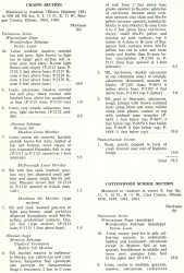
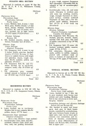
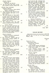
The Chapin Section (table 6), NW SE NE Sec. 8, T. 15 N., R. 11 W., Morgan County (adjacent to Sangamon County on the west), serves as a representative and easily accessible reference section. The Sangamon Soil here is an in-situ profile developed in till of the Hulick Till Member of the Glasford Formation. It is overlain by the Markham Silt Member of the Roxana Silt, and thus the top of the profile is at the defined position for the Sangamon Soil. However, as the profile is developed in the Hulick Member, with
the Radnor Till Member and Toulon Member of the Glasford Formation missing, the interval of soil formation was longer than the Sangamonian Stage, and the profile is somewhat more strongly developed than it is where the soil is developed in the Radnor Till Member. Carbonate minerals are leached to a depth of 6.5 feet, and the B2-zone is 2 feet thick, red-brown, and clayey, with Mn-Fe pellets and staining.
The Rochester Section (table 6), NW SE NW Sec. 34, T. 15 N., R. 4 W., eastern Sangamon County (Frye, Willman, and Glass, 1960), serves as a representative section of the Sangamon Soil accretion-gley profile. Here, the accretion-gley deposit, classed as the Berry Clay Member of the Glasford Formation, is typical of the intrazonal soil profile of the Sangamon Soil. It is gray to blue-gray massive clay, with some dispersed small pebbles and sand grains. The accretion-gley has a sharp contact with the till below, and the till is leached of carbonate minerals 2 feet below the contact. The interval of soil formation exceeded the time span of the Sangamonian Stage. The till below is classed as the Vandalia Till Member of the Glasford Formation, and the youngest Illinoian till is absent. Although Roxana Silt overlies the soil up the hill immediately to the north (Frye and Willman, 1963b, p. 23), at the position of the section described, it has been truncated, and Peoria Loess immediately overlies the accretion-gley. A 6-inch, in-situ, oxidized soil developed in the top of the accretion-gley is thought to be the Farmdale Soil.
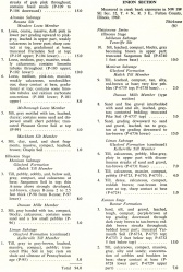
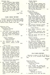
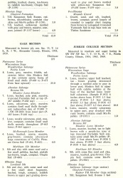
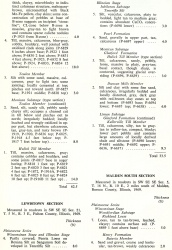
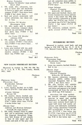
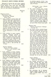
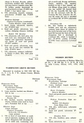
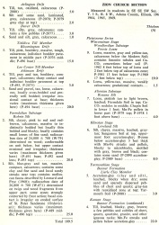
Other stratigraphic sections in this report (table 6) also describe the Sangamon Soil. In-situ profiles in till are described in the Campbells Hump, Cottonwood School, Farm Creek, Flat Rock, Jubilee College, Pulleys Mill, Tindall School, Toulon, and Washington Grove Sections. In-situ profiles developed in Teneriffe Silt are described in the Enion, New Salem Northeast, Pleasant Grove School, and Washington Grove Sections, and others developed in Loveland Silt are described in the Gale and Zion Church Sections.
| Table 6 -- Stratigraphic Sections (partial) The following 21 stratigraphic sections describe exposures in Illinois and illustrate many of the aspects of Pleistocene stratigraphy. These sections contain the type localities for 21 rock-stratigraphic units, 4 soil-stratigraphic units, and 3 time-stratigraphic units and include paratypes for several other units. The sample numbers preceded by "P" are the numbers used in the Illinois State Geological Survey collections. Analytical data on many of these samples are on file at the Survey. The sections are arrange alphabetically by name. |
Reference author(s)
Reference status
Stratigraphic relationships
Sangamon Soil has been described as an in-situ profile developed not only on Illinoian deposits including tills, Teneriffe Silt, Loveland Silt, and the Pearl Formation, but also on bedrock shale units of Pennsylvanian age (Lone Oak Section, table 7) and dolomites and sandstones as old as Ordovician age (Henze School, Wolf Creek Sections, table 7). Sangamon Soil accretion-gleys have been studied at dozens of localities, and their mineralogy has been examined in detail (Frye, Willman, and Glass, 1960; Willman, Glass, and Frye, 1966).
Extent and thickness
The Sangamon Soil as an in-situ profile on till is generally more deeply and strongly developed in southern Illinois (e.g., Pulleys Mill, table 6) than it is in central Illinois (Funkhouser and Hipple School Sections, table 7; Jubilee College and Tindall School Sections, table 6) or in northern Illinois (Damascus East, Haldane West, Kewanee North Sections, table 7). The in-situ profiles in till generally display moderately good drainage and are red-brown, but at some places (e.g., Fairview, New City Sections, table 7) the profiles in till are poorly drained and are dark gray to gray-brown. The depth of leaching diminishes somewhat northward, but the change in profile characteristics across the 400-mile north-to-south distance is not as great as would be expected from the present range in climate across this distance.
Lithology
As an in-situ profile on silt (Loveland and Teneriffe Silts) the Sangamon Soil is deeper, better drained, redder, and more massive (e.g., Pleasant Grove School Section, table 6; Mt. Carroll North, Siloam West Sections, table 7) than in profiles developed on till. The same generalization is true for Sangamon Soil developed on the Pearl Formation (e.g., Lost Prairie, Mt. Carroll South, Pearl Prairie Sections, table 7). Sangamon Soil profiles developed on bedrock (e.g., Lone Oak Section, table 7) are generally relatively thin but intensely developed.
Sangamon Soil accretion-gley (Berry Clay Member), through the years, has been the most widely recognized and described soil type, and it formerly was referred to as "gumbotil." Accretion-gley occurs on the Sterling Till Member (Coleta, Red Birch School Sections, table 7), the Ogle Till Member (Lanark East Core Section, Frye et al., 1969), the Hulick Till Member (Fairview, Hipple School Sections, table 7), the Vandalia Till Member (Effingham, Funkhouser East, Jewett, Panama-A, Ramsey Creek Sections, table 7), and the Kellerville Till Member (Rapids City (B) Section, table 7) of the Glasford Formation. Even though these tills range from early to late Illinoian in age and the localities range geographically through two thirds of the dimensions of the state, no significant differences have been detected in the character of the accretion-gley. Detailed mineralogical studies have been reported for the accretion-gley at the Effingham, Fairview, Hipple School, and other sections (Frye, Willman, and Glass, 1960; Willman, Glass, and Frye, 1966). In contrast to the in-situ Sangamon Soil, the accretion-gley profiles are not sharply defined at the top. This appears to be the result of the persistence of the poor drainage and gleying conditions after the end of Sangamonian time, with the resultant incorporation of the slowly deposited early Wisconsinan sediments into the gleyed material (Bunker Hill Section, Macoupin County, table 7). At a few places (e.g., Panama-A Section, table 7) stratigraphic differentiation can be observed within the accretion-gley deposit. Also, in some exposures (e.g., Hipple School Section, table 7) the margin of the lens of accretion-gley shows the shallow topographic depressions in which the material accumulated and the continuity with the in-situ Sangamon Soil developed on till at slightly higher positions.
Core(s)
Photograph(s)
Contacts
Well log characteristics
Fossils
Age and correlation
Environments of deposition
Economic importance
Remarks
References
FRYE, J. C. (et al.), H. D. GLASS, J. P. KEMPTON, and H. B. WILLMAN, 1969, Glacial tills of northwestern Illinois: Illinois State Geological Survey Circular 437, 47 p.
FRYE, J. C, and H. B. WILLMAN, 1963b, Loess stratigraphy, Wisconsinan classification and accretion-gleys in central western Illinois: Midwestern Section Friends of the Pleistocene, 14th Annual Meeting, Illinois State Geological Survey Guidebook Series 5, 37 p.
FRYE, J. C, H. B. WILLMAN, and H. D. GLASS, 1960, Gumbotil, accretion-gley, and the weathering profile: Illinois State Geological Survey Circular 295, 39 p.
LEVERETT, FRANK, 1898b, The weathered zone (Sangamon) between the Iowan loess and Illinoian till sheet: Journal of Geology, v. 6, p. 171-181.
WILLMAN, H. B., H. D. GLASS, and J. C. FRYE, 1966, Mineralogy of glacial tills and their weathering profiles in Illinois. Part II— Weathering profiles: Illinois State Geological Survey Circular 400, 76 p.
WORTHEN, A. H., 1873b, Geology of Sangamon County, in A. H. Worthen, Geology and palaeontology: Illinois Geological Survey, Vol. V, p. 306-319.
ISGS Codes
| Stratigraphic Code | Geo Unit Designation |
|---|---|
