Historical:Snider Till Member
Lithostratigraphy: Snider Till Member
Chronostratigraphy: Cenozoic Erathem >>Quaternary System >>Pleistocene Series
Authors
John C. Frye and H. B. Willman
Name Origin
The Snider Till Member of the Wedron Formation (Johnson et al., 1971, p. 204) is named for Snider, Vermilion County.
Type Section
The type section is in the Emerald Pond Section (NE SW SW 33, 20N-12W) (Johnson et al., 1972, p. 42).
Extent and Thickness
In the type section the member is 16 feet thick.
Stratigraphic Position
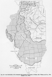
It occurs in central eastern Illinois (fig. Q-5), where it overlies the Batestown Till Member and is commonly overlain by thin Richland Loess. The uppermost part of the Snider Till is leached and within the B-horizon of the Modern Soil.
Description
In the type section, it consists of light olive-brown to gray-brown, calcareous, blocky, jointed, clayey till and a basal zone of silt, sand, and gravel.
References
JOHNSON, W. H., L. R. FOLLMER, D. L. GROSS, and A. M. JACOBS, 1972, Pleistocene stratigraphy of east-central Illinois: Illinois State Geological Survey Guidebook Series 9, 97 p.
JOHNSON, W. H., D. L. GROSS,and S. R. MORAN, 1971, Till stratigraphy of the Danville region, east-central Illinois; in Till- a symposium: Ohio State University Press. p.
184-216; Illinois State Geological Survey Reprint 1972-I.
ISGS Codes
| Stratigraphic Code | Geo Unit Designation |
|---|---|

