Galatia Channel:Other Channels
Other Channels
Potter (1962[1], 1963[2]) mapped other channel-form sandstone bodies below the Springfield Coal that do not correspond to interruptions in the coal. These include a series of branching, strongly meandering channels in southern Illinois, largely Franklin, Hamilton, Saline, and Gallatin Counties (Figure 8). Widths are in the range of 0.6 to 1.9 mi (1 to 3 km). Portions appear dendritic with tributaries, but the overall drainage direction is unclear. These likely represent more than one channel; one segment appears to cross the Galatia channel at nearly a right angle. More channels mapped by Potter are in Bond, Clinton, Washington, and Perry Counties of southwestern Illinois. These sinuous features branch and rejoin but do not exhibit (as mapped) an integrated drainage. We have not investigated these channels and will offer no further comments.

Friedman (1956[5], 1960[6]) mapped an area near Terre Haute, Indiana, where the Springfield Coal is split and partly replaced by sandstone and shale. He called this feature the Terre Haute channel. Friedman’s map (Figure 38) shows a southwest-trending channel about 1,300 ft (400 m) wide, with several short branches joining from the southeast. In one area, the coal divides into a continuous lower bench and an upper bench that thins and pinches out toward the channel axis. In another area, shale layers occur in the coal along a linear trend, although the coal is not cut out. Sandstone is largely confined to the main channel. Maximum clastic thickness is about 40 ft (12 m). Harper (1985, p. 19–20)[7] discussed the Terre Haute channel in relation to the Dresser underground coal mine but did not shed further light on the nature of the disturbance. Friedman (1956[5], 1960[6]) inferred a dendritic fluvial system that was active during later stages of peat formation. The Terre Haute channel may be similar to the Leslie Cemetery channel, but not enough data are at hand to offer a theory of its origin.
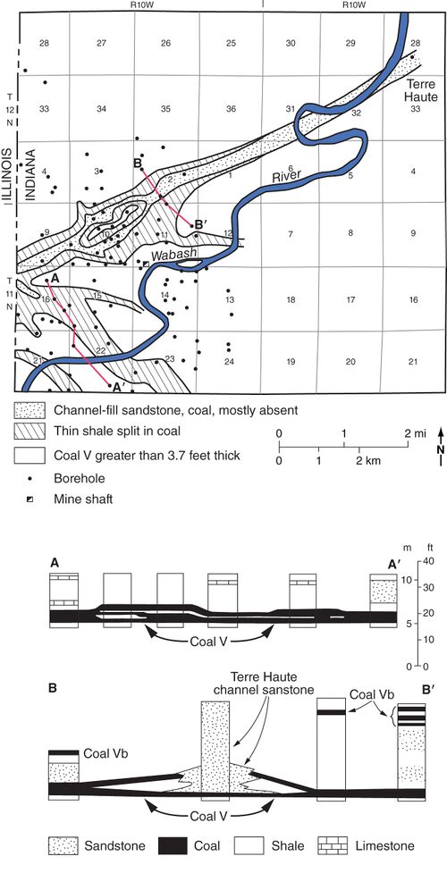 Figure 38 Map and cross section of the Terre Haute channel. From Friedman (1960)[8]. Courtesy of the Indiana Geological and Water Survey. Lines of cross section are shown on the map.

Primary Source
References
- ↑ Potter, P.E., 1962, Shape and distribution patterns of Pennsylvanian sand bodies in Illinois: Illinois State Geological Survey, Circular 339, 36 p., 3 pls.
- ↑ Potter, P.E., 1963, Paleozoic sandstones of the Illinois Basin: Illinois State Geological Survey, Report of Investigations 217, 92 p., 1 pl.
- ↑ Potter, P.E., 1962, Shape and distribution patterns of Pennsylvanian sand bodies in Illinois: Illinois State Geological Survey, Circular 339, 36 p., 3 pls.
- ↑ Hopkins, M.E., 1968, Harrisburg (No. 5) Coal reserves of southeastern Illinois: Illinois State Geological Survey, Circular 431, 25 p., 2 pl.
- ↑ a b Friedman, S.A., 1956, Split and channel sandstone in Coal V in the Dresser area, Vigo County, Indiana: Proceedings of the Indiana Academy of Science for 1955, v. 65, p. 165–168.
- ↑ a b Friedman, S.A., 1960, Channel-fill sandstones in the Middle Pennsylvanian rocks of Indiana: Indiana Geological Survey, Report of Progress No. 23, 59 p.
- ↑ Harper, D., 1985, Coal mining in Vigo County, Indiana: Indiana Geological Survey, Special Report 34, 67 p.
- ↑ Friedman, S.A., 1960, Channel-fill sandstones in the Middle Pennsylvanian rocks of Indiana: Indiana Geological Survey, Report of Progress No. 23, 59 p.