Galatia Channel:Introduction
Introduction
Since the late 1960s, geologists working in the Illinois Basin have recognized that deposits of thick coal having a relatively low sulfur content (<2%) are associated with thick, nonmarine gray mudstone and siltstone overlying the coal.
Moreover, these thick, gray sediments are associated with paleochannels that existed during peat formation. Channels contemporaneous with the Herrin and Springfield Coals, the two most important economic seams in the basin, have been identified and mapped in detail. Similar relationships involving the Murphysboro, Colchester, Baker, and Danville Coals also have been documented (Treworgy and Jacobson 1979)[1].
Previous authors have explained these relationships by using a model based on the modern Mississippi delta. They envisioned a channel that periodically broke through its natural levees and discharged sediment-laden water into flanking peat swamps. The resulting “crevasse splays” created clastic “splits” within the peat along the channel margins. However, no natural levees have been found along the paleochannels, significant evidence exists for tidal sedimentation, and further research has shown that the Mississippi delta is probably not a good analogue for Pennsylvanian coal deposits. Hence, the model needs revision.
This study describes and explains the Galatia channel, one of the best-known examples of a paleochannel contemporaneous with peat accumulation. Such paleochannels yield key insights into the ways eustasy and climate influence sedimentation, and they add complexity to generalized models of cyclic sedimentation. A new model is presented here, which takes in the complete history of development of the Galatia channel and the landscapes of which it was a part. This model is then applied to other paleochannels in the Illinois Basin, and likely can be applied in other basins.
Geologic Setting
The Illinois Basin, also called the Eastern Interior Basin, covers much of Illinois along with southwestern Indiana and part of western Kentucky in the east-central United States (Figure 1). The Illinois Basin is an interior cratonic basin that developed progressively throughout Paleozoic time (Leighton et al. 1991)[2]. During the Pennsylvanian Period, widespread tectonic deformation took place in the Illinois Basin in response to the Ancestral Rocky Mountains orogeny (McBride and Nelson 1998)[3] and perhaps flexural interactions with the Allegheny orogeny (Quinlan and Beaumont 1984)[4]. In Illinois, the La Salle Anticlinorium, Du Quoin Monocline, Salem and Louden Anticlines, and numerous smaller structures all were active during the Pennsylvanian. In fact, the Springfield Coal thins where it crosses the Louden Anticline and the southern part of the La Salle Anticlinorium (Plate 1), evidence that these structures were rising during peat accumulation.
-
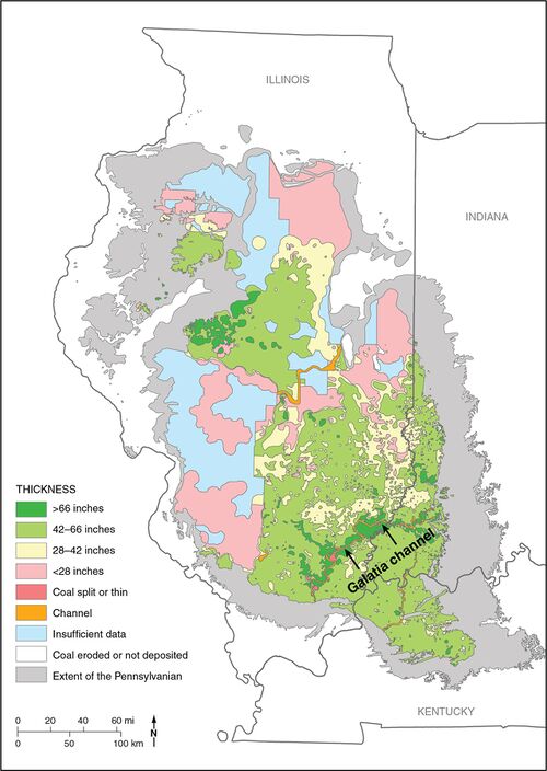 Figure 1 Map of the Illinois Basin showing the extent of Pennsylvanian rocks, thickness of the Springfield Coal, and channels interrupting the coal. From Finley et al. (2005)[5]. Straight lines separating polygons are artifacts of mapping protocol in original.


On a global scale, assembly of the supercontinent of Pangaea was well underway by the Middle Pennsylvanian. Southwest of the Illinois Basin, plate collision had closed off the Arkoma Basin, and the Ouachita Mountains were rising (Houseknecht 1983)[6]. Tectonic activity was widespread throughout the Midcontinent, including the Illinois Basin (McBride and Nelson 1998)[3]. Plate reconstructions show the Illinois Basin close to, or slightly south of, the equator (Scotese 2010[7]; Blakey 2011[8]).
The Springfield Coal Member[footnote 1] of the Carbondale Formation is of late Desmoinesian age (Figure 2), which is equivalent to the Asturian (Westphalian D) of Western Europe and to late Moscovian on the global time scale (Davydov et al. 2012[9]). It is informally known as No. 5 Coal in Illinois, Coal V in Indiana, and No. 9 Coal in western Kentucky. The Springfield is correlative with the Summit Coal of the Western Interior Basin and with the Middle Kittanning coal bed of the northern Appalachian Basin on the basis of physical stratigraphy (Wanless 1939),[10] palynology of the coal (Peppers 1996)[11] and conodonts (Heckel 2009) [12]and ammonoids (Work et al. 2009)[13] in associated marine rocks.
-
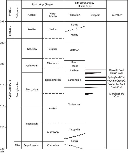 Figure 2 Correlation chart showing the positions of key units within the Pennsylvanian Subsystem. Global and provincial stage boundaries and ages in millions of years (Ma) are after Gradstein et al. (2012)[14].

The Springfield accounts for about 29% of remaining identified Illinois Basin resources and has been the most extensively mined coal seam in the Illinois Basin (Hatch and Affolter 2002)[15]. The coal is high-volatile bituminous in rank and generally is bright-banded, having well developed cleat and lacking significant clastic partings. Thickness varies from about 3.9 to 4.9 ft (1.2 to 1.5 m) in most areas where the coal has been mined. Thicker coal, locally exceeding 9.8 ft (3 m), is confined to the flanks of the Galatia channel.
Previous Research
With their eyes on industrial development, the scientists who made the first geological surveys of Illinois, Indiana, and Kentucky paid special attention to coal deposits. David Dale Owen first described what is now called the Springfield Coal in Indiana (1859)[16] and in Kentucky (1856)[17]; Amos Worthen did the same in Illinois (1870)[18]. Gilbert H. Cady (1919, p. 21)[19] may have been the first to remark on a sandstone which occupies what seems to have been a channel running southward through the central part of the district in the west side of Raleigh and Harrisburg Townships (Ts. 8 and 9 S., R. 6 E.) [Saline County, Illinois]. This channel was apparently formed and filled before the deposition of No. 6 coal and probably during or after the deposition of No. 5 coal.
The extent of the channel north of Saline County in Illinois remained little known because the greater depth of the coal deterred mining. Over the next 50 years, other authors briefly remarked on aspects of what came to be known as the Galatia channel. Mining companies coped with channel-related features and recorded them on their maps. But until 1968, these features were known only as isolated phenomena.
Hopkins’s (1968)[20] report on resources of the Springfield Coal made a break-through. Using mainly electric logs from oil test holes, Hopkins mapped the coal in areas where no mining or coal exploration had taken place. Hopkins also employed the Illinois State Geological Survey’s extensive database of coal quality analyses. His key findings remain essentially valid today:
- Clastic rocks replace the Springfield Coal along a southwest-trending, meandering tract across southeastern Illinois, averaging about 0.6 mi (1 km) wide. Hopkins (1968, p. 1)[20] characterized this feature (then unnamed) as a channel “believed to be in part contemporaneous with the coal."
- Coal is abnormally thin or “split” with layers of rock close to channel margins..
- The thickest coal occurs close to the channel.
- Gray silty shale (Dykersburg Shale Member) directly overlies the coal along the channel.
- Where the Dykersburg is thicker than 19.7 ft (6 m), the Springfield Coal has a lower than normal sulfur content (2.5% or less).
Hopkins (1968)[20] presented little geologic interpretation, aside from proposing that the channel existed during peat formation and that rapid burial by nonmarine gray mud (Dykersburg) shielded the peat from sulfur-bearing marine water and sediments.
A series of reports (Gluskoter and Simon 1968[21]; Gluskoter and Hopkins 1970[22]; Allgaier and Hopkins 1975[23]; Hopkins et al. 1979[24]; Jacobson 1983[25]) rapidly followed, augmenting Hopkins’s initial findings, developing an interpretive model, and outlining similar relationships for areas of low-sulfur coal bordering paleochannels in other Illinois coal seams. Hopkins et al. (1979, p. 148)[24] proposed the name “Galatia channel,” taking the name of a small community near the feature in Saline County, Illinois.
In Indiana, Donald L. Eggert (1978)[26] was the first to recognize paleochannels contemporaneous with the Springfield Coal. A series of follow-up papers and reports (Eggert 1982[27], 1984[28], 1994[29]; Eggert and Adams 1985[30]) described the Galatia channel and related features in Gibson, Pike, and Warrick Counties. Together, these articles described relationships closely similar to those developed in Illinois, and they relied on the same interpretive crevasse-splay model.
Crevasse-Splay Model
Models applying modern deltaic processes to ancient rocks (e.g., Morgan and Shaver 1970[31]) were in vogue when the Galatia channel was first recognized. Being close at hand and thoroughly investigated, the Mississippi delta commanded the attention of American geologists. Explicitly or otherwise, authors had the Mississippi delta in mind as they explained coal-contemporaneous channels in the Illinois Basin. Leading the way were Johnson (1972)[32] and Allgaier and Hopkins (1975)[23]. Hopkins et al. (1979)[24] referred to the Dykersburg and Energy Shales as crevasse-splay deposits derived from those channels. Summarizing earlier work, Nelson (1983, figure 8)[33] illustrated Galatia channel environments, including levees, crevasse splays, and a bird-foot delta like that of the Mississippi (Figure 3). Nelson et al. (1987, p. 12–14)[34] departed slightly from previous scenarios, noting the lack of evidence for natural levees while continuing to place the coal and shale deposits within an overall deltaic setting. Similarly, Burk et al. (1987)[35] continued to interpret the origin of the Energy Shale in terms of deltaic crevasse splays.

Eggert (1982)[27] and Eggert and Adams (1985)[30] also explicitly related channel development in Indiana to the modern Mississippi delta. They envisioned the Galatia and associated channels as deltaic distributaries flanked by natural levees that frequently failed, spilling sediment-laden water into adjoining peat swamps. Eggert (1994)[29] regarded the Galatia channel as part of a delta that prograded seaward during peat deposition (p. 14) and alluded to the Dykersburg Shale as lacustrine and overbank mud (p. 16).
Archer and Kvale (1993)[36] and Archer et al. (1994[37], 1995[38]) represent the first major departure from the deltaic model in the Illinois Basin. These authors recognized rhythmic lamination and other tidal signatures in Illinois gray shale associated with low-sulfur coal. Thus, they placed deposits such as the Dykersburg Shale into estuarine environments rather than fluvially dominated deltas.
Cyclicity and Sequence Stratigraphy
The Illinois Basin is the birthplace of the cyclothem. Udden (1912)[39] recognized four cycles of deposition in Middle Pennsylvanian rocks near Peoria, Illinois; the oldest cycle included Coal No. 5 (Springfield). Weller (1930)[40] introduced “cyclical formations”; Wanless and Weller (1932)[41] coined the term “cyclothem” based mainly on work in western Illinois. By this time, other workers had recognized Pennsylvanian cycles elsewhere in the United States. Among the driving mechanisms suggested were interrupted subsidence, tectonic movements, and autogenic processes such as channel avulsion and delta switching (Langenheim and Nelson 1992)[42]. Wanless and Shepard (1935[43], 1936[44]) were the first to propose glacially driven eustatic changes of sea level as the driving process.
Sequence stratigraphy came into use within the oil industry in the 1970s and reached the broader geologic community with American Association of Petroleum Geologists’ Memoir 26 (Payton 1977)[45]. However, Sloss et al. (1949)[46], who worked in Illinois, are acknowledged as pioneers. Basically, a sequence is an updated version of the cyclothem, with glacial eustasy viewed as the primary causative mechanism. A sequence is “a relatively conformable succession of genetically related strata bounded at its top and base by unconformities or their correlative conformities” (Mitchum 1977, p. 210)[47] and represents a single cycle of sea-level rise and fall. Modern sequence stratigraphers recognize as many as five orders or levels of cyclicity and relate them to periodic changes in the earth’s climate caused by astronomical processes.
In the past 40 years, sequence stratigraphers have generated an immense amount of literature accompanied by a maze of terminology. A brief review revealed that different authors apply some of the same terms with different meanings. Ironically, sequence stratigraphy has yet to see much usage in its original homeland, the Illinois Basin. Full application of sequence concepts to Pennsylvanian rocks in this basin is beyond the scope of this report. Nevertheless, we wish to discuss rocks related to the Springfield Coal and Galatia channel in terms of their interpreted position in eustatic cycles. To avoid misunderstanding, we are using terms in the following fashion:
- Lowstand: an episode when sea level was at its lowest, corresponding to the maximum extent of continental glaciers.
- Transgression: an episode when sea level was rising in response to the melting of continental glaciers (deglaciation).
- Highstand: an episode when sea level was highest, correlating to the maximum deglaciation.
- Regression: an episode of falling sea level related to the growth of continental glaciers.
Notes
- ↑ Classification differs among the three state geological surveys. Indiana and Illinois regard the Springfield as a formal member, whereas Kentucky classifies all coals informally as beds
Primary Source
References
- ↑ Treworgy, C.G., and R.J. Jacobson, 1979, Paleoenvironments and distribution of low-sulfur coal in Illinois, in A.T. Cross, ed., Economic geology: Coal, oil and gas: Ninth International Congress on Carboniferous Stratigraphy and Geology, Proceedings, v. 4: Carbondale, Southern Illinois University Press, p. 349–359.
- ↑ Leighton, M.W., D.R. Kolata, D.F. Oltz, and J.J. Eidel, 1991, Interior cratonic basins: American Association of Petroleum Geologists, Memoir 51, 819 p.
- ↑ a b McBride, J.H., and W.J. Nelson, 1998, Style and origin of mid-Carboniferous deformation in the Illinois Basin, USA—Ancestral Rockies deformation: Tectonophysics, v. 305, p. 249–273.
- ↑ Quinlan, G.M., and C. Beaumont, 1984, Appalachian thrusting, lithospheric flexure, and the Paleozoic stratigraphy of the Eastern Interior of North America: Canadian Journal of Earth Science, v. 21, no. 9, p. 973–996.
- ↑ Finley, R., and Midwest Geological Sequestration Consortium, 2005, An assessment of geological carbon sequestration options in the Illinois Basin: Illinois State Geological Survey, final report to U.S. Department of Energy, contract DE-FC26-03NT41994, 477 p.
- ↑ Houseknecht, D.W., ed., 1983, Tectonic– sedimentary evolution of the Arkoma Basin: SEPM (Society for Sedimentary Geology), Midcontinent Section, v. 1, 119 p.
- ↑ Scotese, C.R., 2010, Plate tectonic maps and continental drift animations, Late Carboniferous (306 Ma): http://www. scotese.com/late.htm (accessed April 24, 2013).
- ↑ Blakey, R., 2011, North American paleogeographic maps, Late Pennsylvanian (300 Ma): Flagstaff, Northern Arizona University, https://www2.nau.edu/rcb7/ (accessed October 20, 2020). New version available at https://deep-timemaps.com.
- ↑ Davydov, V.I., D. Korn, and M.D. Schmitz, 2012, The Carboniferous Period, in F.M. Gradstein, J.G. Ogg, M.D. Schmitz, and G.M. Ogg, eds.,The geologic time scale 2012, v. 2: Amsterdam, Elsevier, p. 603–651.
- ↑ Wanless, H.R., 1939, Pennsylvanian correlations in the Eastern Interior and Appalachian coal fields: Geological Society of America, Special Paper 17, 130 p.
- ↑ Peppers, R.A., 1996, Palynological correlation of major Pennsylvanian chronostratigraphic boundaries in the Illinois and other coal basins: Geological Society of America, Memoir 188, 111 p. and chart.
- ↑ Heckel, P.H., 2009, Pennsylvanian cyclothems in Midcontinent North America as far-field effects of waxing and waning of Gondwana ice sheets: Geological Society of America, Special Paper 441, p. 275–289.
- ↑ Work, D.M., C.E. Mason, and R.H. Mapes, 2009, The Pennsylvanian ammonoid succession in the Appalachian basin, in S.F. Greb and D.R. Chesnut Jr., eds., Carboniferous of the Appalachian and Black Warrior Basins: Kentucky Geological Survey, Series 12, Special Publication 10, p. 71–77.
- ↑ Gradstein, F.M., J.G. Ogg, M.D. Schmitz, and G.M. Ogg, 2012, The geologic time scale 2012, 1st ed.: Amsterdam, Elsevier, 1,144 p.
- ↑ Hatch, J.R., and R.H. Affolter, 2002, Resource assessment of the Springfield, Herrin, Danville, and Baker Coals in the Illinois Basin: U.S. Geological Survey, Professional Paper 1625-D, https://doi.org/10.3133/pp1625D.
- ↑ Owen, D.D., 1859, Report of a geological reconnaissance of the State of Indiana made in the year 1837, Part First: Bloomington, John C. Walker/Indiana Geological Survey, 69 p.
- ↑ Owen, D.D., 1856, Report on the geological survey in Kentucky made during the years 1854 and 1855: Kentucky Geological Survey Bulletin, Series 1, v. 1, 416 p.
- ↑ Worthen, A.H., 1870, Geology and paleontology: Geological Survey of Illinois, v. 4, 508 p.
- ↑ Cady, G.H., 1919, Coal resources of District V (Saline and Gallatin Counties): State Geological Survey, Cooperative Mining Series Bulletin 19, 135 p., 9 pls.
- ↑ a b c Hopkins, M.E., 1968, Harrisburg (No. 5) Coal reserves of southeastern Illinois: Illinois State Geological Survey, Circular 431, 25 p., 2 pl.
- ↑ Gluskoter, H.J., and J.A. Simon, 1968, Sulfur in Illinois coals: Illinois State Geological Survey, Circular 432, 28 p.
- ↑ Gluskoter, H.J., and M.E. Hopkins, 1970, Distribution of sulfur in Illinois coals: Illinois State Geological Survey, Guidebook Series 8, p. 89–95.
- ↑ a b Allgaier, G.J., and M.E. Hopkins, 1975, Reserves of the Herrin (No. 6) Coal in the Fairfield Basin in southeastern Illinois: Illinois State Geological Survey, Circular 489, 31 p., 2 pls.
- ↑ a b c Hopkins, M.E., R.B. Nance, and C.G. Treworgy, 1979, Mining geology of Illinois coal proto-Precordillera, Argentina deposits, in J.E. Palmer and R.R. Dutcher, Depositional and structural history of the Pennsylvanian System in the Illinois Basin, Part 2: Invited papers: Ninth International Congress of Carboniferous Stratigraphy and Geology: Illinois State Geological Survey, Field Trip 9, p. 142–151.
- ↑ Jacobson, R.J., 1983, Murphysboro Coal, Jackson and Perry Counties: Resources with low to medium sulfur potential: Illinois State Geological Survey, Illinois Mineral Notes 85, 19 p.
- ↑ Eggert, D.L., 1978, A distributary channel contemporaneous with deposition of the Springfield Coal member (V), Petersburg Formation (Pennsylvanian) in Warrick County, Indiana: Geological Society of America, Abstracts with Programs, v. 10, p. 395.
- ↑ a b Eggert, D.L., 1982, A fluvial channel contemporaneous with deposition of the Springfield Coal Member (V), Petersburg Formation, northern Warrick County, Indiana: Indiana Geological Survey, Special Report 28, 20 p.
- ↑ Eggert, D.L., 1984, The Leslie Cemetery and Francisco distributary fluvial channels in the Petersburg Formation (Pennsylvanian) of Gibson County, Indiana, U.S.A., in R.A. Rahmani and R.M. Flores, eds., Sedimentology of coal and coal-bearing sequences: International Association of Sedimentologists, Special Publication 7, p. 309–315.
- ↑ a b Eggert, D.L., 1994, Coal resources of Gibson County, Indiana: Indiana Geological Survey, Special Report 50, 36 p., 1 pl.
- ↑ a b Eggert, D.L., and S.C. Adams, 1985, Distribution of fluvial channel systems contemporaneous with the Springfield Coal Member (Middle Pennsylvanian) in southwestern Indiana, in A.T. Cross, ed., Economic geology: Coal, oil and gas: Ninth International Congress of Carboniferous Geology and Stratigraphy, Proceedings, v. 4: Carbondale, Southern Illinois University Press, p. 342–348.
- ↑ Morgan, J.P., and R.H. Shaver, eds., 1970, Deltaic sedimentation, modern and ancient: Society of Economic Paleontologists and Mineralogists, Special Publication 15, 312 p.
- ↑ Johnson, D.O., 1972, Stratigraphic analysis of the interval between the Herrin (No. 6) Coal and the Piasa Limestone in southwestern Illinois: Urbana, University of Illinois, Ph.D. thesis, 105 p.
- ↑ Nelson, W.J., 1983, Geologic disturbances in Illinois coal seams: Illinois State Geological Survey, Circular 530, 47 p.
- ↑ Nelson, W.J., P.J. DeMaris, and R.A. Bauer, 1987, The Hornsby district of low-sulfur Herrin Coal in central Illinois (Christian, Macoupin, Montgomery, and Sangamon Counties): Illinois State Geological Survey, Circular 540, 40 p., 1 pl.
- ↑ Burk, M.K., M.P., Deshowitz, and J.E. Utgaard, 1987, Facies and depositional environments of the Energy Shale Member (Pennsylvanian) and their relationship to low-sulfur coal deposits in southern Illinois: Journal of Sedimentary Petrology, v. 57, no. 6, p. 1060–1067.
- ↑ Archer, A.W., and E.P. Kvale, 1993, Origin of gray shale lithofacies (clastic wedges) in U.S. Midcontinent coal measures (Pennsylvanian): An alternate explanation: Geological Society of America, Special Paper 286, p. 181–192.
- ↑ Archer, A.W., H.R. Feldman, E.P. Kvale, and W.P. Lanier, 1994, Comparison of drier- to wetter-interval estuarine roof facies in the Eastern and Western Interior coal basins, USA: Palaeogeography, Palaeoclimatology, Palaeoecology, v. 106, p. 171–185.
- ↑ Archer, A.W., G.J. Kuecher, and E.P. Kvale, 1995, The role of tidal-velocity asymmetries in the deposition of silty tidal rhythmites (Carboniferous, Eastern Interior Coal Basin, U.S.A.): Journal of Sedimentary Research, v. 65A, p. 408–416.
- ↑ Udden, J.A., 1912, Geology and mineral resources of the Peoria Quadrangle: U.S. Geological Survey, Bulletin 506, 103 p.
- ↑ Weller, J.M., 1930, Cyclical sedimentation of the Pennsylvanian Period and its significance: Journal of Geology, v. 38, p. 97–135.
- ↑ Wanless, H.R., and J.M. Weller, 1932, Correlation and extent of Pennsylvanian cyclothems: Geological Society of America Bulletin, v. 43, p. 1003–1016.
- ↑ Langenheim, R.H., and W.J. Nelson, 1992, The cyclothemic concept in the Illinois Basin: A review, in R.H. Dott Jr., ed., Eustasy: The historical ups and downs of a major geological concept: Geological Society of America, Memoir 180, p. 55–71.
- ↑ Wanless, H.R., and F.P. Shepard, 1935, Permo-Carboniferous coal series related to Southern Hemisphere glaciation: Science, v. 81, p. 521–522.
- ↑ Wanless, H.R., and F.P. Shepard, 1936, Sea level and climatic changes related to late Paleozoic cycles: Geological Society of America Bulletin, v. 47, p. 1177–1206.
- ↑ Payton, C.F., ed., 1977, Seismic stratigraphy—Applications to hydrocarbon exploration: American Association of Petroleum Geologists, Memoir 26, v. 11, 516 p.
- ↑ Sloss, L.L., W.C. Krumbein, and E.C. Dapples, 1949, Integrated facies analysis, in C.R. Longwell, ed., Sedimentary facies in geologic history: Geological Society of America, Memoir 39, p. 91–124.
- ↑ Mitchum, R.M., 1977, Seismic stratigraphy and global changes of sea level, part 11: Glossary of terms used in seismic stratigraphy, in C.E. Payton, ed., Seismic stratigraphy—Applications to hydrocarbon exploration: American Association of Petroleum Geologists, Memoir 26, v. 11, p. 205–212.