Galatia Channel:Effingham Channel
Effingham Channel
Across most of the basin, the upward-coarsening Delafield Member underlies the Springfield Coal. However, Potter’s (1962[1], 1963[2]) maps depict several large meandering and dendritic sand bodies, evidently paleochannels, that replace the Delafield Member below the Springfield Coal. The largest of these paleochannels trends southeast from central Illinois to southwestern Indiana (Figures 1 and 8; Plate 1). This feature is hereby named the Effingham channel after the city of Effingham, Illinois, which lies near its course. Comparing Potter’s map (Figure 30) with those of Hopkins (1968)[3], Treworgy and Bargh (1984)[4], and Treworgy et al. (1999)[5], we observed the following:
| * | The Effingham channel widens toward the southeast, and several tributaries are “barbed” toward the northwest. Thus, it evidently flowed southeast. |
| * | The Effingham channel crosses the southwest-trending Galatia channel at a right angle. |
| * | The Effingham channel does not interrupt the Springfield Coal, and the coal does not appreciably thicken along its margins. |
| * | The Effingham channel exhibits meander-belt geometry (in map view) similar to the Galatia channel. |
| * | No Dykersburg Shale is associated with the Effingham channel. |
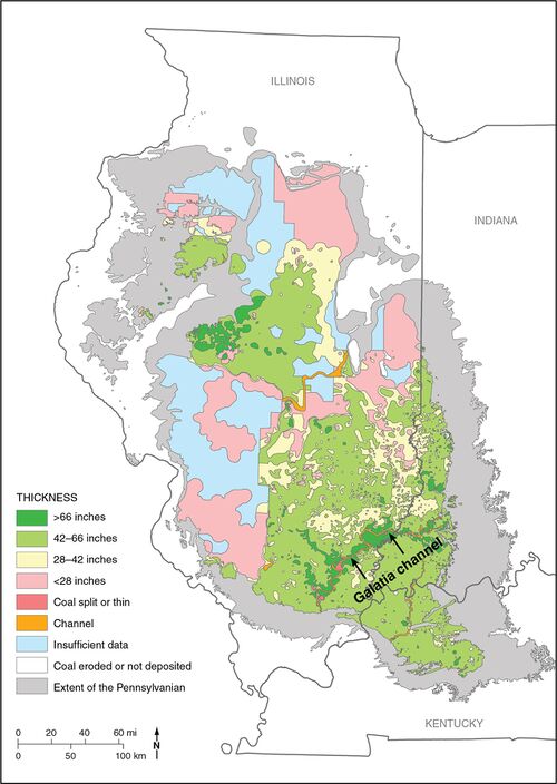 Figure 1 Map of the Illinois Basin showing the extent of Pennsylvanian rocks, thickness of the Springfield Coal, and channels interrupting the coal. From Finley et al. (2005)[6]. Straight lines separating polygons are artifacts of mapping protocol in original.
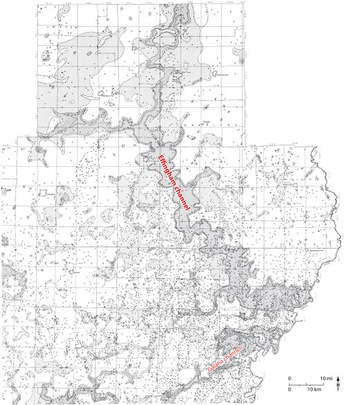


Cross sections (Plate 4, Plate 4 map overview and Plate 5, Plate 5 map overview) show that the Effingham channel, like the Galatia, has a wide, nearly flat bottom and steep sides. The base is cut close to the Houchin Creek Coal. Many wireline logs indicate two sedimentary sequences filling the Effingham channel. The lower sequence is largely sandstone, fining upward and ranging from about 20 to 50 ft (6 to 15 m) thick. A few logs show a thin, highly resistive bed at the top of the lower sequence. A density–neutron log (Figure 31) from the Berry Petroleum No. 11-14 Pitcher well in Jasper County confirms that the resistive bed is coal. The upper sequence is 20 to 30 ft (6 to 9 m) thick and is mostly shale and siltstone. In some cases, the sequence fines upward from basal sandstone, but other logs show an upward-coarsening profile. The best record is continuous core from the ISGS No. 1 Elysium borehole in Richland County (Figure 32). The lower sequence is about 15 ft (4.5 m) thick and is largely sandstone, fining upward from an erosive lower contact. Cross-bedding in the lower part gives way to planar lamination having well-developed neap–spring tidal couplets near the top. The upper sequence is 23 ft (7 m) thick and is largely sandstone, grading to blocky, rooted claystone at the top beneath the Springfield Coal.


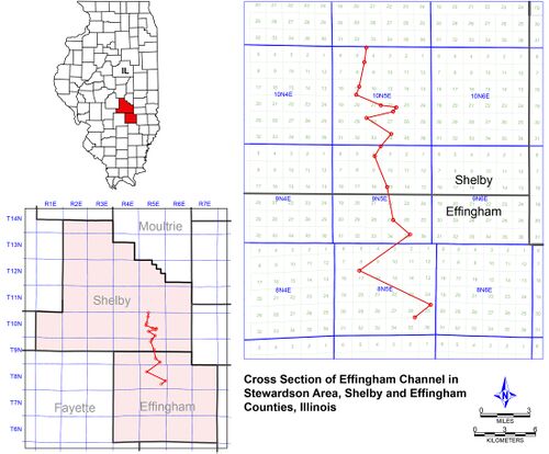 Plate 5 - Map overview Cross section of the Effingham channel near Stewardson in Effingham and Shelby Counties, Illinois
Download Full Resolution Image: HERE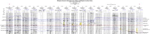 Plate 5 Cross section of the Effingham channel near Stewardson in Effingham and Shelby Counties, Illinois
Download Full Resolution Image: HERE


The Springfield Coal locally thickens above the Effingham channel, as shown on the map by Treworgy et al. (2000)[5]. This is most obvious along the west branch of the channel in southern Shelby County (Plate 5), which suggests that the channel was incompletely filled, leaving a trough to be filled with thicker peat. There is no shaly coal or other evidence for an active stream occupying the channel during the time of peat formation.
Cross-cutting relationships indicate that the Effingham channel is older than the Galatia channel (Figure 33). After establishing its meander belt, the Effingham system was abandoned and backfilled with sediment. Locally, small peat depos its developed in the abandoned waterway before a second stage of fluvial activity completed backfilling of the channel.

This scenario introduces complications into how the Effingham channel fits into eustatic cycles. A possible solution is explored in the Discussion section.
Primary Source
References
- ↑ Potter, P.E., 1962, Shape and distribution patterns of Pennsylvanian sand bodies in Illinois: Illinois State Geological Survey, Circular 339, 36 p., 3 pls.
- ↑ Potter, P.E., 1963, Paleozoic sandstones of the Illinois Basin: Illinois State Geological Survey, Report of Investigations 217, 92 p., 1 pl.
- ↑ Hopkins, M.E., 1968, Harrisburg (No. 5) Coal reserves of southeastern Illinois: Illinois State Geological Survey, Circular 431, 25 p., 2 pl.
- ↑ Treworgy, J.D., and M.H. Bargh, 1984, Coal resources of Illinois, Herrin (No. 6) Coal: Illinois State Geological Survey, 1 map sheet, 1:500,000.
- ↑ a b Treworgy, C.G., C.P. Korose, C.A. Chenoweth, and D.L. North, 1999, Availability of the Springfield Coal for mining in Illinois: Illinois State Geological Survey, Illinois Minerals 118, 43 p.
- ↑ Finley, R., and Midwest Geological Sequestration Consortium, 2005, An assessment of geological carbon sequestration options in the Illinois Basin: Illinois State Geological Survey, final report to U.S. Department of Energy, contract DE-FC26-03NT41994, 477 p.
- ↑ Potter, P.E., 1962, Shape and distribution patterns of Pennsylvanian sand bodies in Illinois: Illinois State Geological Survey, Circular 339, 36 p., 3 pls.
- ↑ Hopkins, M.E., 1968, Harrisburg (No. 5) Coal reserves of southeastern Illinois: Illinois State Geological Survey, Circular 431, 25 p., 2 pl.
- ↑ Potter, P.E., 1962, Shape and distribution patterns of Pennsylvanian sand bodies in Illinois: Illinois State Geological Survey, Circular 339, 36 p., 3 pls.