Galatia Channel:Leslie Cemetery Channel
Leslie Cemetery Channel
Eggert (1978[1], 1982[2], 1984[3], 1994[4]), Eggert and Adams (1985)[5], and Willard et al. (1995)[6] described a belt of “split” Springfield Coal in southwestern Indiana and called this feature the Leslie Cemetery channel (Figure 34). Our observations in active surface mines and those of other ISGS geologists provided further information. A revised map of the channel (Figure 35) is based on newly available data from active mines and boreholes. In addition, a cross section (Plate 6 and Plate 6 Map Overview) has been constructed using borehole data.
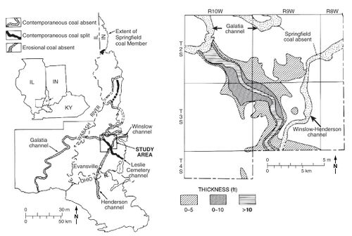 Figure 34 Maps of the Leslie Cemetery channel. (a) Regional map showing the relationship to other channels. (b) Map of the northern part of the Leslie Cemetery channel, with the thickness of the Folsomville Member. From Eggert (1984), The Leslie Cemetery and Francisco distributary fluvial channels in the Petersburg Formation (Pennsylvanian) of Gibson County, Indiana, U.S.A., in R.A. Rahmani and R.M. Flores, eds., Sedimentology of coal and coal-bearing sequences: International Association of Sedimentologists, Special Publication 7 p. 311, 313. Copyright © 1984 The International Association of Sedimentologists.


The Leslie Cemetery channel is slightly sinuous in map view and varies from about 0.9 to 3.7 mi (1.5 to 6 km) wide. It trends northwest from the outcrop in Warrick County into eastern Gibson County, where it intersects the Galatia channel. In sectional view (Plate 6 and Plate 6 Map Overview), the Leslie is lens-shaped, reaching 65 ft (20 m) thick along its central axis. Unlike the Galatia channel, the Leslie Cemetery splits the Springfield Coal, with the upper “bench” of coal overriding the clastic rocks that fill the channel (Figure 36, Plate 6 and Plate 6 Map Overview). The Turner Mine Shale and St. David Limestone directly overlie the upper coal bench.
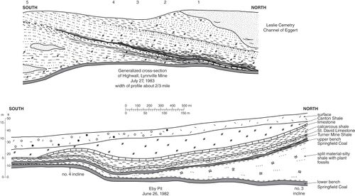 Figure 36 Generalized sketches illustrating opposite margins of the Leslie Cemetery channel, as exposed in surface mines in the eastern half of 9S, 4W, Warrick County, Indiana. The upper image is from Peabody’s Lynnville Mine in July 1983, representing the northern half of the channel. The lower image is from Peabody’s Eby Pit in June 1982, representing the southern half of the channel.


The lower bench of the Springfield Coal is generally 2 to 4 ft (0.6 to 1.2 m) thick and lacks clastic layers. Ash and sulfur content are moderate to low. In terms of petrography and palynology, the lower bench is similar to Springfield Coal elsewhere near the Galatia channel (Willard et al. 1995)[6]. The lower bench dips into a trough below the channel (Figure 36) and is nearly continuous, except in a few places where the channel truncates the coal.
Filling the Leslie channel is a succession of gray mudstone, siltstone, and fine-grained sandstone that Eggert (1982)[2] named the Folsomville Member. Near the margins of the channel, the Folsomville consists largely of nonfissile, slickensided claystone and thinly laminated, organic-rich carbonaceous shale. As the Folsomville thickens, it changes to layered gray mudstone and siltstone containing laminae and lenses of sandstone along with siderite nodules and concretions. Toward the axis of the Leslie Cemetery channel, sandstone becomes more prevalent and commonly shows cut-and-fill features. Cross-bedding is unidirectional and indicates a paleocurrent toward the northwest; no indications of tidal sedimentation have been recognized (Willard et al. 1995)[6]. Fossil plants are locally abundant in the finer grained rocks, especially prone stems and logs of lycopsids and pteridosperm foliage, along with roots of lycopsids, pteridosperms, and calamites. A rooted “seat earth” commonly occurs below the upper coal bench (Willard et al. 1995)[6]. Eggert (1982)[2] reported fossil tree stumps in growth position, and we observed several at the Cypress Creek Mine near the margin of the channel. These stumps were rooted in, or a short distance above, the lower coal bench. Spirorbid worm tubes, as reported by Willard et al. (1995)[6], are the only invertebrates.
The upper bench of coal ranges from a few inches (centimeters) to 2.3 ft (0.7 m) thick and carries a much higher ash and sulfur content than the lower bench. In places, the upper bench grades to carbonaceous shale or to thinly interlaminated coal and shale (Figure 36). In some places, the upper coal is continuous above the channel, but in other sites, it pinches out. The flora is dominated by lycopsids accompanied by calamites, pteridosperms, and tree ferns, but groundcover plants are uncommon (Willard et al. 1995)[6]. Calcareous coal balls occurred in the upper bench at both the Lemmon Brothers and Lynnville Mines, on opposite margins of the channel (Willard et al. 1995[6]; Phillips and DiMichele 1998[7]). Conodonts were recovered from coal balls near the top of the upper bench in the Lynnville Mine.
- Figure 36 Generalized sketches illustrating opposite margins of the Leslie Cemetery channel, as exposed in surface mines in the eastern half of 9S, 4W, Warrick County, Indiana. The upper image is from Peabody’s Lynnville Mine in July 1983, representing the northern half of the channel. The lower image is from Peabody’s Eby Pit in June 1982, representing the southern half of the channel.
Like the Galatia channel, the Leslie Cemetery channel overlies an older “precursor,” which Eggert (1984)[3] named the Francisco channel. The well-log cross section (Plate 6 and Plate 6 Map Overview) illustrates this relationship. Underlying the Springfield Coal, the Francisco channel truncates the Delafield Member and is filled with an upward-fining succession of sandstone, siltstone, and shale. Borehole data (Eggert 1982)[2] indicate that underclay is at least locally absent below the lower coal bench, which rests directly on sandstone. The Francisco channel is less deeply incised than the Galatia channel; the Francisco does not cut out the Houchin Creek Coal. Evidently, the Francisco was a tributary to the Galatia channel.
The observations outlined above suggest the Leslie Cemetery channel developed by the following sequence of events (Figure 37). The Francisco channel was a northwest-flowing tributary of the Galatia precursor channel. Prior to the onset of peat formation, the Francisco channel was filled with clastic sediments and abandoned (Figure 37a). The channel course, however, remained as a trough through the peat swamp; the lower coal bench formed in this trough (Figure 37b). Partway through peat formation, flowing water reoccupied the trough, depositing clastic sediment in the Leslie Cemetery channel. The active channel migrated laterally, and plants grew in standing water along its margins. Peat and sediments compacted, making space for more sediment. During later stages of Springfield peat development, the channel again was largely abandoned, and peat accumulated above channel sediments (Figure 37c). Marine transgression finally terminated peat formation. Coal balls developed, and the Turner Mine and St. David Members were deposited above the Leslie Cemetery channel (Figure 37d).
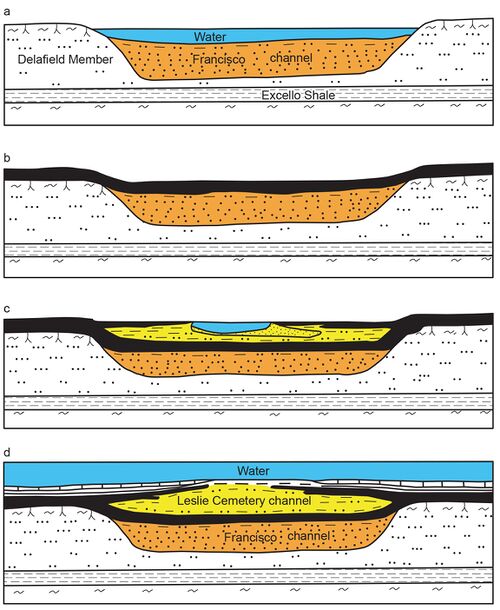 Figure 37 Interpretive diagram showing sequential development of the Leslie Cemetery channel. (a) The Francisco channel is eroded and filled with sediment, largely sand. (b) Springfield peat accumulates in swale left by the abandoned channel. (c) Flowing water reoccupies the channel during the later stages of peat accumulation. Peat encroaches from the margins as the channel migrates laterally. (d) A marine incursion drowns the region and deposits black shale and limestone. Channel filling inverts the topography because of differential compaction.

Primary Source
References
- ↑ Eggert, D.L., 1978, A distributary channel contemporaneous with deposition of the Springfield Coal member (V), Petersburg Formation (Pennsylvanian) in Warrick County, Indiana: Geological Society of America, Abstracts with Programs, v. 10, p. 395.
- ↑ a b c d Eggert, D.L., 1982, A fluvial channel contemporaneous with deposition of the Springfield Coal Member (V), Petersburg Formation, northern Warrick County, Indiana: Indiana Geological Survey, Special Report 28, 20 p.
- ↑ a b Eggert, D.L., 1984, The Leslie Cemetery and Francisco distributary fluvial channels in the Petersburg Formation (Pennsylvanian) of Gibson County, Indiana, U.S.A., in R.A. Rahmani and R.M. Flores, eds., Sedimentology of coal and coal-bearing sequences: International Association of Sedimentologists, Special Publication 7, p. 309–315.
- ↑ Eggert, D.L., 1994, Coal resources of Gibson County, Indiana: Indiana Geological Survey, Special Report 50, 36 p., 1 pl.
- ↑ Eggert, D.L., and S.C. Adams, 1985, Distribution of fluvial channel systems contemporaneous with the Springfield Coal Member (Middle Pennsylvanian) in southwestern Indiana, in A.T. Cross, ed., Economic geology: Coal, oil and gas: Ninth International Congress of Carboniferous Geology and Stratigraphy, Proceedings, v. 4: Carbondale, Southern Illinois University Press, p. 342–348.
- ↑ a b c d e f g Willard, D.A., W.A. DiMichele, D.L. Eggert, J.C. Hower, C.B. Rexroad, and A.C. Scott, 1995, Paleoecology of the Springfield Coal Member (Desmoinesian, Illinois Basin) near the Leslie Cemetery paleochannel, southwestern Indiana: International Journal of Coal Geology, v. 27, p. 59–98.
- ↑ Phillips, T.L., and W.A. DiMichele, 1998, A transect through a clastic-swamp to peat-swamp ecotone in the Springfield Coal, Middle Pennsylvanian age, of Indiana, USA: Palaios, v. 13, p. 113–128.