Galatia Channel:Herrin Coal, Energy Shale, and Walshville Channel
Herrin Coal, Energy Shale, and Walshville Channel
The gray, nonmarine Energy Shale and Walshville channel (Figures 42 and 43) are close analogues of the Dykersburg Shale and Galatia channel. Belts of thick Herrin Coal (up to 13 ft [4.3 m]) flank the channel, and shaly or “split” coal flanks channel margins. Away from the channel, the Herrin has a black shale–limestone roof and uniformly high sulfur content. Near the channel, wedges of the gray Energy Shale intervene between coal and black shale. The sulfur content of the coal is moderate to low (0.5% to 2.5%) where the Energy Shale is thicker than about 20 ft (6 m; Johnson 1972[1]; Allgaier and Hopkins 1975[2]; Treworgy and Bargh 1984[3]; Nelson et al. 1987[4]).
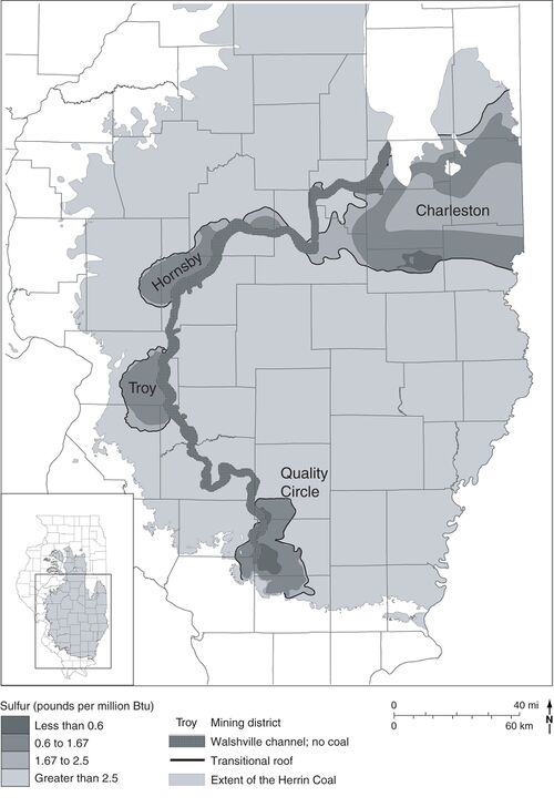 Figure 43 Map showing the Walshville channel and sulfur content of the Herrin Coal. After Treworgy et al. (2000)[5]. The four named areas of low-sulfur coal are all associated with thick Energy Shale adjacent to the channel.


The Energy Shale consists of gray mudstone, siltstone, and sandstone as thick as 120 ft (37 m). It is thickest and coarsest near the channel, becoming thin and lenticular at its outer limits. The sparse fauna comprises brackish-water forms such as Lingula, Dunbarella, Myalina, the brachiopod Leaia tricarinata, and rare cephalopods and eurypterids. Fossil land plants are abundant and well preserved, including stands of upright stumps (mainly lycopsids) rooted at the top of the coal (DiMichele and DeMaris 1987[6]; DiMichele et al. 2007[7]). Locally, the Energy Shale contains siderite concretions similar to those of Mazon Creek, containing fossils of plants and soft-bodied invertebrates (Gastaldo 1977[8]; Baird et al. 1985b[9]). Shared with the Dykersburg are features including tidal rhythmites (Archer and Kvale 1993[10]; DiMichele et al. 2007[7]), a variety of rolls (Edwards et al. 1979[11]; Krausse et al. 1979[12]; Bauer and DeMaris 1982[13]; Nelson 1983[14]), and a major coal disruption that suggests large-scale rafting of peat (Nelson 1983, p. 21–23)[14]. Away from the Walshville channel, the Energy Shale is eroded into pods beneath the black, fissile, marine Anna Shale. The Anna–Energy contact is clearly erosional, having locally more than 15 ft (4.5 m) of relief with bedding of the Energy Shale truncated at a 20° angle. Finally, the Anna and overlying marine Brereton Limestone onlap and pinch out against the tidally deposited, gray siltstone and sandstones that fill the core of the Walshville channel (Bauer and DeMaris 1982[13]; DeMaris et al. 1983[15]; DeMaris 2000[16]). The Turner Mine Shale and St. David Limestone pinch out in similar fashion where the Dykersburg Member is thick.
Although no precursor Walshville channel has been mapped, core drilling in several areas confirms a deeply incised, sandstone-dominated valley fill below the belt of thick Herrin Coal. As with the Galatia, the precursor Walshville channel is considerably wider than the contemporaneous portion (as defined by the absence of Herrin Coal). Moreover, the Walshville channel, like the Galatia, exhibits looping meanders that did not migrate laterally. Authors through the 1980s attributed the Energy Shale, like the Dykersburg, to crevasse splays and related environments in a river-dominated deltaic setting similar to the modern Mississippi (Johnson 1972[1]; Allgaier and Hopkins 1975[2]; Nelson 1983[14]; Palmer et al. 1985[17]; Treworgy and Jacobson 1979[18]; Burk et al. 1987[19]). Archer and Kvale (1993)[10] pointed out flaws in this model, including the absence of natural levees, the absence of unequivocal evidence for crevasse splays, and the presence of a strong tidal signature. Their model calls for a mud-dominated, tropical estuary or tidal delta having a small to moderate tidal range.
Primary Source
References
- ↑ a b Johnson, D.O., 1972, Stratigraphic analysis of the interval between the Herrin (No. 6) Coal and the Piasa Limestone in southwestern Illinois: Urbana, University of Illinois, Ph.D. thesis, 105 p.
- ↑ a b Allgaier, G.J., and M.E. Hopkins, 1975, Reserves of the Herrin (No. 6) Coal in the Fairfield Basin in southeastern Illinois: Illinois State Geological Survey, Circular 489, 31 p., 2 pls.
- ↑ Treworgy, J.D., and M.H. Bargh, 1984, Coal resources of Illinois, Herrin (No. 6) Coal: Illinois State Geological Survey, 1 map sheet, 1:500,000.
- ↑ Nelson, W.J., P.J. DeMaris, and R.A. Bauer, 1987, The Hornsby district of low-sulfur Herrin Coal in central Illinois (Christian, Macoupin, Montgomery, and Sangamon Counties): Illinois State Geological Survey, Circular 540, 40 p., 1 pl.
- ↑ Treworgy, C.G., C.P. Korose, C.A. Chenoweth, and D.L. North, 2000, Availability of the Springfield Coal for mining in Illinois, map summary of Illinois Minerals 118: Illinois State Geological Survey, 1 sheet, 1:500,000.
- ↑ DiMichele, W.A., and P.J. DeMaris, 1987, Structure and dynamics of a Pennsylvanian-age Lepidodendron forest: Colonizers of a disturbed swamp habitat in the Herrin (No. 6) Coal of Illinois: Palaios, v. 2, p. 146–157.
- ↑ a b DiMichele, W.D., H.J. Falcon-Lang, W.J. Nelson, S.D. Elrick, and P.R. Ames, 2007, Ecological gradients within a Pennsylvanian mire forest: Geology, v. 35, no. 5, p. 415–418.
- ↑ Gastaldo, R.A., 1977, A Middle Pennsylvanian nodule flora from Carterville, Illinois, in R.C. Romans, ed., Geobotany: New York, Plenum Press, p. 133–155.
- ↑ Baird, G.C., S.D. Sroka, C.W. Shabica, and T.L. Beard, 1985b, Mazon-Creek-type fossil assemblages in the U.S. Midcontinent Pennsylvanian: Their recurrent character and palaeoenvironmental significance: Philosophical Transactions of the Royal Society, London, v. 311, p. 87–99.
- ↑ a b Archer, A.W., and E.P. Kvale, 1993, Origin of gray shale lithofacies (clastic wedges) in U.S. Midcontinent coal measures (Pennsylvanian): An alternate explanation: Geological Society of America, Special Paper 286, p. 181–192.
- ↑ Edwards, M.J., R.L. Langenheim Jr., W.J. Nelson, and C.T. Ledvina, 1979, Lithologic patterns in the Energy Shale and the origin of “rolls” in the Herrin (No. 6) Coal, Pennsylvanian, in the Orient No. 6 Mine, Jefferson County, Illinois: Journal of Sedimentary Petrology, v. 49, no. 3, p. 1005–1014.
- ↑ Krausse, H.-F., H.H. Damberger, W.J. Nelson, S.R. Hunt, C.T. Ledvina, C.G. Treworgy, and W.A. White, 1979, Roof strata of the Herrin (No. 6) Coal Member in mines of Illinois: Their geology and stability: Illinois State Geological Survey, Illinois Minerals Note 72, 54 p.
- ↑ a b Bauer, R.A., and P.J. DeMaris, 1982, Geologic investigation of roof and floor strata: Longwall demonstration, Old Ben Mine No. 24: Illinois State Geological Survey, Contract/Grant Report 1982-2, 49 p.
- ↑ a b c Nelson, W.J., 1983, Geologic disturbances in Illinois coal seams: Illinois State Geological Survey, Circular 530, 47 p.
- ↑ DeMaris, P.J., R.A. Bauer, R.A. Cahill, and H.H. Damberger, 1983, Geologic investigation of roof and floor strata, longwall demonstration, Old Ben Nine No. 24, prediction of coal balls in the Herrin Coal: Illinois State Geological Survey, Contract/Grant Report 1983-2, 69 p.
- ↑ DeMaris, P.J., 2000, Formation and distribution of coal balls in the Herrin Coal (Pennsylvanian), Franklin County, Illinois Basin, USA: Journal of the Geological Society of London, v. 157, p. 221–228.
- ↑ Palmer, J.E., C.B. Trask, and R.J. Jacobson, 1985, Depositional environments of strata of late Desmoinesian age overlying the Herrin (No. 6) Coal in southwestern Illinois and the occurrence of low-sulfur coal, in A.T. Cross, ed., Economic geology: Coal, oil and gas: Ninth International Congress on Carboniferous Stratigraphy and Geology, Proceedings, v. 4: Carbondale, Southern Illinois University Press, p. 321–340.
- ↑ Treworgy, C.G., and R.J. Jacobson, 1979, Paleoenvironments and distribution of low-sulfur coal in Illinois, in A.T. Cross, ed., Economic geology: Coal, oil and gas: Ninth International Congress on Carboniferous Stratigraphy and Geology, Proceedings, v. 4: Carbondale, Southern Illinois University Press, p. 349–359.
- ↑ Burk, M.K., M.P., Deshowitz, and J.E. Utgaard, 1987, Facies and depositional environments of the Energy Shale Member (Pennsylvanian) and their relationship to low-sulfur coal deposits in southern Illinois: Journal of Sedimentary Petrology, v. 57, no. 6, p. 1060–1067.