Galatia Channel:Delafield Member

Delafield Member (New)
Name and definition
Between the Hanover Limestone and the base of the Springfield Coal is a thick, regionally extensive interval of shale, siltstone, sandstone, and mudstone that typically coarsens upward. The name Delafield Member is hereby proposed in reference to the community of Delafield in Hamilton County, southern Illinois.
Type section
The type section of the Delafield Member is the core from the Energy Plus ME-13 borehole, which was drilled about 1.6 mi (2.5 km) southeast of Delafield (sec. 31, T 4 S, R 6 E, Hamilton County, county no. 25463). The member occupies the depth interval from 1,048.3 to 1,123.2 ft (319.5 to 342.4 m) in the core and is 74.9 ft (22.8 m) thick (Figure 6 and Appendix, part C). The entire core from the Energy Plus borehole is in permanent storage at the Illinois State Geological Survey (ISGS) Samples Library. The core description, a gamma-ray–density log, and other data on the borehole are on file at the ISGS Geologic Records Unit and available via the ISGS website.

Appendix, part C -- Type Section of the Delafield Member (New)
From continuous core of Energy Plus borehole no. ME-13, drilled 2,605 ft (794 m) from south line, 1,274 ft (388 m) from west line, Sec. 31, T4S, R6E, Hamilton County, Illinois. Core described by W. John Nelson, January 4–5, 2007.
| Table A1 Type Section of the Delafield Member (new) | |||
|---|---|---|---|
| Thickness (ft) | Top depth | Bottom depth | Rock description |
| 4.6 | 1,043.7 | 1,048.3 | Springfield Coal Member, bright banded, partly removed by company; depths from company log. |
| 4.7 | 1,048.3 | 1,053.0 | Top of Delafield Member, claystone (underclay), nearly black at top, changing downward to dark gray, olive gray in lower half. Blocky, thoroughly slickensided, lower 3 feet [0.9 m] calcareous, with scattered small limestone nodules. Lower contact gradational. |
| 6.3 | 1,053.0 | 1,059.3 | Sandstone, medium gray, very fine grained, micaceous, lithic arenite. Brecciated at the top with zigzag fractures extending downward and irregular masses of dark gray dolomite(?) at top. Dark gray siltstone laminae become more numerous downward, outlining wavy and ripple lamination. Lower contact gradational. |
| 35.7 | 1,059.3 | 1,095.0 | Sandy siltstone and shale, medium gray, mostly planar laminated, some ripples and horizontal burrows in sand-rich interval, possible tidal rhythmites. Interlaminated light gray sandstone is 10 to 30% of rock, reaching a maximum at 1,068–1,076 ft [325.5 to 328.0 m] and decreasing below that point. Trace fossils Teichichnus and Conostichus identified by J.A. Devera. Lower contact gradational. |
| 22.0 | 1,095.0 | 1,117.0 | Shale, medium-dark gray, silty, becoming darker and finer downward, laminae of very fine sandstone confined to upper part. “Pyrite trails” common, siderite bands and lenses occur in lower 14 feet [4 m]. Lower contact gradational. |
| 6.2 | 1,117.0 | 1,123.2 | Shale, dark gray, contains little or no silt, very fissile; “pyrite trails” and siderite lenses numerous. Lower contact rapidly gradational, base of Delafield Member. |
| 0.4 | 1,123.2 | 1,123.6 | Hanover Limestone Member, calcareous shale, grayish black, contains scattered echinoderm and fossil shell fragments; lenses of dark gray, micritic limestone occur near base; lower contact rapidly gradational. |
| 8.4 | 1,123.6 | 1,132.0 | Excello Shale Member, black, low-density, fissile; phosphatic lenses and pyrite nodules. Concretion of black microgranular dolomite occurs at 1,126.0 to 1,127.7 feet [343.2 to 343.7 m]. Lower contact appears erosive; Houchin Creek Coal is absent. |
| 3.0 | 1,132.0 | 1,135.0 | Sandstone, medium greenish gray, very fine grained, micaceous, lithic arenite. |
Thickness and distribution
Weiner (1961)[1] produced a map showing the thickness of what is essentially the Delafield Member in the Illinois Basin. Wanless et al. (1963[2], figure 13) and Wanless et al. (1970[3], figure 4) published more legible versions. As reproduced here (Figure 7), the map shows that the Delafield Member thins westward from maximum values of more than 98.4 ft (>30 m) in southwestern Indiana and southeastern Illinois. The greatest known thickness is 124.7 ft (38 m) in eastern Wayne County, Illinois. The Delafield thins to less than 16.4 ft (<5 m) in much of western and northern Illinois, although the detailed pattern undoubtedly is more complex than shown in Figure 7.
-
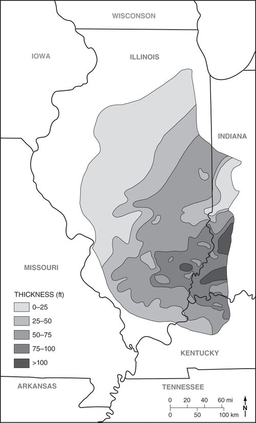 Figure 7 Isopach map of the Delafield Member. After Wanless et al. (1970)[4]. Thicknesses are in feet.

Lithology
The Delafield consistently coarsens upward. Dark gray, sideritic clay-shale that contains abundant nodules and bands of siderite is at the base. This grades upward through silty shale to siltstone and fine-grained sandstone. Shale, siltstone, and sandstone are commonly interlaminated in the upper Delafield. Structures include planar, wavy, ripple, and cross-lamination, along with slumped lamination. Definite neap–spring tidal bundles were displayed in one of the cores examined. At the top, siltstone grades upward to claystone or silty mudstone having paleosol features (Springfield underclay). The upward-coarsening profile is evident on electric and other geophysical logs (Figure 5a, Figure 5b).
-
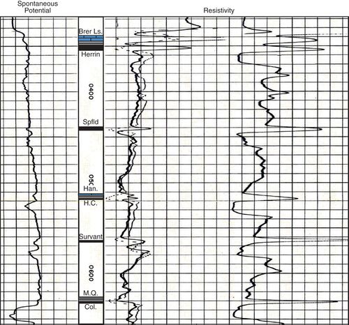 Figure 5a Wireline log illustrating the typical response of key units. (a) Electric log of Carter Oil No. 1 Beers well in sec. 28, T8S, R4E, Williamson County, Illinois (county no. 2107). B, Brereton Limestone; H, Herrin Coal; Sp, Springfield Coal; Han, Hanover Limestone; HC, Houchin Creek Coal; SV, Survant Coal; MQ, Mecca Quarry Shale; C, Colchester Coal. (b) Gamma-ray–resistivity log of Peabody Natural Gas No. 2 Short, in sec. 14, T7S, R7E, Hamilton County (county no. 25375).
 -
 Figure 5b Wireline log illustrating the typical response of key units. (a) Electric log of Carter Oil No. 1 Beers well in sec. 28, T8S, R4E, Williamson County, Illinois (county no. 2107). B, Brereton Limestone; H, Herrin Coal; Sp, Springfield Coal; Han, Hanover Limestone; HC, Houchin Creek Coal; SV, Survant Coal; MQ, Mecca Quarry Shale; C, Colchester Coal. (b) Gamma-ray–resistivity log of Peabody Natural Gas No. 2 Short, in sec. 14, T7S, R7E, Hamilton County (county no. 25375).


Contacts
The base of the Delafield Member is the top of the Hanover Limestone or, where the Hanover is absent, the top of the Excello Shale. This contact is sharp or gradational within an interval a few centimeters thick. The top of the Delafield is the base of the Springfield Coal or the base of the new Galatia Member. The contact to the coal is generally conformable but sharp, whereas the contact to the Galatia Member is erosive. Where the Galatia Member is absent, the underclay of the Springfield Coal is part of the Delafield Member.
Fossils
Fossils are scarce in the Delafield Member, but they record a transition from near-normal marine conditions at the outset of deposition to increasingly brackish water through time. Articulate brachiopods, crinoid fragments, and other marine forms occur at the base. Above this are found rare pectenoid pelecypods, linguloid brachiopods, a single nautiloid cephalopod, and plant fragments. Burrows are present but not common. The type core contains the trace fossils Teichichnus and Conostichus, which have marine affinities.
Interpretation
The Delafield reflects a rapidly prograding shoreline. Deposition apparently took place in a complex of deltas and shoaling bays; normal marine salinity rapidly gave way to brackish water. At the end of Delafield deposition, terrestrial clastics essentially filled the Illinois Basin as marginal marine sedimentation gave way to emergence and soil formation (underclay of Springfield Coal).
Additional Reading
Delafield Member on ILSTRAT
Primary Source
References
- ↑ Weiner, J.L., 1961, Environmental study of stages within the Summum cyclothem of Illinois: Urbana, University of Illinois, M.S. thesis, 31 p.
- ↑ Wanless, H.R., J.B. Tubb Jr., D.E. Gednetz, and J.L. Weiner, 1963, Mapping sedimentary environments of Pennsylvanian cycles: Geological Society of America Bulletin, v. 74, no. 4, p. 437–486.
- ↑ Wanless, H.R., J.R. Baroffio, J.C. Gamble, J.C. Horne, D.R. Orlopp, A. RochaCampos, J.E. Souter, P.C. Trescott, R.S. Vail, and C.R. Wright, 1970, Late Paleozoic deltas in the central and eastern United States, in J.P. Morgan and R.H. Shaver, eds., Deltaic sedimentation, modern and ancient: Society of Economic Paleontologists and Mineralogists, Special Publication 15, p. 215–245, https://doi.org/10.2110/pec.70.11.0215.
- ↑ Wanless, H.R., J.R. Baroffio, J.C. Gamble, J.C. Horne, D.R. Orlopp, A. RochaCampos, J.E. Souter, P.C. Trescott, R.S. Vail, and C.R. Wright, 1970, Late Paleozoic deltas in the central and eastern United States, in J.P. Morgan and R.H. Shaver, eds., Deltaic sedimentation, modern and ancient: Society of Economic Paleontologists and Mineralogists, Special Publication 15, p. 215–245, https://doi.org/10.2110/pec.70.11.0215