Galatia Channel:Plates
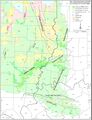
Plate 1 Map of the southeastern part of the Illinois Basin showing the thickness of the Springfield Coal, channels that affect the coal, and major structural features
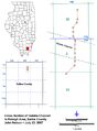
Plate 2 - Map overview Cross section of the Galatia channel near Raleigh in Saline County, Illinois
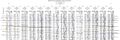
Plate 2 Cross section of the Galatia channel near Raleigh in Saline County, Illinois
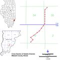
Plate 3 - Map overview Cross section of the Galatia channel in Wabash County, Illinois
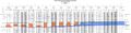
Plate 3 Cross section of the Galatia channel in Wabash County, Illinois
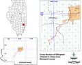
Plate 4 - Map overview Cross section of the Effingham channel at Olney in Richland County, Illinois
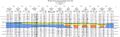
Plate 4 Cross section of the Effingham channel at Olney in Richland County, Illinois
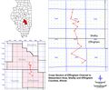
Plate 5 - Map overview Cross section of the Effingham channel near Stewardson in Effingham and Shelby Counties, Illinois
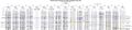
Plate 5 Cross section of the Effingham channel near Stewardson in Effingham and Shelby Counties, Illinois
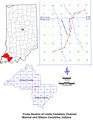
Plate 6 - Map overview Cross section of the Leslie Cemetery channel in Gibson and Warrick Counties, Indiana
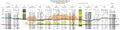
Plate 6 Cross section of the Leslie Cemetery channel in Gibson and Warrick Counties, Indiana


Primary Source
References