Galatia Channel:Danville Coal: Difference between revisions
Alan.Myers (talk | contribs) No edit summary |
Alan.Myers (talk | contribs) No edit summary |
||
| Line 1: | Line 1: | ||
{{Template:Infobox_links/similar}} | {{Template:Infobox_links/similar}} | ||
==Danville Coal== | ==Danville Coal== | ||
The Danville (Figures [[:File:C605-Figure-02.jpg|2]] and [[:File:C605-Figure-40.jpg|40]]) is the next major coal bed above the Baker. It is the youngest widespread, economically important seam in the Illinois Basin. The Danville is thin and rather patchy in western Illinois, reaching 3.3 ft (1 m) thick in small areas. Coal thick enough to mine (generally 3.9 to 5.9 ft [1.2 to 1.8 m] thick) is largely confined to a belt running north-northwest along the east side of the basin from Gibson County, Indiana, into northern Illinois. Coal-thickness patterns (Korose et al. 2002) indicate that much of the thickest coal has been eroded east of the present outcrop. Most Danville Coal has a high sulfur content, but low-sulfur (locally <0.5%) coal occurs in Knox and Sullivan Counties, Indiana, and in the bordering part of eastern Illinois (Harper and Eggert 1995 | The Danville (Figures [[:File:C605-Figure-02.jpg|2]] and [[:File:C605-Figure-40.jpg|40]]) is the next major coal bed above the Baker. It is the youngest widespread, economically important seam in the Illinois Basin. The Danville is thin and rather patchy in western Illinois, reaching 3.3 ft (1 m) thick in small areas. Coal thick enough to mine (generally 3.9 to 5.9 ft [1.2 to 1.8 m] thick) is largely confined to a belt running north-northwest along the east side of the basin from Gibson County, Indiana, into northern Illinois. Coal-thickness patterns (Korose et al. 2002) indicate that much of the thickest coal has been eroded east of the present outcrop. Most Danville Coal has a high sulfur content, but low-sulfur (locally <0.5%) coal occurs in Knox and Sullivan Counties, Indiana, and in the bordering part of eastern Illinois (Harper 1988; Harper and Eggert 1995; Korose et al. 2002). | ||
<div><ul> | <div><ul> | ||
<li style="display: inline-block;">[[File:C605-Figure-02.jpg|500px|{{File:C605-Figure-02.jpg}}|thumb]]</li> | <li style="display: inline-block;">[[File:C605-Figure-02.jpg|500px|{{File:C605-Figure-02.jpg}}|thumb]]</li> | ||
Revision as of 21:36, 16 August 2023
Danville Coal
The Danville (Figures 2 and 40) is the next major coal bed above the Baker. It is the youngest widespread, economically important seam in the Illinois Basin. The Danville is thin and rather patchy in western Illinois, reaching 3.3 ft (1 m) thick in small areas. Coal thick enough to mine (generally 3.9 to 5.9 ft [1.2 to 1.8 m] thick) is largely confined to a belt running north-northwest along the east side of the basin from Gibson County, Indiana, into northern Illinois. Coal-thickness patterns (Korose et al. 2002) indicate that much of the thickest coal has been eroded east of the present outcrop. Most Danville Coal has a high sulfur content, but low-sulfur (locally <0.5%) coal occurs in Knox and Sullivan Counties, Indiana, and in the bordering part of eastern Illinois (Harper 1988; Harper and Eggert 1995; Korose et al. 2002).
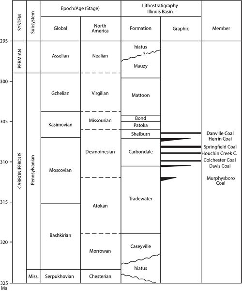 Figure 2 Correlation chart showing the positions of key units within the Pennsylvanian Subsystem. Global and provincial stage boundaries and ages in millions of years (Ma) are after Gradstein et al. (2012)[1].


Overlying the Danville is a complex succession of gray clastic rocks that thickens from less than 3.3 ft (1 m) in parts of western Illinois to as much as 229.7 ft (70 m) in the central Fairfield Basin of southeastern Illinois. Where it is thin, the shale is dark colored and, in places, is black, fissile shale similar to the Excello and Turner Mine Shales. Eastward, the interval changes to gray mudstone, siltstone, and sandstone arranged in multiple upward-coarsening cycles. The coarsest facies occur in Knox County, Indiana, coinciding with the only known area of low-sulfur Danville Coal. Abundant fossil plants, tree stumps in growth position, and tidal rhythmites are much in evidence in underground mines here. Rolls are also common, as are wedge-shaped siltstone splits and a large-scale coal-seam disruption that probably involved peat rafting (Figure 46). However, no channels contemporaneous with the Danville have been encountered.
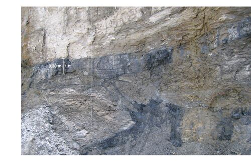 Figure 46 Disruption of the Danville Coal, with the seam “split” by a thick wedge of mudstone. Note the ragged splaying of coal into mudstone, with a thin coal stringer crossing diagonally from the lower to upper “bench.” The site is the box cut at a portal of the Prosperity Mine in Gibson County, Indiana.

Evidently, Knox County lay near the mouth of a large estuary that discharged sediment onto the Danville peat from the east. Rapid burial under freshwater to slightly brackish conditions resulted in low-sulfur coal. Tidal currents agitated the peat near the estuary mouth, whereas deeper in the basin, the peat was quietly buried under fine mud.
Primary Source
References
- ↑ Gradstein, F.M., J.G. Ogg, M.D. Schmitz, and G.M. Ogg, 2012, The geologic time scale 2012, 1st ed.: Amsterdam, Elsevier, 1,144 p.