Survant Coal Member
Lithostratigraphy: Carbondale Formation >>Survant Coal Member
Chronostratigraphy: Paleozoic Erathem >>Pennsylvanian Subsystem >>Desmoinesian Series
Allostratigraphy: Absaroka Sequence
Primary source
Nelson, W.J., P.H. Heckel and J.M. Obrad, 2022, Pennsylvanian Subsystem in Illinois: Illinois State Geological Survey, Bulletin (in press).
Contributing author(s)
W.J. Nelson
Name
Original description
Fuller and Ashley (1902, p. 2) gave the name “Survant coal” to what was previously called Coal IV in southwestern Indiana.
Derivation
The name refers to the ghost town of Survant, which took its name from George T. Survant, the first postmaster (https://en.wikipedia.org/wiki/Survant,_Indiana).
Other names
This unit was called the Lowell Coal Member in northern Illinois (Willman and Payne 1942) and the Shawneetown Coal Member in southern Illinois (Kosanke et al. 1960). In western Kentucky, the names Well, Split, and No. 8 coal bed have been used. The name “Well coal” refers to the coal being encountered in water wells (Greb et al. 1992). Having confirmed that all these units are the same, Jacobson et al. (1985) selected “Survant Coal Member” based on priority.
History/background
None.
Type section
Type location
The type section of the Survant Coal is in a railroad cut and north bank of the Patoka River at the Survant townsite (SW¼ NE¼ sec. 2, T 2 S, R 7 W, Pike County, Indiana).
Type author(s)
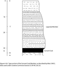
Wier (1961, locality 4). Because this section was never published, it is reproduced here graphically (Figure 4-30) and verbally (below):
TOP
| Feet | Meters | Lithology |
| 6.0 | 1.8 | Shale, light gray, sandy |
| 18.0 | 5.5 | Sandstone, light brown, fine grained, thin to thick bedded, calcareous near top, carbonaceous debris and mica coat bedding planes; unit partly covered |
| 6.0 | 1.8 | Sandstone, brown, fine to medium grained, thick bedded to massive |
| 2.5 | 0.76 | Survant Coal Member, bright banded |
| 1.0 | 0.3 | Underclay, gray |
| 1.0 | 0.3 | Shale, medium gray, base concealed at river |
Total section 34.5 ft (10.5 m).
Type status
Unknown. The core that serves as the principal reference section (1) is closely adjacent.
Reference section(1)
Reference location
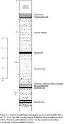
The principal reference section is core from the Indiana Geological Survey’s SDH-306, drilled immediately north of the Survant type section in sec. 2, T 2 S, R 7 W, Pike County, Indiana (Figure 4-7). This core exemplifies the Survant Member where its constituent Wheeler and Bevier Coal Beds cannot be distinguished.
Reference author(s)
Hasenmueller and Ault (1991) published the core description and gamma-ray and electric logs from SDH-306.
Reference status
Logs from SDH-306 are on file at the Indiana Geological Survey and can be downloaded from the Indiana Geological Survey website (well ID number 115871). Core is archived at the Indiana Geological Survey core facility in Bloomington, Indiana.
Reference section(2)
Reference location
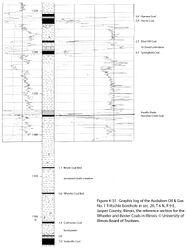
Core from the Audubon Oil & Gas #A-1 Fritschle test hole in sec. 20, T 6 N, R 9 E, Jasper County (ISGS county no. 25354) is designated as a reference section for the Survant Coal Member (Figure 4-31). The Survant Member comprises the Wheeler Coal Bed, 0.6 ft (17 cm) thick; an unnamed clastic interval, 30.4 ft (9.27 m) thick; and the Bevier Coal Bed, 1.1 ft (34 cm) thick, and it spans the depth interval from 1,439.2 to 1,471.2 ft (438.7 to 448.2 m).
Reference author(s)
This report.
Reference status
Logs of the Fritschle borehole are on file at the Geological Records Unit of the ISGS and can be downloaded from the ISGS website. Core is stored at the Geological Samples Library of the ISGS in Champaign under storage number C-15260.
Reference section(3)
Reference location
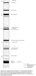
The ISGS #1 CNX Railroad core from Clark County (Figure 4-32) illustrates that the Wheeler and Bevier Coal Beds nearly merged into the Survant Coal Member. The Survant is 3.4 ft (104 cm) thick in the depth interval from 740.6 to 744.0 ft (225.7 to 226.8 m) and has a claystone layer 0.25 ft (7.6 cm) thick near the middle, representing the unnamed clastic interval between the Wheeler and Bevier beds.
Reference author(s)
This report.
Reference status
Logs of the CNX Railroad borehole are on file at the Geological Records Unit of the ISGS and can be downloaded from the ISGS website. Core is archived at the ISGS Geological Samples Library in Champaign, but this core presently lacks a call number.
Reference section(4)
Reference location
Indiana Geological Survey test hole SDH-366 has been proposed as a reference section illustrating the Survant where the two “benches” of coal are separated by a thick clastic interval. The hole was drilled 800 feet from north line, 400 feet from west line of sec. 27, T 5 S, R 10 W in Vanderburgh County, Indiana. The Survant Member resides in the depth interval from 480.5 to 493.3 feet and comprises upper coal 2.4 feet (73 cm) thick, shale 9.5 feet (2.9 m) thick, and lower coal 0.9 foot (27 cm) thick. Records include continuous core described by Nancy R. Hasenmueller together with resistivity, gamma-ray, neutron, and density logs.
Reference author(s)
Mastalerz et al. (2019).
Reference status
Logs of SDH-366 are on file at the Indiana Geological Survey and can be accessed online via the Petroleum Database Management System under well ID no. 150359. Core is archived at the IGS under call number 780.
Reference section(5)
Reference location
- Indiana Geological Survey test hole SDH-325 has been proposed to exemplify the Survant Member where the coal “benches” are separated by a relative thin clastic layer. The hole was drilled 1450 feet from south line, 10120 feet from west line of sec. 22, T 8 N, R 7 W in Greene County, Indiana. The Survant Member lies in the approximate depth interval from 85 to 91 feet and is approximately 6 feet (1.8 m) thick. Records include a driller’s log and an electric log; no cores were taken.
Reference author(s)
Mastalerz et al. (2019).
Reference status
Logs of SDH-325 are on file at the Indiana Geological Survey and can be accessed online via the Petroleum Database Management System under well ID #115871.
Stratigraphic relationships
Geologists have long known that the Survant Coal consists of two distinct coal beds that merge in some areas to form a single seam. Likewise, the Wheeler (older) and Bevier Coal Beds of the Midcontinent locally unite. The lower and upper “benches” of the Survant Coal in the Illinois Basin are hereby named the Wheeler and Bevier Coals, respectively. The Wheeler and Bevier are regarded as members when considered separately and as beds where they are components of the Survant Coal Member. The situation is analogous to the Davis and Dekoven Coals merging to form the Seelyville Coal Member.
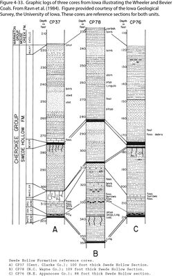
In Iowa and Missouri, the Wheeler and Bevier Coals are separated by a clastic interval that varies in thickness from a featheredge to at least 25 ft (7.6 m) thick. Where the two coal beds are widely separated, each clearly occupies a separate cyclothem composed of rooted underclay, coal, and marine shale or limestone (Howe and Koenig 1961; Wanless 1964; Gentile 1967, 1968; Ravn et al. 1984; Gentile and Thompson 2004; Pope 2012). An example of the Wheeler and Bevier merging in Iowa is illustrated (Figure 4-33). The same relationship prevails in Indiana, where the Survant has been mined extensively. In nearly all the mines, a rock “parting” ranging from less than an inch (~3 cm) to nearly 30 ft (9 m) in thickness occurs in the middle to mid-lower part of the bed. Naturally, most of the mining took place where the “parting” was thinnest and the total seam thickness greatest, generally from 4 ft to more than 6 ft (1.2 to >1.8 m; Wier 1973; Harper 1985, 1988a, 1988b; Eggert 1994; Harper and Eggert 1995; Mastalerz et al. 2019).
Because of a lack of mining in the Survant in Illinois and Kentucky, little has been published about the unit in these states. Harrison (1951) alluded to two coal seams, 8 to 16 ft (2.4 to 4.8 m) apart, lying in the interval between No. 2 (Colchester) and No. 4 (Houchin Creek) coals in White County, Illinois. Kosanke et al. (1960) referred to the Shawneetown Coal Member as the upper of two coal layers, commonly called No. 2A coal in southern Illinois. Jacobson (1987, p. 12) described the Survant as a “split coal” that “has a persistent shale parting that generally is no more than a few feet [~1 m] thick, but the parting increases to as much as 30 feet [9 m] in northwestern Vigo County, Indiana, and in southeastern Illinois.” Jacobson (1987) illustrated this relationship in several cross sections. The Survant has been called the “Split coal” in western Kentucky because of the widespread occurrence of a shale or claystone layer within the seam (David A. Williams, Kentucky Geological Survey, written communication, 2017).
Because of a lack of mining in the Survant in Illinois and Kentucky, little has been published about the unit in these states. Harrison (1951) alluded to two coal seams, 8 to 16 ft (2.4 to 4.8 m) apart, lying in the interval between No. 2 (Colchester) and No. 4 (Houchin Creek) coals in White County, Illinois. Kosanke et al. (1960) referred to the Shawneetown Coal Member as the upper of two coal layers, commonly called No. 2A coal in southern Illinois. Jacobson (1987, p. 12) described the Survant as a “split coal” that “has a persistent shale parting that generally is no more than a few feet [~1 m] thick, but the parting increases to as much as 30 feet [9 m] in northwestern Vigo County, Indiana, and in southeastern Illinois.” Jacobson (1987) illustrated this relationship in several cross sections. The Survant has been called the “Split coal” in western Kentucky because of the widespread occurrence of a shale or claystone layer within the seam (David A. Williams, Kentucky Geological Survey, written communication, 2017).
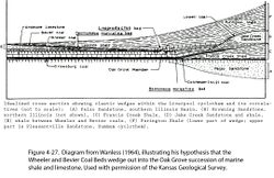
Wanless (1964, p. 600–601) and Wright (1965, p. 80) proposed that marine units overlying the Wheeler and Bevier Coals merge into the limestone–shale succession of the Oak Grove Member (Figure 4-27). This scenario requires that the two coal seams and their respective underclay (paleosols) transition laterally into marine shale, with continuous marine sedimentation on the shelf, while coal and paleosol formed in the deep basin. The Wanless–Wright model can be disproved via correlation of borehole records from basin to shelf in Illinois. These records include many cores not available during the 1960s. Traced westward, the Wheeler and Bevier Coals rise in the section as they pinch out, and their underclays (paleosols) merge with that of the Houchin Creek Coal. Thus (as one would expect), the Western Shelf remained high and well drained, precluding the formation and preservation of Wheeler and Bevier peat.
Extent and thickness
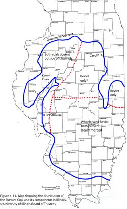
The Survant Coal is best developed in the Fairfield Basin and on the eastern part of the Western Shelf south of the latitude of Springfield and Decatur (Figure 4-34). The lower (Wheeler) and upper (Bevier) beds are separate in most of this area, but locally the two merge into a single seam of coal. North of Springfield and Decatur, the Survant occurs as a single seam that ranges from a streak to about 3 ft (0.9 m) thick and lies close to midway between the Colchester and Houchin Creek Coals. Whether this is the Wheeler, Bevier, or the two merged is uncertain, but widely scattered core records do not indicate a clastic layer within the coal. The Survant crops out in LaSalle County, where Willman and Payne (1942) named it the Lowell coal. These authors described a single seam ranging up to 3 ft (0.9 m) thick, grading to carbonaceous shale where thin. Overlying the coal is shale that is gray to mottled red and green, with nodules and thin interbeds of limestone containing a marine fauna that includes articulate brachiopods and horn corals. The Survant Coal (both beds) is largely absent west of the Du Quoin Monocline and in west-central Illinois. The Survant is locally thick enough to mine in western Kentucky and currently is being mined underground in Armstrong Energy’s Survant Mine near Central City in Muhlenberg County, Kentucky.
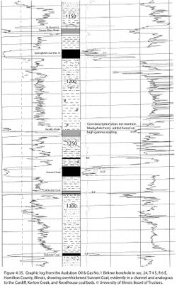
Isopach maps in Mastalerz et al. (2019) depict thicknesses of the upper and lower Survant coal benches and of the clastic interval that separates them in Indiana. These authors also mapped thicknesses of the intervals between the Survant and the Excello Shale, above and Mecca Quarry Shale, below. At a number of sites scattered around the Illinois Basin, abnormally thick Survant Coal fills abandoned channels eroded into the Purington Shale. In the three best-documented examples, the overthickened coal was named as a distinct unit: Cardiff Coal Member, Kerton Creek Coal Member, and Roodhouse Coal Member. Additional examples have turned up in boreholes. An example from a continuous core in Hamilton County (Figure 4-35) shows coal 8.5 ft (2.6 m) thick. Thick coal such as this tends to lie below the horizon of the Survant in nearby wells. In this report, the Cardiff, Kerton Creek, and Roodhouse are considered the Survant Coal Member and the older, local names are dropped from formal usage.
Lithology
Like most coal in the Illinois Basin, the Survant is of high-volatile bituminous rank and is generally bright banded with alternating laminae of bright (vitrain) and subordinate dull coal (durain, clarain, and fusain). In western Indiana, where the Survant was mined underground, it had an average sulfur content of 1.6%, roughly half that of other coal seams mined in the district (Harper 1985, 1988b). Additional tables of analytical data are in Mastalerz et al. (2019). In addition to the main clastic wedge that separates the Wheeler and Bevier benches, the Survant locally contains additional layers and bodies of shaly coal or carbonaceous shale. Additional obstacles to mining are features called “rolls,” “faults,” and “horsebacks,” which are seldom adequately defined in geologic terms (Harper 1988a). Possible explanations include clastic dikes and small channels that were active during or shortly after peat formation.
The roof of the Survant Coal may be medium to dark gray shale, siltstone, or, less commonly, sandstone. No fully marine zone has been identified above the Wheeler Coal in Illinois, but pelecypods and inarticulate brachiopods occur in a few cores and outcrops in dark shale directly overlying the coal. Cores from Muhlenberg County, Kentucky, show dark gray to black shale containing marine invertebrates overlying the Survant Coal (David A. Williams, Kentucky Geological Survey, written communication, 2017).
Where the interval between Wheeler and Bevier is less than about 1 ft (0.3 m), it generally consists of claystone or weakly fissile shale that contains root traces and other plant remains. Where this interval is thicker, it is dominantly an upward-coarsening sequence, topped by a well-developed paleosol (underclay) beneath the Bevier Coal.
Core(s)
Photograph(s)
Contacts
Both contacts of both coal beds are typically sharp.
Well log characteristics
Typical for coal.
Fossils
Guennel (1952) analyzed fossil spores of Desmoinesian coal beds of Indiana, including samples of the Survant Coal. Writing before the relationships of these beds had been worked out, Peppers (1970) compared spore floras of the Lowell, Shawneetown, Cardiff, and Coal IV (Survant) of Indiana. He reported that all four were closely similar to one another and distinct from the older Colchester and younger Houchin Creek Coal.
Age and correlation
No direct correlative has been identified outside the Illinois and Midcontinent Basins.
Environments of deposition
Like the older Davis and Dekoven Coals, both Wheeler and Bevier represent extensive coastal peat deposits that developed during separate eustatic cycles of sedimentation. Sea-level fluctuations were of relatively low amplitude. One hypothesis is that the Wheeler peat accumulated on an uneven surface that included abandoned river channels. Upon transgression, the entire peat deposit was submerged, but clastic sediment accumulated only in the depressions. As the sea level dropped, the climate changed back to ever-wet and peat accumulation (Bevier) resumed on a nearly level surface. An alternate model is that peat accumulation (perhaps in raised bogs) was continuous from Wheeler through Bevier time in areas of slow subsidence, whereas the peat was drowned and covered with a wedge of clastic sediment in more rapidly sinking basinal areas (David A. Williams, Kentucky Geological Survey, written communication, 2017).
Economic importance
The Survant Coal was formerly mined extensively in west-central Indiana (Harper 1988a, 1988b), and resources of 1.30 billion tons (1.18 billion metric tons) are estimated to remain (Mastalerz et al. 2009). Resources of 116 million tons (105 million metric tons) have been estimated in western Kentucky. Resources of Survant Coal in Illinois have not been calculated but are almost negligible. This seam was mined underground a century ago at Litchfield, and a few local mines have operated in southern Illinois.
Remarks
References
- Eggert, D.L., 1994, Coal resources of Gibson County, Indiana: Indiana Geological Survey, Special Report 50, 36 p. and 1 pl.
- Fuller, M.L. and G.H. Ashley, 1902, Ditney Folio, Indiana: U.S. Geological Survey, Geologic Atlas of the United States, Folio 84, 8 p., 7 pls., 1:125,000.
- Gentile, R.J., 1967, Mineral commodities of Macon and Randolph Counties: Missouri Geological Survey and Water Resources, Report of Investigations 40, 106 p.
- Gentile, R.J., 1968, Influence of structural movement on sedimentation during the Pennsylvanian Period in western Missouri: University of Missouri Studies, v. 45: Columbia, University of Missouri Press, 84 p., 8 pls.
- Gentile, R.J., and T.L. Thompson, 2004, Paleozoic succession in Missouri, Part 5, Pennsylvanian Subsystem, Volume A, Morrowan strata through Cherokee Group: Missouri Geological Survey, Report of Investigations 70, 241 p. and correlation chart.
- Greb, S.F., D.A. Williams, and A.D. Williamson, 1992, Geology and stratigraphy of the western Kentucky coal field: Kentucky Geological Survey, Series 11, Bulletin 2, 77 p., 1 pl.
- Guennel, G.K., 1952, Fossil spores of the Alleghenian coals in Indiana: Indiana Geological Survey, Bulletin 13, 101 p.
- Harper, D., 1985, Coal mining in Vigo County, Indiana: Indiana Geological Survey, Special Report 34, 67 p.
- Harper, D., 1988a, Underground mines in the Survant Coal Member (Pennsylvanian) of Indiana; Indiana Geological Survey, Special Report 41, 19 p.
- Harper, D., 1988b, Coal mining in Sullivan County, Indiana: Indiana Geological Survey, Special Report 43, 48 p.
- Harper, D., and D.L. Eggert, 1995, Coal mining in Knox County, Indiana: Indiana Geological Survey, Special Report 54, 23 p.
- Harrison, J.A., 1951, Subsurface geology and coal resources of the Pennsylvanian System in White County, Illinois: Illinois State Geological Survey, Report of Investigations 153, 40 p., 3 pls.
- Hasenmueller, W.A., and C.H. Ault, 1991, Reference core and correlation of key beds in the Petersburg and Linton Formations (Pennsylvanian) in Indiana: Indiana Geological Survey, Occasional Paper No. 57, 8 p.
- Howe, W.B., and J.W. Koenig, 1961, The stratigraphic succession in Missouri: Missouri Geological Survey and Water Resources, v. 40, 2nd Series, 183 p. and chart.
- Jacobson, R.J., 1987, Stratigraphic correlations of the Seelyville, Dekoven, and Davis Coals of Illinois, Indiana, and western Kentucky: Illinois State Geological Survey, Circular 539, 27 p. and 2 pls.
- Jacobson, R.J., C.B. Trask, C.H. Ault, D.D. Carr, H.H. Gray, W.A. Hasenmueller, D. Williams, and A.D. Williamson, 1985, Unifying nomenclature of the Pennsylvanian System in the Illinois Basin: Transactions of the Illinois Academy of Science, v. 78, no. 1–2, p. 1–11.
- Kosanke, R.M., J.A. Simon, H.R. Wanless, and H.B. Willman, 1960, Classification of the Pennsylvanian strata of Illinois: Illinois State Geological Survey, Report of Investigations 214, 84 p. and 1 pl.
- Mastalerz, M., P.R. Ames, and A. Drobniak, 2019, The Survant Coal Member of the Linton Formation (Pennsylvanian) in Indiana: geometry, resources, and properties: Indiana Geological Survey, Indiana Journal of Earth Sciences, v. 1, DOI 10.14.14434/ijes.v1i0.26862.
- Mastalerz, M., A. Drobniak, J.A. Rupp, and N.R. Shaffer, 2009, Characterization of Indiana’s coal resource: availability of the reserves, physical and chemical properties of the coal, and present and potential uses: Indiana Geological Survey, Special Report 66, 214 p., CD-ROM.
- Peppers, R.A., 1970, Correlation and palynology of coals in the Carbondale and Spoon Formations (Pennsylvanian) of the northeastern part of the Illinois Basin: Illinois State Geological Survey, Bulletin 93, 173 p.
- Pope, J.P., 2012, Description of Pennsylvanian units, revision of stratigraphic nomenclature, and reclassification of the Morrowan, Atokan, Desmoinesian, Missourian, and Virgilian stages in Iowa: Iowa Geological and Water Survey, Special Report Series No. 5, 140 p.
- Ravn, R.L., J.W. Swade, M.R. Howes, J.L. Gregory, R.R. Anderson, and P.E. Van Dorpe, 1984, Stratigraphy of the Cherokee Group and revision of Pennsylvanian stratigraphic nomenclature in Iowa: Iowa Geological Survey, Technical Information Series No. 12, 76 p.
- Wanless, H.R., 1964, Local and regional factors in Pennsylvanian cyclic sedimentation, in D.F. Merriam, ed., Symposium on cyclic sedimentation: Kansas Geological Survey, Bulletin 169, v. 2, p. 593–605.
- Wier, C.E. 1961, Stratigraphy of the Carbondale and McLeansboro Groups in southwestern Indiana: Indiana Geological Survey, unpublished bulletin, 147 p. and unnumbered appendix, http://hdl.handle.net/2022/3612 (accessed October 5, 2020).
- Wier, C.E., 1973, Coal resources of Indiana: Indiana Geological Survey, Bulletin 42-I, 40 p.
- Willman, H.B., and J.N. Payne, 1942, Geology and mineral resources of the Marseilles, Ottawa, and Streator Quadrangles: Illinois State Geological Survey, Bulletin 66, 388 p., 29 pls.
- Wright, C.R., 1965, Environmental mapping of the beds of the Liverpool cyclothem in the Illinois Basin and equivalent strata of the northern mid-continent region: Urbana, University of Illinois, Ph.D. thesis, 100 p.
ISGS Codes
| Stratigraphic Code | Geo Unit Designation |
|---|---|
