Seelyville Coal Member
Lithostratigraphy: Carbondale Formation >>Seelyville Coal Member
Chronostratigraphy: Paleozoic Erathem >>Pennsylvanian Subsystem >>Desmoinesian Series
Allostratigraphy: Absaroka Sequence
Primary source
Nelson, W.J., P.H. Heckel and J.M. Obrad, 2022, Pennsylvanian Subsystem in Illinois: Illinois State Geological Survey, Bulletin (in press).
Contributing author(s)
W.J. Nelson
Name
Original description
Ashley (1909, p. 31 and chart opposite, p. 97) casually used the name “Seelyville coal” for the bed mined at Seelyville, Indiana.
Derivation
The coal was named for the town of Seelyville, about 9 mi (16 km) east of Terre Haute in Vigo County, Indiana. Jonas Seely laid out the town around the McKeen coal shaft, which operated from 1864 to 1879. This was the first of nearly a dozen underground mines that fostered the town’s economy. Formally incorporated in 1907, Seelyville was home to 1,029 people in 2010.
Other names
The Seelyville was long Coal III in Indiana, where coal beds were given Roman numerals in ascending order.
History/background
This seam was generally known as Coal III until Shaver et al. (1970) formalized it as the Seelyville Coal Member (of the Staunton Formation). Previously, Kosanke et al. (1960, p. 33) proposed the Seelyville Coal Member (of the Spoon Formation) in eastern Illinois, but the unit received little notice in ISGS publications until the 1980s.
Type section
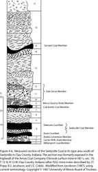
No type section was ever designated. Mines in and around Seelyville are abandoned and inaccessible. Jacobson (1987) published a section from the Chinook Mine in the type area (Figure 4-6), but these pits have been backfilled and exposures no longer exist.
Reference section(1)
Reference location
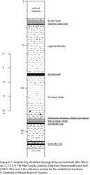
Core from Indiana Geological Survey drill hole SDH-306 has been designated as the principal reference section for the Seelyville Coal Member (Figure 4-7). This hole (IGS ID #115871) was drilled in sec. 2, T 2 S, R 7 W in Pike County, Indiana. The Seelyville Coal is 4.85 ft (148 cm) thick and resides in the depth interval from 161.4 to 166.25 ft (49.2 to 50.7 m).
Reference author(s)
Hasenmueller and Ault (1991).
Reference status
Logs of SDH-306 were published by Hasenmueller and Ault and are on file at the Indiana Geological Survey and are accessible via the Indiana Geological Survey website. Core is archived in the Indiana Geological Survey core storage facility in Bloomington, Indiana, under call number 609.
Reference section(2)
Reference location
The log of hole no. 1 at the Snow Hill Coal Corp.’s Talleydale Mine is hereby offered as a second reference section for the Seelyville Coal Member (Figure 4-8). This hole was drilled about 10 mi (16 km) west-northwest of Seelyville in sec. 20, T 13 N, R 9 W, Vigo County. The hole was cored continuously from the bedrock surface, above the Danville Coal, to a total depth of 586 ft (179 m), nearly 200 ft (61 m) below the Seelyville Coal. George W. Wilson of the ISGS described the core. The Seelyville Coal is 6 ft 7 in. (201 cm) thick in this core and resides at the depth interval of 380 ft 3 in. to 386 ft 1 in. (115.9 to 117.7 m). A band of “bony coal and clay” 2 in. (5 cm) thick occurs 28 in. (71 cm) above the base of the seam.
Reference author(s)
Present report.
Reference status
The core description is in the ISGS Geological Records Unit. Unfortunately, the actual cores are no longer extant.
|
Stratigraphic relationships
Jacobson (1987) demonstrated that the Seelyville Coal in its type area represents the merger of the Davis and Dekoven Coal Members of southern Illinois and western Kentucky. Strong evidence now exists that a third seam, the Abingdon Coal Member, also merges into the Seelyville and that the Seelyville comprises coal from three separate cyclothems that can be correlated into the Midcontinent Basin.
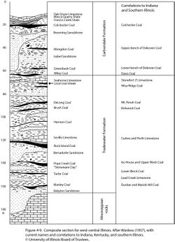
The Abingdon (youngest), Greenbush, and Wiley cyclothems have long been known in western Illinois (Wanless 1931, 1957; Weller et al. 1942). Each comprises underclay, thin coal, local marine limestone or shale, and overlying clastic strata (Figure 4-9). Physical correlations and palynology indicate that the Greenbush and Wiley Coals correlate to the Dekoven and Davis Coals, respectively, in southern Illinois (Kosanke 1950; Peppers 1970, 1996). Heretofore, the Abingdon Coal has not been identified in the eastern part of the Illinois Basin.
However, the Dekoven Coal itself consists of two separate, merged coal layers (Figure 4-10). Smith (1957) first described “splitting” of the Dekoven in southeastern Illinois; this was later confirmed by Jacobson (1987, 1993) and Korose et al. (2002). The “split” appears in northern Gallatin and northwestern Saline Counties and thickens from a feather-edge to 55 ft (17 m) before thinning again farther north (Jacobson 1993). The clastic wedge between the upper and lower Dekoven coarsens upward in some areas, but elsewhere it is composed largely of sandstone (Isabel Sandstone Member) that has an erosive base. Core drilling reveals rooting at the base of the upper Dekoven bench and thin and weakly developed underclay (paleosol). These relationships, combined with the regional extent of the split, indicate distinct episodes of peat formation that “merged” toward the southeast, rather than simple, local “splitting” caused by an autocyclic process such as stream avulsion. Logically, the upper bench of the Dekoven is the Abingdon Coal. The lower bench of the Dekoven is here named the Greenbush Coal.
The merger of two or more named members to form another named member creates a nomenclatural problem. Jacobson (1987) proposed an arbitrary vertical cutoff where the clastic interval between Davis and Dekoven is thinner than 20 ft (6 m). Applying this definition, “Seelyville Member” is used where the clastic wedge is thinner than 20 ft, whereas “Davis” and “Dekoven” are used where the clastics exceed 20 ft. An alternate proposal, endorsed here (Figure 4-10), is to rank the Davis, Dekoven, and Abingdon Coals as members where they are apart and as beds within the Seelyville Coal Member where they are close together. The clastic wedges between the coal beds also could be named, although no names are proposed here. The choice of where to use the name “Seelyville” is indeed arbitrary, but a separation of 20 ft seems excessive. I prefer to restrict “Seelyville” to areas where the coal beds are close enough together to be mined in a single operation and are difficult to distinguish on geophysical logs. This entails a maximum clastic division of about 1 ft (30 cm).
The same phenomenon of merging coals is repeated higher in the Carbondale, where the Wheeler and Bevier Coals join to form the Survant Coal. In addition, the Providence and West Franklin Limestone (Shelburn Formation) and the Livingston Limestone (Bond Formation) represent the merger of smaller units named separately as members elsewhere. The same principle of rank change from member to bed is used in these cases.
Extent and thickness
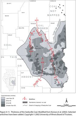
In Indiana, the Seelyville is thickest in its type area of northern Vigo and southern Parke and Vermillion Counties. Average thicknesses are in the range of 5 ft (1.5 m), with some tracts more than 6.6 ft (2.0 m) and an exceptional thickness of 11 ft (3.3 m). Cady (1952) extended the Indiana III (Seelyville) into eastern Illinois and estimated resource tonnage. Clegg (1965) mapped the coal in parts of Clark and Edgar Counties. Treworgy (1981) mapped the unit through a large area of east-central Illinois; Treworgy and Bargh (1984) and Korose et al. (2002) modified the 1981 map slightly. Pods of thick coal are highly irregular and show no relation to structure (Figure 4-11). Other geologic factors that may influence thickness of the Seelyville Coal and its internal clastic wedges have not been assessed.
Cady (1952, p. 77–78) classified about 264 million tons of “Wiley Coal” resources in the Litchfield area, southeast Macoupin and southwest Montgomery Counties, Illinois. Treworgy and Bargh (1984) showed the area of “Wiley” resources on a map. My inspection of drilling records indicates that Cady misidentified the Survant as “No. 2 coal” [Colchester], and his Wiley is really the Seelyville, combined Davis and Dekoven. The coal is roughly 28 to 42 in. (71 to 107 cm) thick and contains a medial shale or claystone layer.
Elsewhere in Illinois, the Seelyville Coal has not been mapped but is widely present. Many areas in the Fairfield Basin are outside the region mapped by Treworgy, where the Davis, Dekoven, Abingdon, or combined Seelyville Coal is thicker than 3 ft (~1 m). On the Western Shelf, the coal layers tend to be much thinner, and in many places, they are difficult to identify.
Lithology
The Seelyville is bright-banded coal that contains one or more layers of claystone or shale corresponding to the clastic interval between Davis and Dekoven. In Indiana, two pyritic claystone layers are commonly present, one in the lower third and the other in the upper third of the seam. Southward from Vigo County, the coal becomes thinner, although pods of thick coal persist. From Sullivan County southward, as many as four “rock partings” seem to be present; they thin southward as the Seelyville “splits apart” (Hutchison 1960; Powell 1968; Harper 1985, 1988b; Shaver et al. 1986; Eggert 1994; Harper and Eggert 1995). Aside from clastic layers, the Seelyville has the highest mean ash (14.5%) and sulfur (5.0%) values of any widely mined seam in Indiana, and its heating value is the lowest. Ash and sulfur values vary widely, but a sulfur content below 3% is rare (Mastalerz and Harper 1998). Further negative issues for underground mining include a weak, moisture-sensitive shale roof and a thick, plastic claystone floor that is prone to squeezing (Harper 1985).
Core(s)
Photograph(s)
Contacts
Both contacts of the coal are normally sharp.
Well log characteristics
Typical for coal, but the Seelyville commonly shows one or more clastic layers on large-scale logs.
Fossils
Peppers (1970) listed and discussed fossil spores of the Seelyville. Working when the physical equivalence of Seelyville and Dekoven was yet to be established, Peppers noted floral differences between the two. Peppers (1996) further addressed the regional and global correlation of the Seelyville by using palynology.
Age and correlation

The Seelyville is near the middle of the Desmoinesian Series. Components of the Seelyville can be identified in the Midcontinent with strong confidence based on physical correlations and conodont biostratigraphy. Beginning at the base of the chart (Figure 4-12), the acme zone of the conodont Gondolella pulchra occurs below the Seelyville in the Carrier Mills Shale. The same zone occurs in marine shale associated with the Elliott Ford Limestone in Iowa and black shale between the Tebo Coal and Tiawah Limestone in Missouri and Kansas (Pope 2012; Heckel 2013). Moving upward, the Mineral Coal of Iowa, Missouri, and Kansas is the most likely correlative of the Davis. At several localities in Missouri, including the principal reference section, the Mineral Coal is overlain by black, fissile, phosphatic shale that contains large carbonate concretions. This shale probably matches the Will Scarlet Shale overlying the Davis Coal in the Illinois Basin. Conodonts from the shale above the Mineral Coal have been identified (Heckel 2013), but conodonts of the Will Scarlett Shale have not been investigated.
Correlation of the Colchester Coal of Illinois with the Whitebreast Coal of Iowa and the Croweburg Coal of Missouri, Kansas, and Oklahoma has been accepted for decades. Conodonts from overlying black, phosphatic shale (Mecca Quarry in Illinois, Oakley Member in the Midcontinent) strengthen this correlation. This leaves the thin, lenticular Robinson Branch Coal and thicker, more widespread Fleming Coal of Missouri as probable equivalents of the Greenbush and Abingdon Coals, respectively.
Environments of deposition
Overall, the Seelyville and its component beds fit the general model for peat accumulation during eustatic lowstand in coastal wetlands. The merger of two or more coal deposits from separate cyclothems is a subject that has scarcely been addressed in the literature. Wanless (1964) presented several examples of “merging” coal seams and recognized that these often entail the junction of separate cyclothems. The only suggested mechanism is that greater tectonic subsidence in one area of the basin allowed the introduction of a “clastic wedge.” As illustrated, several of Wanless’s clastic wedges include marine limestone at the base and rooted underclay at the top.
It is easier to visualize the process in areas where the cyclothems are apart than where they are together. In the latter case, we must infer that following accumulation of the lower peat deposit, neither erosion nor deposition took place until the upper peat layer formed. David A. Williams (Kentucky Geological Survey, written communication, 2017) suggested that a raised peat bog developed on the stable shelf and peat formed continuously, whereas in the more rapidly subsiding basin, the peat was drowned and overtopped by clastic sediments. Petrographic investigation of split versus merged seams might help resolve their origin.
Economic importance
The Seelyville Coal is a major economic seam in Indiana, where 6.6 billion tons (5.98 billion metric tons) of resources remain out of 14.61 billion tons (13.25 billion metric tons) originally in the ground (Mastalerz et al. 2009). Mining is concentrated north and east of Terre Haute, with scattered smaller operations along the outcrop belt to the south. One mine near Terre Haute worked a short distance into Illinois from a shaft in Indiana. Treworgy (1981) estimated Seelyville resources in east-central Illinois at about 8 billion tons (7.3 billion metric tons). Keystone (2010) boosted this estimate to 9.7 billion tons (8.8 billion metric tons). In southern Illinois and western Kentucky, the Seelyville splits into the Davis and Dekoven Coals, which together account for greater resources than the Seelyville as a “merged” seam.
Remarks
References
- Ashley, G.H., 1909, The coal deposits of Indiana, a report supplemental to the one issued in 1898, in W.S. Blatchley, State Geologist, Indiana Department of Geology and Natural Resources, 33rd Annual Report [for 1908]: Bloomington, Indiana Department of Geology and Natural Resources, p. 13–150.
- Cady, G.H., 1952, Minable coal reserves of Illinois: Illinois State Geological Survey, Bulletin 78, 138 p., 8 pls.
- Clegg, K.E., 1965, Subsurface geology and coal resources of the Pennsylvanian System in Clark and Edgar Counties, Illinois: Illinois State Geological Survey, Circular 380, 28 p., 3 pls.
- Eggert, D.L., 1994, Coal resources of Gibson County, Indiana: Indiana Geological Survey, Special Report 50, 36 p. and 1 pl.
- Gentile, R.J., and T.L. Thompson, 2004, Paleozoic succession in Missouri, Part 5, Pennsylvanian Subsystem, Volume A, Morrowan strata through Cherokee Group: Missouri Geological Survey, Report of Investigations 70, 241 p. and correlation chart.
- Harper, D., 1985, Coal mining in Vigo County, Indiana: Indiana Geological Survey, Special Report 34, 67 p.
- Harper, D., 1988b, Coal mining in Sullivan County, Indiana: Indiana Geological Survey, Special Report 43, 48 p.
- Harper, D., and D.L. Eggert, 1995, Coal mining in Knox County, Indiana: Indiana Geological Survey, Special Report 54, 23 p.
- Hasenmueller, W.A., and C.H. Ault, 1991, Reference core and correlation of key beds in the Petersburg and Linton Formations (Pennsylvanian) in Indiana: Indiana Geological Survey, Occasional Paper No. 57, 8 p.
- Heckel, P.H., 2013, Pennsylvanian stratigraphy of Northern Midcontinent Shelf and biostratigraphic correlation of cyclothems: Stratigraphy, v. 10, nos. 1–2, p. 3–39.
- Hutchison, H.C., 1960, Geology and coal deposits of the Brazil Quadrangles, Indiana: Indiana Geological Survey, Bulletin 16, 50 p., 2 pls., 1:24,000.
- Jacobson, R.J., 1987, Stratigraphic correlations of the Seelyville, Dekoven, and Davis Coals of Illinois, Indiana, and western Kentucky: Illinois State Geological Survey, Circular 539, 27 p. and 2 pls.
- Jacobson, R.J., 1993, Coal resources of the Dekoven and Davis Members (Carbondale Formation) in Gallatin and Saline Counties, southeastern Illinois: Illinois State Geological Survey, Circular 551, 41 p., 5 pls.
- Keystone, 2010, Keystone Coal Industry manual: Jacksonville, Florida, Mining Media International, 631 p.
- Korose, C.P., C.G. Treworgy, R.J. Jacobson, and S.D. Elrick, 2002, Availability of the Danville, Jamestown, Dekoven, Davis, and Seelyville Coals for mining in selected areas of Illinois: Illinois State Geological Survey, Illinois Minerals 124, 44 p.
- Kosanke, R.M., 1950, Pennsylvanian spores of Illinois and their use in correlation: Illinois State Geological Survey, Bulletin 74, 128 p., 2 pls.
- Kosanke, R.M., J.A. Simon, H.R. Wanless, and H.B. Willman, 1960, Classification of the Pennsylvanian strata of Illinois: Illinois State Geological Survey, Report of Investigations 214, 84 p. and 1 pl.
- Mastalerz, M., and D. Harper, 1998, Coal in Indiana: a geologic overview: Indiana Geological Survey, Special Report 60, 45 p.
- Mastalerz, M., A. Drobniak, J.A. Rupp, and N.R. Shaffer, 2009, Characterization of Indiana’s coal resource: availability of the reserves, physical and chemical properties of the coal, and present and potential uses: Indiana Geological Survey, Special Report 66, 214 p., CD-ROM.
- Peppers, R.A., 1970, Correlation and palynology of coals in the Carbondale and Spoon Formations (Pennsylvanian) of the northeastern part of the Illinois Basin: Illinois State Geological Survey, Bulletin 93, 173 p.
- Peppers, R.A., 1996, Palynological correlation of major Pennsylvanian (Middle and Upper Carboniferous) chronostratigraphic boundaries in the Illinois and other coal basins: Geological Society of America, Memoir 188, 111 p. and correlation chart.
- Pope, J.P., 2012, Description of Pennsylvanian units, revision of stratigraphic nomenclature, and reclassification of the Morrowan, Atokan, Desmoinesian, Missourian, and Virgilian stages in Iowa: Iowa Geological and Water Survey, Special Report Series No. 5, 140 p.
- Powell, R.L., 1968, Distribution, structure, and mined areas of coals in Parke County and southern Vermillion County, Indiana: Indiana Geological Survey, Preliminary Coal Map No. 13, 1 sheet.
- Shaver, R.H., C. H. Ault, A.M. Burger, D.D. Carr, J.B. Droste, D.L. Eggert, H.H. Gray, D. Harper, N.R. Hasenmueller, W.A. Hasenmueller, A.S. Horowitz, H.C. Hutchison, B. Keith, S.J. Keller, J.B. Patton, C.B. Rexroad, and C.E. Wier, 1986, Compendium of Paleozoic rock-unit stratigraphy in Indiana—A revision: Indiana Geological Survey, Bulletin 59, 203 p.
- Shaver, R.H., Ann M. Burger, G.R. Gates, H.H. Gray, H.C. Hutchison, S.J. Keller, J.B. Patton, C.B. Rexroad, N.M. Smith, W.J. Wayne, and C.E. Wier, 1970, Compendium of rock-unit stratigraphy in Indiana: Indiana Geological Survey, Bulletin 43, 229 p., 1 pl.
- Smith, W.H., 1957, Strippable coal reserves of Illinois, Part 1, Gallatin, Hardin, Johnson, Pope, Saline, and Williamson Counties: Illinois State Geological Survey, Circular 228, 39 p., 4 pls.
- Treworgy, C.G., 1981, The Seelyville Coal: a major unexploited seam in Illinois: Illinois State Geological Survey, Illinois Mineral Notes 80, 11 p.
- Treworgy, C.G., and M.H. Bargh, 1984, Coal resources of Illinois: Illinois State Geological Survey, 6 maps, 1:500,000.
- Wanless, H.R., 1931, Pennsylvanian cycles in western Illinois: Illinois State Geological Survey, Bulletin 60, p. 179–193.
- Wanless, H.R., 1957, Geology and mineral resources of the Beardstown, Glasford, Havana, and Vermont Quadrangles: Illinois State Geological Survey, Bulletin 82, 233 p.
- Wanless, H.R., 1964, Local and regional factors in Pennsylvanian cyclic sedimentation, in D.F. Merriam, ed., Symposium on cyclic sedimentation: Kansas Geological Survey, Bulletin 169, v. 2, p. 593–605.
- Weller, J.M., H.R. Wanless, L.M. Cline, and D.G. Stookey, 1942, Interbasin Pennsylvanian correlations, Illinois and Iowa: American Association of Petroleum Geologists Bulletin, v. 26, p. 1585–1593.
ISGS Codes
| Stratigraphic Code | Geo Unit Designation |
|---|---|


