Bevier Coal Member or Bed
Lithostratigraphy: Carbondale Formation >>Bevier Coal Member or Bed
Chronostratigraphy: Paleozoic Erathem >>Pennsylvanian Subsystem >>Desmoinesian Series
Allostratigraphy: Absaroka Sequence
Primary source
Nelson, W.J., P.H. Heckel and J.M. Obrad, 2022, Pennsylvanian Subsystem in Illinois: Illinois State Geological Survey, Bulletin (in press).
Contributing author(s)
W.J. Nelson
Name
Original description
McGee (1888) first used the name “Bevier coal” for a seam mined near the town of Bevier in Macon County, Missouri.
Derivation
Col. Robert S. Bevier was a lawyer with the Chicago, Burlington and Quincy Railroad. In 1858, he helped establish the town that bears his name. Coal mines were soon established in the area and remained an important local industry through the 1970s (http://www.waymarking.com/waymarks/WM78P1_Colonel_RS_Bevier_and_Early_Settlers_Bevier_MO).
Other names
No other formal names have been proposed, but the Bevier and Wheeler Coals were frequently misidentified away from their respective type areas.
History/background
Usage of the names Wheeler and Bevier remained in flux for nearly a century (see Gentile and Thompson 2004; Pope 2012). Howe and Koenig (1961) appear to be the first to establish the presently accepted succession, with Wheeler Coal being older and Bevier younger. Ravn et al. (1984) integrated both coals into a new formational framework for Iowa. Currently, the Wheeler and Bevier Coals are formal units at the rank of bed in both Missouri (Gentile and Thompson 2004) and Iowa (Pope 2012). The coal bed that is called Bevier in Kansas actually is the Wheeler, based on lithology and fossils of the overlying limestone (Wright 1965). The true Bevier in Kansas probably is the Iron Post coal, which lies between the “Bevier” (Wheeler) and Mulky Coal (Houchin Creek correlative).
Type section
None.
Reference section(1)
Reference location
The principal reference section is a cut along an abandoned railroad near Ardmore, about 7 mi (11 km) south of Bevier (sec. 24, T 56 N, R 15 W, Macon County, Missouri). In this section, a shale layer 0.2 ft (5 cm) thick separates the Wheeler and Bevier Coals. Pope (2012, p. 90) specified, but did not describe, two outcrops in Iowa as Bevier reference sections.
Reference author(s)
Gentile and Thompson (2004, p. A-55, A-119).
Reference status
Unknown. Gentile logged the section in 2002.
Reference section(2)
Reference location
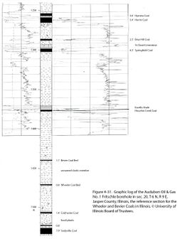
Core from Audubon Oil & Gas No. A-1 Fritschle in Jasper County provides a reference section for the Bevier Coal in Illinois (Figure 4-31). In this core, the Bevier is 1.1 ft (34 cm) thick at a depth of 1,439.2 to 1,440.3 ft (438.7 to 439.0 m). Coal has been removed from the core but is noted on the company core description and indicated on gamma-ray, density, and resistivity logs.
Reference author(s)
This report.
Reference status
Logs of the Fritschle borehole are on file at the Geological Records Unit of the ISGS and can be downloaded from the ISGS website. Core is stored in the ISGS Geological Samples Library in Champaign under storage number C-15260.
Stratigraphic relationships
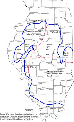
The Bevier Coal is hereby extended from Missouri into the Illinois Basin. The Bevier Coal is ranked as a member where it is separate from the older Wheeler Coal. Where the two seams merge, they become beds within the Survant Coal Member.
Extent and thickness
The Bevier Coal is present throughout the Illinois Basin east of the Du Quoin Monocline and its northward extension but is generally absent from the Western Shelf (Figure 4-34). Its thickness is 1 to 3 ft (30 to 90 cm) in most of the Fairfield Basin.
Lithology
Like the Wheeler, this is a bright-banded coal that lacks unusual or distinctive features. Also like the Wheeler, the Bevier lacks an overlying marine unit in the Fairfield Basin.
Core(s)
Photograph(s)
Contacts
Ordinarily, both contacts are sharp.
Well log characteristics
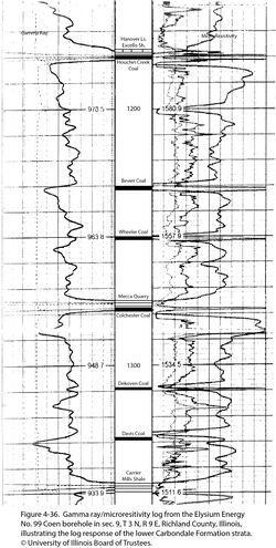
Typical for coal. In cases where the coal is thin or absent, its position often can be pinpointed at the sharp inflection between two upward-coarsening sequences (Figure 4-36).
Fossils
Peppers (1970) investigated the palynology of the Lowell, Shawneetown, Cardiff, and Coal IV (Survant) of Indiana and reported that all four were closely similar to one another and distinct from the older Colchester and younger Houchin Creek Coals.
Age and correlation
The age is middle Desmoinesian. Correlative coal has not been identified outside the Illinois and Midcontinent Basins.
Environments of deposition
The Wheeler and Bevier Coals both represent extensive coastal peat deposits that developed during separate eustatic cycles of sedimentation. Sea-level fluctuations were of relatively low amplitude. One hypothesis is that the Wheeler peat accumulated on an uneven surface that included abandoned river channels. Upon transgression, the entire peat deposit was submerged, but clastic sediment accumulated only in the depressions. As the sea level dropped, the climate changed back to ever-wet and peat accumulation (Bevier) resumed on a nearly level surface. An alternate model is that peat accumulation (perhaps in raised bogs) was continuous from Wheeler through Bevier time in areas of slow subsidence, whereas the peat was drowned and covered with a wedge of clastic sediment in more rapidly sinking basinal areas (David A. Williams, Kentucky Geological Survey, written communication, 2017).
Economic importance
Mining of the Bevier Coal in the Illinois Basin has been almost entirely confined to areas where the Wheeler and Bevier have merged as the Survant Coal.
Remarks
References
- Gentile, R.J., and T.L. Thompson, 2004, Paleozoic succession in Missouri, Part 5, Pennsylvanian Subsystem, Volume A, Morrowan strata through Cherokee Group: Missouri Geological Survey, Report of Investigations 70, 241 p. and correlation chart.
- Howe, W.B., and J.W. Koenig, 1961, The stratigraphic succession in Missouri: Missouri Geological Survey and Water Resources, v. 40, 2nd Series, 183 p. and chart.
- McGee, W.J., 1888, Notes on the geology of Macon County, Missouri: Transactions of the St. Louis Academy of Science, v. 5, p. 305–336.
- Peppers, R.A., 1970, Correlation and palynology of coals in the Carbondale and Spoon Formations (Pennsylvanian) of the northeastern part of the Illinois Basin: Illinois State Geological Survey, Bulletin 93, 173 p.
- Pope, J.P., 2012, Description of Pennsylvanian units, revision of stratigraphic nomenclature, and reclassification of the Morrowan, Atokan, Desmoinesian, Missourian, and Virgilian stages in Iowa: Iowa Geological and Water Survey, Special Report Series No. 5, 140 p.
- Ravn, R.L., J.W. Swade, M.R. Howes, J.L. Gregory, R.R. Anderson, and P.E. Van Dorpe, 1984, Stratigraphy of the Cherokee Group and revision of Pennsylvanian stratigraphic nomenclature in Iowa: Iowa Geological Survey, Technical Information Series No. 12, 76 p.
- Wright, C.R., 1965, Environmental mapping of the beds of the Liverpool cyclothem in the Illinois Basin and equivalent strata of the northern mid-continent region: Urbana, University of Illinois, Ph.D. thesis, 100 p.
ISGS Codes
| Stratigraphic Code | Geo Unit Designation |
|---|---|


