Dekoven Coal Member or Bed
Lithostratigraphy: Carbondale Formation >>Dekoven Coal Member
Chronostratigraphy: Paleozoic Erathem >>Pennsylvanian Subsystem >>Desmoinesian Series
Allostratigraphy: Absaroka Sequence
Primary source
Nelson, W.J., P.H. Heckel and J.M. Obrad, 2022, Pennsylvanian Subsystem in Illinois: Illinois State Geological Survey, Bulletin (in press).
Contributing author(s)
W.J. Nelson
Name
Original description
Lee (1916, p. 30–31, 65–66) applied the name “Dekoven coal bed” to the seam that Owen called “3-foot coal” or “No. 6.” In addition, Lee revised the Dekoven to Western Kentucky No. 7, which is the current informal usage. Butts (1925) was the first author to discuss the Dekoven Coal in Illinois.
Derivation
Dekoven is an unincorporated community in Union County, Kentucky.
Other names
Prior to 1916, the Dekoven was called the 3-foot coal or No. 6 in western Kentucky. In Illinois, some authors called the Davis and Dekoven the No. 2 and No. 3 coals, respectively.
History/background
According to Wikipedia (accessed September 17, 2018), “In 1843 a native of Flanders, Belgium started a coal mining operation. He named the community DeKoven, Flemish for ‘a camp or village among the hills.’ A post office was established in 1871, and the post office was discontinued after 1938.” Some authors, including Willman et al. (1975), rendered the name “De Koven,” but “Dekoven” has been the normal spelling since the time of Lee (1916) and likely dates from establishment of the post office.
Type section
No type section was proposed. When Lee (1916) conducted his field study, he stated that no fresh exposures were available.
Reference section
Reference location
The principal reference section for the Dekoven Coal is the same as that for the Davis Coal: Kentucky Geological Survey borehole Gil 15 drilled in Carter section 5-M-18, Union County, Kentucky. The Dekoven Coal is about 3.2 ft (97 cm) thick and occupies the depth interval from 139.4 to 142.6 ft (42.5 to 43.5 m; Figure 4-13).
Reference author(s)
This report. Williams et al. (1982) published the core description.
Reference status
Original logs are on file with the Kentucky Geological Survey; the core resides at the Kentucky Geological Survey core facility in Lexington.
Stratigraphic relationships
See discussion of the Seelyville Coal Member. The Dekoven is considered a member where it is separated from the older Davis Coal by siliciclastic strata. Where it is a component of the Seelyville Member, the Dekoven is classified as a bed.
Extent and thickness
Kehn (1974) reported a thickness range of 12 to 48 in. (30 to 122 cm) in the type area. In southeastern Illinois, the Dekoven Coal ranges from a streak to at least 66 in. (168 cm) thick, but it maintains a thickness of 30 in. (91 cm) or greater across large areas. Estimated resources are about 6 billion tons (about 5.44 billion metric tons), amounting to 3% of the total coal in the state and ranking seventh among the seams (Korose et al. 2002).
Lithology
Not much information has been published about the Dekoven Coal in Kentucky. Lee (1916) observed that the underclay tends to be thin and that the immediate roof is micaceous, carbonaceous shale containing leaf fragments. Greb et al. (1992) stated that the Dekoven tends to become thin and discontinuous southeastward along the outcrop. These authors further indicated that the Dekoven has frequently been confused with both the Davis and Colchester Coals and that splitting of either the Davis or Dekoven complicates the picture. Jacobson (1987, 1993) correctly indicated that the Dekoven undergoes splitting, whereas the Davis does not. The lower and upper “benches” of “split” Dekoven Coal are here designated the Greenbush and Abingdon Coals, respectively. But where the Dekoven is a single seam, there is commonly not even a parting to mark the division between Greenbush and Abingdon.
Like the Davis, the Dekoven is bright-banded coal and has well-developed cleat. Pyrite occurs as lenses and laminae. Among 23 analyses, the Dekoven averaged 11% ash (range of 8.0 to 16.8%) and 3.7% sulfur (range of 1.3 to 5.3%). Both values are higher than for the Davis, and the heating value of the Dekoven is correspondingly lower (Jacobson 1993).
Core(s)
Photograph(s)
Contacts
Both contacts typically are sharp.
Well log characteristics
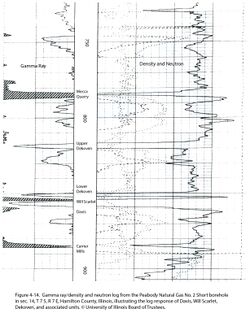
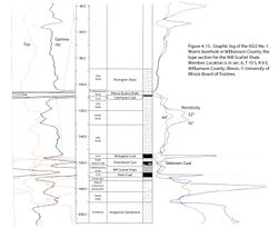
Typical for coal (Figures 4-14 and 4-15).
Fossils
Kosanke (1950) and Peppers (1970) discussed palynology and the correlation of the Dekoven and related coal beds.
Age and correlation
Like the Seelyville Coal Member, the age is near the middle of the Desmoinesian Series. When a process of elimination is used, the Dekoven probably correlates with the Robinson Branch Coal Bed of Missouri and Kansas.
Environments of deposition
The Dekoven represents the merger of two regionally extensive peat deposits. Remarkably, in many places there is no clastic layer to mark the division between the two.
Economic importance
The Dekoven Coal has been mined extensively in western Kentucky and in Gallatin and Saline Counties, southeastern Illinois. Nearly all activity in Illinois has been in surface mines, where the Dekoven and Davis seams were extracted together. Remaining resources of 5.92 billion tons (5.37 billion metric tons) have been calculated in Illinois (Keystone 2010).
Remarks
References
- Butts, C., 1925, Geology and mineral resources of the Equality-Shawneetown area: Illinois State Geological Survey, Bulletin 47, 76 p., 2 pls.
- Greb, S.F., D.A. Williams, and A.D. Williamson, 1992, Geology and stratigraphy of the western Kentucky coal field: Kentucky Geological Survey, Series 11, Bulletin 2, 77 p., 1 pl.
- Jacobson, R.J., 1987, Stratigraphic correlations of the Seelyville, Dekoven, and Davis Coals of Illinois, Indiana, and western Kentucky: Illinois State Geological Survey, Circular 539, 27 p. and 2 pls.
- Jacobson, R.J., 1993, Coal resources of the Dekoven and Davis Members (Carbondale Formation) in Gallatin and Saline Counties, southeastern Illinois: Illinois State Geological Survey, Circular 551, 41 p., 5 pls.
- Kehn, T.M., 1974, Geologic map of parts of the Dekoven and Saline Mines Quadrangles, Crittenden and Union Counties, Kentucky: U.S. Geological Survey, Geologic Quadrangle Map GQ-1147, 1 sheet, 1:24,000.
- Keystone, 2010, Keystone Coal Industry manual: Jacksonville, Florida, Mining Media International, 631 p.
- Korose, C.P., C.G. Treworgy, R.J. Jacobson, and S.D. Elrick, 2002, Availability of the Danville, Jamestown, Dekoven, Davis, and Seelyville Coals for mining in selected areas of Illinois: Illinois State Geological Survey, Illinois Minerals 124, 44 p.
- Kosanke, R.M., 1950, Pennsylvanian spores of Illinois and their use in correlation: Illinois State Geological Survey, Bulletin 74, 128 p., 2 pls.
- Lee, W., 1916, Geology of the Kentucky part of the Shawneetown Quadrangle: Kentucky Geological Survey, Series 4, Bulletin 4, Part 2, 73 p.
- Peppers, R.A., 1970, Correlation and palynology of coals in the Carbondale and Spoon Formations (Pennsylvanian) of the northeastern part of the Illinois Basin: Illinois State Geological Survey, Bulletin 93, 173 p.
- Williams, D.A., A.D. Williamson, and J.G. Beard, 1982, Stratigraphic framework of coal-bearing rocks in the western Kentucky coal Field: Kentucky Geological Survey, Series 11, Information Circular 8, 201 p.
- Willman, H.B., E. Atherton, T.C. Buschbach, C. Collinson, J.C. Frye, M.E. Hopkins, J.A. Lineback, and J.A. Simon, 1975, Handbook of Illinois stratigraphy: Illinois State Geological Survey, Bulletin 95, 261 p.
ISGS Codes
| Stratigraphic Code | Geo Unit Designation |
|---|---|


