Gentry Coal Bed
Lithostratigraphy: Raccoon Creek Group >>Caseyville Formation >>Gentry Coal Bed
Chronostratigraphy: Paleozoic Erathem >>Pennsylvanian Subsystem >>Morrowan Series
Allostratigraphy: Absaroka Sequence
Primary source
Nelson, W.J., P.H. Heckel and J.M. Obrad, 2022, Pennsylvanian Subsystem in Illinois: Illinois State Geological Survey, Bulletin (in press).
Contributing author(s)
W. J. Nelson
Name
Original description
Owen (1856, No. 1 vertical section) first observed this unit and named it the Battery Rock coal.
Derivation
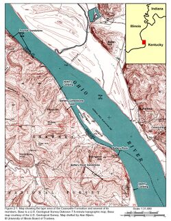
The coal was named for Gentry (or Gentry’s) Landing on the Ohio River in Hardin County, Illinois (Figure 2-1). Older versions of the Shawneetown 15-minute topographic map locate Gentry Landing south of Battery Rock in the NW¼ of sec. 35, T11S, R10E.
Other names
Battery Rock coal was used until 1960.
History/background
The name Battery Rock coal persisted until Kosanke et al. (1960) changed the name to Gentry Coal Member to avoid duplication with Battery Rock Sandstone. Nelson et al. (1991) demoted the Gentry in rank from a member to a bed because the coal is thin and local in extent.
Type section
Type location
According to Kosanke et al. (1960), the stratotype resides just south of Battery Rock in SW¼, sec. 26, T11S, R10E, Hardin County. This section has not been described in print, and ISGS field notes for the area do not mention coal. However, Baxter et al. (1963, p. 25) reported that the coal is best exposed northwest of Battery Rock in the SW¼ NE¼ of sec. 27, in the same township where Worthen and Englemann (1866, p. 360–361) described the coal in some detail and fixed its stratigraphic position. Pending further field work in the area, the site identified by Baxter et al. (1963) is hereby considered the type locality.
Type author(s)
See above.
Type status
Tentative, pending further investigation.
Reference section
None.
Stratigraphic relationships
Most authors are rather vague in locating the Battery Rock/Gentry Coal. The most definite statement is found in Worthen and Englemann (1866, p. 360–361), who wrote, “Above the lower sandstone at Battery Rock there is about 60 ft [18 m] of shale, then the Battery Rock coal seam, capped by shales and sandstone.” From the map by Baxter et al. (1963), the “lower sandstone” is what is presently called the Battery Rock Sandstone Member. In the Caseyville type section described by Lee (1916), the Battery Rock coal appears considerably higher above the conglomeratic sandstone (Figure 2-1), but if the thinly bedded sandstone above the conglomerate is considered part of the Battery Rock Member, then Lee (1916) is more nearly in agreement with Worthen and Englemann (1866).
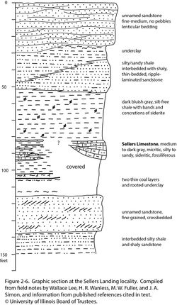
Baxter et al. (1963) believed the Gentry Coal to be younger than the Sellers Limestone, and their opinion carried forward to Willman et al. (1975). However, Lee’s (1916) section shows the limestone above the coal. Baxter et al. (1963) mapped the top of the Battery Rock Sandstone near the base of the bluff at the Sellers type locality. With reference to field notes from the type Sellers Limestone locality, the Sellers lies a short distance above the Gentry Coal (Figure 2-6).
Nelson et al. (1991) reported coal within 10 ft (3 m) above the top of the Battery Rock Sandstone at several localities in Johnson and Pope Counties. Palynology of this coal, examined by R.A. Peppers, was similar to that of the type Gentry. A younger coal bed a short distance beneath the Pounds Sandstone contained a spore flora distinct from that of the Gentry.
In summary, the Gentry Coal is difficult to trace and correlate, even close to the type section. The coal appears to be low in the shaly interval between Battery Rock and Pounds Sandstones and is older than the Sellers Limestone.
Extent and thickness
Worthen and Englemann (1866) reported that the coal averaged about 26 in. (66 cm) thick near Battery Rock and was being mined from small drifts. Nelson et al. (1991) reported a thickness range of 14 to 24 in. (36 to 61 cm) in Pope and eastern Johnson County. Coal identified as Gentry is known from only a few localities in far southern Illinois and adjacent Kentucky, where it has been called Battery Rock coal (Kehn 1974).
Lithology
Worthen and Englemann (1866) stated that the lower 1 to 6 in. (2.5 to 15 cm) is shaly. Nelson et al. (1991) found that all except the uppermost few inches of the Gentry is shaly. The floor is gray claystone or siltstone, and the roof is gray shale, grading upward to sandstone.
Core(s)
Photograph(s)
Contacts
The lower contact tends to be gradational and the upper contact sharp.
Well log characteristics
Presumably typical for coal with a muted log response because of the high shale content.
Fossils
Peppers (1996) published a list of spore taxa and percentages from the type locality of the Gentry Coal. A sample of “Battery Rock coal” from across the river in Union County, Kentucky, yielded a different flora. This discrepancy may indicate that the two coals are not correlative or that the coals represent local, discontinuous mires, each with different floras controlled by local edaphic conditions.
Age and correlation
On the basis of palynology, the Gentry Coal approximately correlates with the top of the New River Formation in West Virginia (Peppers 1996).
Environments of deposition
The consistent shaly nature of the lower part of the seam suggests a transition from an early clastic swamp to a later peat swamp, possibly reflecting increasingly humid climate, a rising water table, or both. Most likely, peat accumulated in isolated low spots on the landscape.
Economic importance
This bed formerly was mined on a small scale for local use.
Remarks
References
- Baxter, J.W., P.E. Potter, and F.L. Doyle, 1963, Areal geology of the Illinois fluorspar district: Part 1—Saline Mines, Cave in Rock, Dekoven, and Repton Quadrangles: Illinois State Geological Survey, Circular 342, 43 p., 2 pls., 1 map sheet, 1:24,000.
- Kehn, T.M., 1974, Geologic map of parts of the Dekoven and Saline Mines Quadrangles, Crittenden and Union Counties, Kentucky: U.S. Geological Survey, Map GQ-1147, 1:24,000.,br>
- Kosanke, R.M., J.A. Simon, H.R. Wanless, and H.B. Willman, 1960, Classification of the Pennsylvanian strata of Illinois: Illinois State Geological Survey, Report of Investigations 214, 84 p., 1 pl.
- Lee, W., 1916, Geology of the Shawneetown Quadrangle in Kentucky: Kentucky Geological Survey, Ser. 4, v. 4, part 2, 73 p.
- Nelson, W.J., J.A. Devera, R.J. Jacobson, D.K. Lumm, R.A. Peppers, B. Trask, C.P. Weibel, L.R. Follmer, M.H. Riggs, S.P. Esling, E.D. Henderson, and M.S. Lannon, 1991, Geology of the Eddyville, Stonefort, and Creal Springs Quadrangles, southern Illinois: Illinois State Geological Survey, Bulletin 96, 85 p., 1 pl.
- Owen, D.D., 1856, Report of the geological survey of Kentucky made during the years 1854 and 1855: The American Journal of Science. Ser. 2, v. 23, p. 272–276.
- Peppers, R.A., 1996, Palynological correlation of major Pennsylvanian (Middle and Upper Carboniferous) chronostratigraphic boundaries in the Illinois and other coal basins: Geological Society of America, Memoir 188, 111 p., correlation chart.
- Willman, H.B., E. Atherton, T.C. Buschbach, C. Collinson, J.C. Frye, M.E. Hopkins, J.A. Lineback, and J.A. Simon, 1975, Handbook of Illinois stratigraphy: Illinois State Geological Survey, Bulletin 95, 261 p.,br>
- Worthen, A.H., and H. Engelmann, 1866, Geology of Hardin County, in A.H. Worthen, ed., Geological Survey of Illinois, v.1: Geology: Springfield, State Journal Steam Press, p. 350–375.
ISGS Codes
| Stratigraphic Code | Geo Unit Designation |
|---|---|

