Search results
Jump to navigation
Jump to search
Page title matches
File:Figure M-49.jpg (1,080 × 1,070 (228 KB)) - 14:29, 4 April 2016
File:Figure M-15.jpg (3,256 × 2,220 (847 KB)) - 13:59, 4 April 2016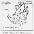
File:Figure M-47.jpg (1,085 × 1,106 (249 KB)) - 14:27, 4 April 2016
File:Figure M-26.jpg (2,231 × 3,280 (923 KB)) - 14:08, 4 April 2016
File:Figure M-5.jpg (1,062 × 1,513 (257 KB)) - 13:24, 4 April 2016
File:Figure M-37.jpg (1,089 × 1,609 (256 KB)) - 14:20, 4 April 2016
File:Figure M-16.jpg (1,086 × 1,404 (306 KB)) - 14:00, 4 April 2016
File:Figure M-48.jpg (1,061 × 1,086 (233 KB)) - 14:28, 4 April 2016
File:Figure M-27.jpg (2,261 × 3,052 (848 KB)) - 14:10, 4 April 2016
File:Figure M-6.jpg (1,073 × 2,715 (325 KB)) - 13:24, 4 April 2016
File:Figure M-38.jpg (1,067 × 1,596 (245 KB)) - 14:21, 4 April 2016
File:Figure M-17.jpg (1,077 × 1,486 (251 KB)) - 14:01, 4 April 2016
File:Figure M-28.jpg (2,245 × 3,047 (718 KB)) - 14:12, 4 April 2016
File:Figure M-7.jpg (3,183 × 1,092 (391 KB)) - 13:25, 4 April 2016
File:Figure M-39.jpg (1,073 × 1,434 (210 KB)) - 14:22, 4 April 2016
File:Figure M-18.jpg (1,076 × 1,464 (254 KB)) - 14:01, 4 April 2016
File:Figure M-50.jpg (1,078 × 1,088 (223 KB)) - 14:29, 4 April 2016
File:Figure M-29.jpg (1,794 × 3,419 (687 KB)) - 14:12, 4 April 2016
File:Figure M-8.jpg (1,085 × 1,561 (400 KB)) - 13:30, 4 April 2016
File:Figure M-40.jpg (1,065 × 1,454 (235 KB)) - 14:22, 4 April 2016


Page text matches
File:C605-Figure-09.jpg |File name=C605-Figure-09.jpg |image_no=Figure 9(1,578 × 1,585 (969 KB)) - 15:54, 11 July 2020- ...d-coarsening sediments of the Delafield Member ([[:File:C605-Figure-49.jpg|Figure 49]]). This part of the model is similar to past cyclothem models in the Il ...style="display: inline-block;">[[File:C605-Figure-49.jpg|500px|{{File:C605-Figure-49.jpg}}|thumb]]</li>12 KB (1,677 words) - 15:13, 23 August 2023
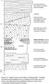
File:Penn caseyville 2-6.jpg Figure 2-6. Graphic section at the Sellers Landing locality. Compiled from field n(1,587 × 2,727 (886 KB)) - 16:19, 20 July 2020
File:C605-Figure-27.jpg |File name=C605-Figure-27.jpg |image_no=Figure 27(1,418 × 1,307 (196 KB)) - 15:59, 17 August 2023- ...ay: inline-block;"> [[File:C605-Figure-04.jpg|thumb|left|500px|{{File:C605-Figure-04.jpg}}]]</li> ...profile is characteristic on resistivity logs ([[:File:C605-Figure-05a.jpg|Figure 5a]]). The Houchin Creek evidently represents an ''in situ'' peat deposit t2 KB (312 words) - 20:47, 23 August 2023
- ...3 ft (319.5 m) to the top of the Hanover Limestone at 1,123.2 ft (342.4 m; Figure 4-49). ...to the Delafield, or (2) the Springfield Coal Member, as in the type core (Figure 4-49). The relationship to the [[Covel Conglomerate Bed]] is uncertain.10 KB (1,464 words) - 16:37, 9 February 2022
- ...ified by very high readings on gamma-ray logs ([[:File:C605-Figure-05b.jpg|Figure 5]]) and low readings on density and neutron logs. ...style="display: inline-block;">[[File:C605-Figure-04.jpg|500px|{{File:C605-Figure-04.jpg}}|thumb]]</li>3 KB (509 words) - 20:54, 23 August 2023
- The Danville (Figures [[:File:C605-Figure-02.jpg|2]] and [[:File:C605-Figure-40.jpg|40]]) is the next major coal bed above the Baker. It is the youngest ...style="display: inline-block;">[[File:C605-Figure-02.jpg|500px|{{File:C605-Figure-02.jpg}}|thumb]]</li>3 KB (494 words) - 15:11, 23 August 2023
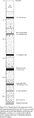
File:Penn carbondale 4-13.jpg |Caption=Figure 4-13. Graphic log of the upper part of the Kentucky Geological Survey’s(1,059 × 3,660 (466 KB)) - 21:07, 26 January 2021- ...h lies near its course. Comparing Potter’s map ([[:File:C605-Figure-30.jpg|Figure 30]]) with those of Hopkins (1968)<ref>Hopkins, M.E., 1968, Harrisburg (No. ...style="display: inline-block;">[[File:C605-Figure-01.jpg|500px|{{File:C605-Figure-01.jpg}}|thumb]]</li>7 KB (979 words) - 19:20, 23 August 2023
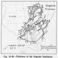
- ...Oraville channel (Figures [[:File:C605-Figure-39.jpg|39]] and [[:File:C605-Figure-47.jpg|47]]). In fact, coal of mineable thickness (up to 8.2 ft [2.5 m]) is ...style="display: inline-block;">[[File:C605-Figure-39.jpg|500px|{{File:C605-Figure-39.jpg}}|thumb]]</li>3 KB (504 words) - 20:15, 23 August 2023
- ...nklin, Hamilton, Saline, and Gallatin Counties ([[:File:C605-Figure-08.jpg|Figure 8]]). Widths are in the range of 0.6 to 1.9 mi (1 to 3 km). Portions appear ...style="display: inline-block;">[[File:C605-Figure-08.jpg|500px|{{File:C605-Figure-08.jpg}}|thumb]]</li>3 KB (493 words) - 19:38, 23 August 2023
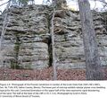
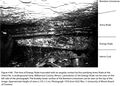
File:Penn caseyville 2-8.jpg Figure 2-8. Photograph of the Pounds Sandstone in Garden of the Gods State Park (S(2,201 × 2,002 (4.3 MB)) - 21:37, 24 November 2020- Figure M-1B.jpg|{{file:Figure M-1B.jpg}} Figure M-1D.jpg|{{file:Figure M-1D.jpg}}3 KB (473 words) - 15:25, 18 January 2017
File:Penn carbondale 4-80.jpg |Caption=Figure 4-80. Thin lens of Energy Shale truncated with an angular contact by the o(2,441 × 1,741 (1.54 MB)) - 21:38, 4 January 2021- Figure P-2.jpg|{{file:Figure P-2.jpg}} Figure P-5.jpg|{{file:Figure P-5.jpg}}3 KB (397 words) - 21:41, 2 March 2018
- Figure P-16.jpg|{{file:Figure P-16.jpg}} Figure P-2.jpg|{{file:Figure P-2.jpg}}3 KB (441 words) - 22:23, 19 January 2017
- ...ay: inline-block;"> [[File:C605-Figure-04.jpg|thumb|left|500px|{{File:C605-Figure-04.jpg}}]]</li> ...grades downward to siltstone or silty mudstone ([[:File:C605-Figure-09.jpg|Figure 9]]). All except the uppermost 1.0 to 2.0 ft (0.3 to 0.6 m) is generally ca4 KB (633 words) - 16:27, 23 August 2023
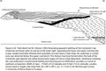
File:Penn carbondale 4-20.jpg |Caption=Figure 4-20. Field sketch by W.J. Nelson (1983) illustrating apparent splitting o(2,391 × 1,614 (778 KB)) - 21:44, 22 December 2020- Figure 14.jpg|{{file:Figure 14.jpg}} Figure P-3D.jpg|{{file:Figure P-3D.jpg}}3 KB (482 words) - 22:16, 19 January 2017


