Search results
Jump to navigation
Jump to search
Page title matches
- |category4=Soil |tree1=Afton Soil6 KB (858 words) - 17:09, 4 January 2017
- |tree1=Sangamon Soil |category4=Soil10 KB (1,487 words) - 22:23, 3 January 2017
- |category4=Soil |tree1=Yarmouth Soil8 KB (1,197 words) - 22:33, 12 January 2017
- |tree1=Chapin Soil |category4=Soil3 KB (492 words) - 22:23, 3 January 2017
- |category4=Soil |tree1=Pike Soil4 KB (661 words) - 22:26, 12 January 2017
- |category4=Soil |tree1=Sangamon Soil10 KB (1,550 words) - 21:13, 12 January 2017
- |tree1=Farmdale Soil |category4=Soil7 KB (991 words) - 22:20, 3 January 2017
- |category4=Soil |tree1=Chapin Soil4 KB (556 words) - 20:59, 12 January 2017
- |tree1=Afton Soil |category4=Soil5 KB (797 words) - 16:19, 4 January 2017
- |tree1=Yarmouth Soil |category4=Soil7 KB (1,133 words) - 22:43, 3 January 2017
- |category4=Soil |tree1=Farmdale Soil7 KB (1,054 words) - 20:38, 12 January 2017
- |tree1=Pike Soil |category4=Soil4 KB (591 words) - 22:14, 3 January 2017
- |category4=Soil |tree1=Jules Soil3 KB (435 words) - 20:36, 12 January 2017
- |tree2=Little Bear Soil The Little Bear Soil (Mellen, 1937, p. 8-20), a soil locally preserved at the base of the Cretaceous System, is named for Little2 KB (272 words) - 21:43, 23 November 2016
- |tree1=Modern Soil This unit has long been called "Modern Soil," and it seems undesirable to replace it with a geographic name.2 KB (266 words) - 21:10, 6 September 2022
- |tree1=Modern Soil This unit has long been called "Modern Soil," and it seems undesirable to replace it with a geographic name.1 KB (206 words) - 05:22, 28 December 2016
- |tree2=Little Bear Soil The Little Bear Soil (Mellen, 1937, p. 8-20), a soil locally preserved at the base of the Cretaceous System.3 KB (345 words) - 16:36, 11 January 2017
- |tree1=Jules Soil |category4=Soil2 KB (366 words) - 06:42, 28 December 2016
- |tree1=Pleasant Grove Soil |category4=Soil3 KB (410 words) - 22:22, 3 January 2017
- |category4=Soil |tree1=Pleasant Grove Soil3 KB (477 words) - 20:46, 12 January 2017
Page text matches
File:Figure Q-1E.jpg ..., Sangamon Soil developed in the Illinoian Loveland Silt (SL) and Yarmouth Soil developed in till of the Kansan Banner Formation (YB); in a roadcut at Inde(2,000 × 1,529 (1.16 MB)) - 13:11, 5 April 2016
File:104-Figure 1 2.jpg Soil Stratigraphy(1,445 × 2,000 (307 KB)) - 15:47, 19 April 2016- |tree1=Modern Soil This unit has long been called "Modern Soil," and it seems undesirable to replace it with a geographic name.1 KB (206 words) - 05:22, 28 December 2016
- #REDIRECT [[Little Bear Soil ]]31 bytes (4 words) - 13:47, 29 April 2016
- |tree1=Chapin Soil |category4=Soil3 KB (492 words) - 22:23, 3 January 2017
- |tree1=Pleasant Grove Soil |category4=Soil3 KB (410 words) - 22:22, 3 January 2017
- |tree2=Little Bear Soil The Little Bear Soil (Mellen, 1937, p. 8-20), a soil locally preserved at the base of the Cretaceous System, is named for Little2 KB (272 words) - 21:43, 23 November 2016
- |tree1=Jules Soil |category4=Soil2 KB (366 words) - 06:42, 28 December 2016
- |tree1=Pike Soil |category4=Soil4 KB (591 words) - 22:14, 3 January 2017
- |tree1=Modern Soil This unit has long been called "Modern Soil," and it seems undesirable to replace it with a geographic name.2 KB (266 words) - 21:10, 6 September 2022
- |category4=Soil |tree1=Chapin Soil4 KB (556 words) - 20:59, 12 January 2017
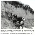
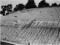
File:104-Figure 26.jpg Figure 26 -- Modern soil developed in diamicton of the Yorkville Member of the Lemont Formation abov(2,000 × 1,964 (1.29 MB)) - 17:19, 19 April 2016- |category4=Soil |tree1=Pleasant Grove Soil3 KB (477 words) - 20:46, 12 January 2017
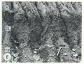
File:Figure Q-1F.jpg ...rkness Silt Member of the Kansan Banner Formation (Bh) overlying the Afton Soil developed on gravel of the Nebraskan Enion Formation (AE); in a roadcut at(2,000 × 1,529 (1.13 MB)) - 19:04, 22 April 2016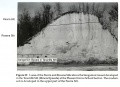
File:104-Figure 29.jpg ...e Silt (Illinois Episode) at the Pleasant Grove School Section. The modern soil is developed in the upper part of the Peoria Silt.(2,000 × 1,458 (1,015 KB)) - 17:50, 19 April 2016- |category4=Soil |tree1=Pike Soil4 KB (661 words) - 22:26, 12 January 2017
- |category4=Soil |tree1=Jules Soil3 KB (435 words) - 20:36, 12 January 2017
- |tree1=Afton Soil |category4=Soil5 KB (797 words) - 16:19, 4 January 2017
- |tree2=Little Bear Soil The Little Bear Soil (Mellen, 1937, p. 8-20), a soil locally preserved at the base of the Cretaceous System.3 KB (345 words) - 16:36, 11 January 2017
File:Figure Q-1A.jpg ...tion (Wd), Morton Loess(M), Robein and Roxana Silts (RR), and the Sangamon Soil (S) on till of the Illinoian Glasford Formation(G); in a railroad cut a mil(2,000 × 1,487 (735 KB)) - 16:04, 5 April 2016- |tree1=Farmdale Soil |category4=Soil7 KB (991 words) - 22:20, 3 January 2017
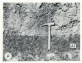
File:104-Figure 21.jpg ...emont Formation. The gamma B horizon represents an extension of the modern soil profile along joints to form a secondary zone of clay accumulation below th(2,000 × 956 (702 KB)) - 17:04, 19 April 2016- ...se sections contain the type localities for 21 rock-stratigraphic units, 4 soil-stratigraphic units, and 3 time-stratigraphic units and include paratypes f ...age of Illinoian Stage), and its upper boundary is the top of the Sangamon Soil, developed in the silts; it is overlain by the Roxana Silt. The term is not3 KB (495 words) - 22:26, 3 January 2017
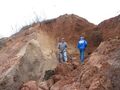
File:Fig 0870 Photos 002.JPG ...nois. Pictured are David Grimley (ISGS) left and Gerry Berning (USDA-NRCS, Soil Scientist) on the right, for scale. Sangamon Geosol development is visible(2,272 × 1,704 (1.15 MB)) - 22:06, 15 September 2022- |category4=Soil |tree1=Afton Soil6 KB (858 words) - 17:09, 4 January 2017
- |category4=Soil |tree1=Farmdale Soil7 KB (1,054 words) - 20:38, 12 January 2017
- |tree1=Yarmouth Soil |category4=Soil7 KB (1,133 words) - 22:43, 3 January 2017
- ...se sections contain the type localities for 21 rock-stratigraphic units, 4 soil-stratigraphic units, and 3 time-stratigraphic units and include paratypes f ...verlies the Chapin Soil and is terminated at the top by the Pleasant Grove Soil and the overlying Meadow Loess Member of the Roxana Silt.<br>4 KB (518 words) - 22:21, 3 January 2017
- ...se sections contain the type localities for 21 rock-stratigraphic units, 4 soil-stratigraphic units, and 3 time-stratigraphic units and include paratypes f ..., gray silt and fine sand at the top, overlying a weakly developed unnamed soil in the top of sand and gravel outwash, which in turn unconformably overlies4 KB (592 words) - 22:26, 3 January 2017
- |category4=Soil |tree1=Yarmouth Soil8 KB (1,197 words) - 22:33, 12 January 2017
- |tree1=Sangamon Soil |category4=Soil10 KB (1,487 words) - 22:23, 3 January 2017
- ...se sections contain the type localities for 21 rock-stratigraphic units, 4 soil-stratigraphic units, and 3 time-stratigraphic units and include paratypes f ...age of Illinoian Stage), and its upper boundary is the top of the Sangamon Soil, developed in the silts; it is overlain by the Roxana Silt. The term is not4 KB (562 words) - 21:57, 12 January 2017
- |category4=Soil |tree1=Sangamon Soil10 KB (1,550 words) - 21:13, 12 January 2017
- ...se sections contain the type localities for 21 rock-stratigraphic units, 4 soil-stratigraphic units, and 3 time-stratigraphic units and include paratypes f ...osition is commonly indistinguishable from that of the underlying Sangamon Soil B-zone. Other stratigraphic sections with this report describing the Markha5 KB (755 words) - 15:47, 18 November 2016
- ...se sections contain the type localities for 21 rock-stratigraphic units, 4 soil-stratigraphic units, and 3 time-stratigraphic units and include paratypes f ...verlies the Chapin Soil and is terminated at the top by the Pleasant Grove Soil and the overlying Meadow Loess Member of the Roxana Silt.<br>4 KB (584 words) - 20:46, 12 January 2017
- ...e Winslow Till is commonly bounded at the base by bedrock or by a residual soil developed in bedrock.2 KB (347 words) - 22:28, 3 January 2017
- ...se sections contain the type localities for 21 rock-stratigraphic units, 4 soil-stratigraphic units, and 3 time-stratigraphic units and include paratypes f ...ped in McDonough Loess and is terminated upward by the top of the Farmdale Soil or by the Robein Silt, Morton Loess, or Peoria Loess.4 KB (579 words) - 22:20, 3 January 2017
- ...rville Till Member, but more commonly it rests on bedrock or on a residual soil developed in bedrock. Further subdivision of the Ogle Member would appear t3 KB (413 words) - 22:27, 3 January 2017
- ...se sections contain the type localities for 21 rock-stratigraphic units, 4 soil-stratigraphic units, and 3 time-stratigraphic units and include paratypes f ..., gray silt and fine sand at the top, overlying a weakly developed unnamed soil in the top of sand and gravel outwash, which in turn unconformably overlies5 KB (658 words) - 22:01, 12 January 2017
- ...se sections contain the type localities for 21 rock-stratigraphic units, 4 soil-stratigraphic units, and 3 time-stratigraphic units and include paratypes f ...he top of the Yarmouth Soil and the upper boundary the top of the Sangamon Soil. The Loveland Silt is classified here as a formation.<br>6 KB (856 words) - 22:23, 3 January 2017
- ...se sections contain the type localities for 21 rock-stratigraphic units, 4 soil-stratigraphic units, and 3 time-stratigraphic units and include paratypes f ...e, by the top of the Yarmouth Soil. Its upper limit is the top of the Pike Soil (New Salem Northeast, Pleasant Grove Sections, table 6), the Duncan Mills M5 KB (773 words) - 22:14, 3 January 2017
- ...se sections contain the type localities for 21 rock-stratigraphic units, 4 soil-stratigraphic units, and 3 time-stratigraphic units and include paratypes f ...t was intermittently wet, and the entire deposit is considered an accreted soil.4 KB (578 words) - 22:48, 3 January 2017
- ...se sections contain the type localities for 21 rock-stratigraphic units, 4 soil-stratigraphic units, and 3 time-stratigraphic units and include paratypes f ...e section the Radnor Till is bounded at the top by the top of the Sangamon Soil. It is overlain by Roxana Silt and it rests on the Toulon Member. The Radno3 KB (472 words) - 22:26, 3 January 2017
- ...esence of the Sangamon Soil in the top of the Pearl, or, when the Sangamon Soil is missing, the presence of the Roxana Silt above the Pearl. <br> It consists of sand and gravel that has the Sangamon Soil in its top. It overlies Illinoian or older drift or bedrock. <br>4 KB (622 words) - 22:26, 3 January 2017
- ...se sections contain the type localities for 21 rock-stratigraphic units, 4 soil-stratigraphic units, and 3 time-stratigraphic units and include paratypes f ...osition is commonly indistinguishable from that of the underlying Sangamon Soil B-zone. Other stratigraphic sections with this report describing the Markha6 KB (818 words) - 21:04, 12 January 2017
- ...se sections contain the type localities for 21 rock-stratigraphic units, 4 soil-stratigraphic units, and 3 time-stratigraphic units and include paratypes f It rests on the Afton Soil developed in outwash and it is overlain by till of the Banner Formation of3 KB (489 words) - 16:09, 4 January 2017
- ...se sections contain the type localities for 21 rock-stratigraphic units, 4 soil-stratigraphic units, and 3 time-stratigraphic units and include paratypes f ...he top of the Yarmouth Soil and the upper boundary the top of the Sangamon Soil. The Loveland Silt is classified here as a formation.<br>6 KB (911 words) - 21:17, 12 January 2017
- ...se sections contain the type localities for 21 rock-stratigraphic units, 4 soil-stratigraphic units, and 3 time-stratigraphic units and include paratypes f ...ped in McDonough Loess and is terminated upward by the top of the Farmdale Soil or by the Robein Silt, Morton Loess, or Peoria Loess.5 KB (644 words) - 20:41, 12 January 2017
- ...se sections contain the type localities for 21 rock-stratigraphic units, 4 soil-stratigraphic units, and 3 time-stratigraphic units and include paratypes f ...e, by the top of the Yarmouth Soil. Its upper limit is the top of the Pike Soil (New Salem Northeast, Pleasant Grove Sections, table 6), the Duncan Mills M6 KB (833 words) - 22:28, 12 January 2017
- ...se sections contain the type localities for 21 rock-stratigraphic units, 4 soil-stratigraphic units, and 3 time-stratigraphic units and include paratypes f The silt rests on the Yarmouth Soil and is overlain by till of the Glasford Formation of Illinoian age. <br>4 KB (520 words) - 22:41, 3 January 2017


