Wedron Group
Lithostratigraphy: Wedron Group
Chronostratigraphy: Cenozoic Erathem >>Quaternary System >>Pleistocene Series
Primary source
Hansel, Ardith K., and W. Hilton Johnson, 1996, Wedron and Mason Groups: Lithostratigraphic Reclassification of Deposits of the Wisconsin Episode, Lake Michigan Lobe Area: Illinois State Geological Survey Bulletin 104, 116 p.
Contributing author(s)
Ardith K. Hansel and W. Hilton Johnson
Name
Original description
Wedron Formation (Frye et al. 1968).
Derivation
Wedron, a village along the Fox River in La Salle County, northeastern Illinois.
Other names
History/background
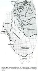
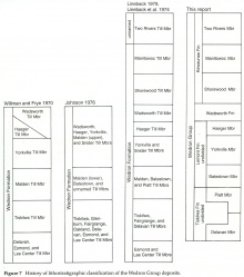
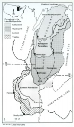
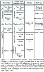
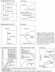
The Wedron Formation was originally defined by Frye et al. (1968), and later subdivided into members by Willman and Frye (1970; fig. 4b). Frye et al. defined the Wedron Formation as the succession of diamictons and associated sediments from the contact of the Morton Loess (or the Robein Silt in the absence of the Morton Loess) to the top of the diamicton below the Two Creeks deposit at Two Creeks, Wisconsin. Because several units within the succession are now recognized as formations (i. e., the Tiskilwa, Lemont, and Wadsworth), the Wedron is raised in rank to group status. Accepting the lithostratigraphic framework established for the Lake Michigan Lobe in Wisconsin by Mickelson et al. (1984), we classify the red till members (the Shorewood, Manitowoc, and Two Rivers) identified in Lake Michigan by Lineback et al. (1974) as members of the Kewaunee Formation of Wisconsin. The upper boundary of the original Wedron Formation is thus extended to include the Two Rivers Member of the Kewaunee Formation as part of the Wedron Group (fig. 7). Although the Wedron Group is defined on the basis of deposits in Illinois and Lake Michigan, the group also provides a useful regional concept (figs. 8, 11).
|
Type section
Type location
Wedron Section, Wedron Silica Company quarries at Wedron, Illinois; good for lower boundary and lithology (Tiskilwa Formation and lower part of Lemont Formation).
Type author(s)
Type status
Original section was destroyed by mining.
Reference section
Reference location
Farm Creek Section and Higginsville Section; good for lower boundary and lithology (Tiskilwa Formation). Land and Lakes Landfill Section; good for lithology (upper part of Lemont Formation and Wadsworth Formation). Cedarburg Lake Bluff Section and Kewaunee Section, Wisconsin; good for lithology (Kewaunee Formation and Wadsworth equivalent Oak Creek Formation).
Reference author(s)
Reference status
Stratigraphic relationships
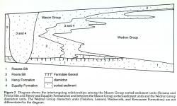
The Wedron Group comprises a succession of diamicton formations that interfinger with sorted-sediment formations of the Mason Group. The succession is subdivided from the base upward into the Tiskilwa, Lemont, Wadsworth, and Kewaunee Formations (fig. 7).
The Wedron Group is readily distinguishable from the sorted-sediment formations of the Mason Group. Diamicton units of the Wedron Group can generally be differentiated from those of the underlying formations on the basis of their lithic characteristics, but in some cases the stratigraphic relationships of Wedron diamicton to key pedostratigraphic units (like the Farmdale or Sangamon Geosols) are necessary. Lenses and bodies of material derived from the underlying units locally occur within the Wedron Group.
Extent and thickness
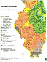
Except for the few areas where bedrock crops out, the Wedron Group is at or near the surface in northeastern Illinois (plate 1), northwestern Indiana, eastern Wisconsin, the western part of the lower peninsula of Michigan, and the Lake Michigan basin (fig. 8). The thickness of the Wedron Group varies. Although the Wedron Group may reach 75 to 90 meters (246-295 ft) thick in some of the larger moraines in Illinois, it averages about 30 meters (98 ft) thick in much of Illinois and locally is less than 1 meter thick in some regions of the Lake Michigan Lobe area.
Lithology
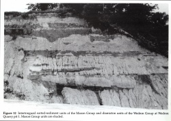
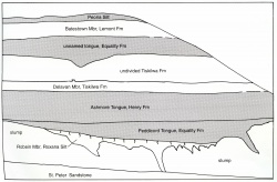
The Wedron Group consists of multiple diamicton units that contain lenses of clay, silt, sand, gravel, and occasionally humic material and wood. It intertongues with sorted sediment units of the Mason Group (fig. 2), most commonly the Peoria Silt and Henry and Equality Formations (figs. 9, 12). The succession contains considerable lithic heterogeneity among diamicton units. Matrix texture of diamicton ranges from fine to coarse, and the percentage of gravel-sized clasts ranges from about 2% to 5% in fine grained diamicton to up to 20% in coarse grained diamicton. Matrix diamicton color ranges from gray to gray brown, red gray, or red brown, and typically oxidizes to olive brown, brown, yellow brown, or red brown. The Wedron Group is subdivided into four formations and eight members in Illinois and Lake Michigan (fig. 7). The entire Wedron Group succession is not known to be present in any one place. From the base upward the ideal succession includes the following:
Tiskilwa Formation consisting of red to gray, medium textured diamicton units;
Lemont Formation consisting of a succession of gray, fine to coarse textured diamicton units;
Wadsworth Formation consisting of gray, fine grained diamicton units;
Kewaunee Formation containing red, fine textured diamicton units.
All the formations contain lenses of sorted sediment and intertongue, at least locally along their margins, with stratified sand and gravel of the Henry Formation and bedded silt and clay of the Equality Formation.
|
Core(s)
Photograph(s)
Contacts
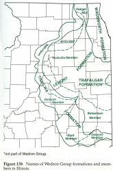
Lower boundary: the contact with the Ashmore Tongue of the Henry Formation, the Peddicord Tongue of the Equality Formation, the Morton Tongue of the Peoria Silt, the Robein Member or undivided Roxana Silt, or older units. Upper boundary: the contact with upper tongues of the Peoria Silt and Henry and Equality Formations, the Trafalgar Formation (fig. 13b), or postglacial units.
Well log characteristics
Fossils
Age and correlation
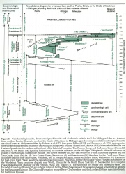
The Wedron Group was deposited during the Michigan Subepisode, between about 26,000 and 11,000 radiocarbon years ago (fig. 10). It correlates with equivalent units of the Lake Michigan Lobe (fig. 11) in Wisconsin (i. e., Tiskilwa Member, Zenda Formation; New Berlin Member, Holy Hill Formation; Oak Creek Formation; and Kewaunee Formation), in Indiana (i. e., Fairgrange, Batestown, Snider, and Wadsworth Tills), and in Michigan (i. e., Ganges, Saugatauk, Filer, Montague, Riverton, and Orchard Beach tills).
|
Environments of deposition
The Wedron Group consists predominantly of till that contains lenses of subglacial and supraglacial fluvial, lacustrine, and debris-flow sediment. This sediment together with intertonguing proglacial eolian, lacustrine, and fluvial sediment of the Mason Group makes up multiple glacigenic sequences. The glacigenic sequences have a shingled occurrence, and they pinch out in the subsurface beneath younger sequences. Rarely do more than two or three glacigenic sequences occur in succession, and most sections expose only parts of one or two sequences.
Economic importance
Remarks
Revised unit. Elevated in rank from the Wedron Formation (Frye et al. 1968, Willman and Frye 1970); upper boundary extended to top of the Two Rivers Member of the Kewaunee Formation (Mickelson et al. 1984); the Esmond and Lee Center Till Members now classified as the Glasford Formation (Berg et al. 1985).
References
BERG, R. C., J. P. KEMPTON, L. R. FOLLMER, and D .P. McKENNA, 1985, Illinoian and Wisconsinan Stratigraphy and Environments in Northern Illinois— The Altonian Revised: Illinois State Geological Survey Guidebook 19, 177 p.
FRYE, J. C., H. B. WILLMAN, M. RUBIN, and R. F. BLACK, 1968, Definition of Wisconsinan Stage: U.S. Geological Survey Bulletin 1274-E, p. E1-E22.
LINEBACK, J. A., D. L. GROSS, and R. P. MEYER, 1974, Glacial Tills Under Lake Michigan: Illinois State Geological Survey Environmental Geology Notes 69, 48 p.
MICKELSON, D. M., L. CLAYTON, R. W. BAKER, W. H. MODE, and A. F. SCHNEIDER, 1984, Pleistocene Stratigraphic Units of Wisconsin: Wisconsin Geological and Natural History Survey Miscellaneous Paper 84-1, 107 p.
WILLMAN, H. B., and J. C. FRYE, 1970, Pleistocene Stratigraphy of Illinois Illinois State Geological Survey Bulletin 94, 204 p.
ISGS Codes
| Stratigraphic Code | Geo Unit Designation |
|---|---|
