Vermilionville Sandstone Member
Lithostratigraphy: Carbondale Formation >>Vermilionville Sandstone Member
Chronostratigraphy: Paleozoic Erathem >>Pennsylvanian Subsystem >>Desmoinesian Series
Allostratigraphy: Absaroka Sequence
Primary source
Nelson, W.J., P.H. Heckel and J.M. Obrad, 2022, Pennsylvanian Subsystem in Illinois: Illinois State Geological Survey, Bulletin (in press).
Contributing author(s)
W.J. Nelson
Name
Original description
Discussing the stratigraphy of the LaSalle–Minonk coalfield in northern Illinois, Cady (1915, p. 29) introduced the name “Vermilionville sandstone” for a “heavy sandstone of variable thickness” and uncertain stratigraphic position. A photograph on page 29 bears the caption, “The heavy sandstone below coal No. 5 (Vermilionville sandstone) outcropping along the big bend in Vermilion River between Deer Park and Lowell.”
Derivation
The unincorporated community of Vermilionville is on the northeast side of the river about 7 mi (11 km) southeast of LaSalle.
Other names
The Cuba Sandstone (Savage 1927) and the Waupecon Sandstone (Culver 1922) are junior synonyms of Vermilionville. Usage of “Waupecon Sandstone” never found favor. “Cuba Sandstone” was used in western Illinois (e.g., Wanless 1957) until Kosanke et al. (1960) abandoned this name on the basis of priority.
History/background
None.
Type section
Type location
Along the Vermilion River just south of Vermilionville in SE¼ sec. 9, T 32 N, R 2 E, LaSalle County, Starved Rock 7.5' quadrangle.
Type author(s)
Wanless (1956) and Kosanke et al. (1960) listed the locality. No description has been published, and none exists in ISGS field notes. In fact, these notes suggest that the Vermilionville Sandstone does not exist at the stated locality.
Type status
Unknown.
Reference section(1)


Reference location
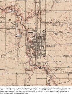
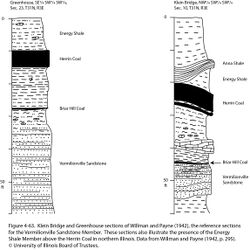
North bank of the Vermilion River east of Klein Bridge, NW¼ SW¼ SW¼ sec. 10, T 31 N, R 3 E, LaSalle County (Figures 4-62 and 4-63).
Reference author(s)
Willman and Payne (1942, geologic section 19, p. 295; Figure 4-63).
Reference status
The river bluff sections have good potential for long-term exposure.
Reference section(2)
Reference location
East bank of the Vermilion River “at greenhouse,” SE¼ SW¼ SW¼ sec. 23, T 31 N, R 3 E, LaSalle County (Figures 4-62 and 4-63).
Reference author(s)
Willman and Payne (1942, geologic section 20, p. 295; Figure 4-63).
Reference status
The river bluff sections have good potential for long-term exposure.
Reference section(3)
Reference location
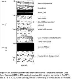
Small ravine, E½ SE¼ sec. 8, T 6 N, R 3 E, Fulton County. Identity of Herrin and Springfield Coals and associated marine units is unquestionable. The Vermilionville Sandstone (Cuba Sandstone of Wanless) rests on Turner Mine Shale with erosive contact (Figure 4-64). Wanless stated that the sandstone thickens to at least 20 ft (6 m) about 1 mi (1.6 km) west of this locality. Note that a paleosol, including claystone and limestone bearing root impressions, lies between the Vermilionville and Herrin Coal. The paleosol likely represents underclay of the Briar Hill Coal.
Reference author(s)
Wanless (1957, geologic section 44, p. 207).
Reference status
Unknown.
Stratigraphic relationships

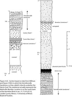
Authors have long disagreed on the stratigraphic position of this unit. Cady (1915, 1919) thought the Vermilionville was older than Coal No. 5 (Springfield), but Cady’s Springfield was actually the Herrin (No. 6) Coal. Willman and Payne (1942) regarded the Vermilionville as the basal member of the Brereton cyclothem. Some of their measured sections, including two chosen here as references (Figure 4-63), depict the Vermilionville underlying the Briar Hill Coal, but other sections, such as the one shown in Figure 4-65, identify the Vermilionville as sandstone immediately beneath the Herrin Coal. Potter (1962, 1963) placed the Vermilionville between the Briar Hill and Herrin coals in the southern part of the basin, the older sandstone between the Briar Hill and Springfield Coals being unnamed. In a thesis, Tubb (1961) placed the Vermilionville below the Briar Hill. Wanless (1964) and Wanless et al. (1963, 1970) followed Tubb, but Hopkins (1968), Allgaier and Hopkins (1975), and Willman et al. (1975) agreed with Potter. Geologists in western Kentucky recognized two sandstones that bear sheet and channel facies between the Springfield and Herrin Coals. They applied the names “Upper and Lower Vermilionville” to these sandstone units (David A. Williams, Kentucky Geological Survey, written communication, 2017).
Lacking a usable type section, I am presented with a fielder’s choice. The Vermilionville Sandstone Member is hereby defined as sandstone that directly underlies the Briar Hill Coal. The Vermilionville commonly fills valleys or channels that cut into the Canton Shale and older units. Valley-filling sandstone that lies between the Briar Hill and Herrin Coals is part of the newly defined Walshville Member.
Extent and thickness
Wanless (1957) reported a thickness range from 3 to 92 ft (1 to 28 m) in western Illinois. In the deepest channels, the Vermilionville probably truncates the Springfield Coal. Tubb (1961) produced an “environmental map” of the Vermilionville Sandstone; a slightly modified version appears in Wanless et al. (1963). This map depicts inferred environments of deposition rather than thickness or lithofacies. Tubb (1961) envisioned a delta prograding westward across northern Illinois into Missouri and southern Iowa, and a second delta complex entering the Fairfield Basin from the east. Potter (1962, 1963) presented detailed thickness maps of sandstone in the interval between the Springfield and Herrin Coals, but Potter acknowledged that his maps combine data on sandstones above and below the Briar Hill Coal.
Core data and my own cross sections indicate that the interval between the St. David Limestone and Briar Hill Coal in the Fairfield Basin varies from less than 10 ft to at least 70 ft (3 to 21 m) thick. Within this interval, the Canton Shale Member is largely shale and siltstone, and it tends to coarsen upward. Upward-fining sequences occur locally but are not known to truncate the Springfield Coal. On the southern part of the Western Shelf, the Briar Hill disappears and the Springfield-to-Herrin interval thins and changes to largely limestone and mudstone. Deeply incised channel facies of the Vermilionville occur in northern and western Illinois and in western Kentucky (David A. Williams, Kentucky Geological Survey, written communication, 2017).
Lithology
The Vermilionville is typical Middle Pennsylvanian sandstone that exhibits channel and sheet facies. In channels, the sandstone is very fine to fine grained, very micaceous, feldspathic, and moderately carbonaceous (less so than the older Pleasantview Sandstone). Bedding is largely thick to massive; cross-bedding is common. Giant calcareous concretions occur near the top, and occasional coal stringers (ripped up from the Springfield Coal?) occur near the base. In sheet facies, the rock ranges from siltstone to very fine sandstone and exhibits thin, planar bedding (Willman and Payne 1942; Wanless 1957).
Core(s)
Photograph(s)
Contacts
The lower contact is strongly erosive in the channel facies and sharp or gradational in sheet facies. The upper contact tends to be gradational but locally is erosive (Willman and Payne 1942).
Well log characteristics
Typical for sandstone.
Fossils
Wanless (1957) mentioned plant remains, including foliage and stems of Calamites and Sigillaria.
Age and correlation
Based on physical position, the Flint Hill Sandstone of Missouri is likely to be correlative.
Environments of deposition
The Vermilionville apparently contains both near-shore deltaic facies and valley-fill deposits. However, this member remains poorly studied outside its type area.
Economic importance
None.
Remarks
References
- Allgaier, G.J., and M.E. Hopkins, 1975, Reserves of the Herrin (No. 6) Coal in the Fairfield Basin in southeastern Illinois: Illinois State Geological Survey, Circular 489, 31 p., 2 pls.
- Cady, G.H., 1915, Coal resources of District I (longwall): Illinois State Geological Survey, Coal Mining Investigations Bulletin 10, 149 p.
- Cady, G.H., 1919, Geology and mineral resources of the Hennepin and La Salle Quadrangles: Illinois State Geological Survey, Bulletin 37, 136 p. and 2 maps, 1:62,500.
- Hopkins, M.E., 1968, Harrisburg (No. 5) Coal reserves of southeastern Illinois: Illinois State Geological Survey, Circular 431, 25 p., 2 pls.
- Kosanke, R.M., J.A. Simon, H.R. Wanless, and H.B. Willman, 1960, Classification of the Pennsylvanian strata of Illinois: Illinois State Geological Survey, Report of Investigations 214, 84 p. and 1 pl.
- Potter, P.E., 1962, Shape and distribution patterns of Pennsylvanian sand bodies in Illinois: Illinois State Geological Survey, Circular 339, 36 p., 3 pls.
- Potter, P.E., 1963, Late Paleozoic sandstones of the Illinois Basin: Illinois State Geological Survey, Report of Investigations 217, 92 p., 1 pl.
- Savage, T.E., 1927, Significant breaks and overlaps in the Pennsylvanian rocks of Illinois: American Journal of Science, v. 14, p. 307–318.
- Tubb, J.B., Jr., 1961, Environmental study of stages within the Brereton cyclothem of Illinois in the Eastern and part of the Western Interior coal basins: Urbana, University of Illinois, M.S. thesis, 40 p.
- Wanless, H.R., 1956, Classification of the Pennsylvanian rocks of Illinois as of 1956: Illinois State Geological Survey, Circular 217, 14 p.
- Wanless, H.R., 1957, Geology and mineral resources of the Beardstown, Glasford, Havana, and Vermont Quadrangles: Illinois State Geological Survey, Bulletin 82, 233 p.
- Wanless, H.R., 1964, Local and regional factors in Pennsylvanian cyclic sedimentation, in D.F. Merriam, ed., Symposium on cyclic sedimentation: Kansas Geological Survey, Bulletin 169, v. 2, p. 593–605.
- Wanless, H.R., J.B. Tubb Jr., D.E. Gednetz, and J.L. Weiner, 1963, Mapping sedimentary environments of Pennsylvanian cycles: Geological Society of America Bulletin, v. 74, no. 4, p. 437–486.
- Wanless, H.R., J.R. Baroffio, J.C. Gamble, J.C. Horne, D.R. Orlopp, A. Rocha-Campos, J.E. Souter, P.C. Trescott, R.S. Vail, and C.R. Wright, 1970, Late Paleozoic deltas in the central and eastern United States, in J.P. Morgan and R.H. Shaver, eds., Deltaic sedimentation, modern and ancient: Society of Economic Paleontologists and Mineralogists, Special Publication 15, p. 215–245, https://doi.org/10.2110/pec.70.11.
- Willman, H.B., E. Atherton, T.C. Buschbach, C. Collinson, J.C. Frye, M.E. Hopkins, J.A. Lineback, and J.A. Simon, 1975, Handbook of Illinois stratigraphy: Illinois State Geological Survey, Bulletin 95, 261 p.
- Willman, H.B., and J.N. Payne, 1942, Geology and mineral resources of the Marseilles, Ottawa, and Streator Quadrangles: Illinois State Geological Survey, Bulletin 66, 388 p., 29 pls.
ISGS Codes
| Stratigraphic Code | Geo Unit Designation |
|---|---|
