Lagonda Member
Lithostratigraphy: Carbondale Formation >>Lagonda Member
Chronostratigraphy: Paleozoic Erathem >>Pennsylvanian Subsystem >>Desmoinesian Series
Allostratigraphy: Absaroka Sequence
Primary source
Nelson, W.J., P.H. Heckel and J.M. Obrad, 2022, Pennsylvanian Subsystem in Illinois: Illinois State Geological Survey, Bulletin (in press).
Contributing author(s)
W.J. Nelson
Name
Original description
Gordon (1896, p. 19) wrote, “Lagonda sandstones and shale—we have thus designated the arenaceous deposit varying from 18 to 50 ft [5.4 to 15 m] in thickness, immediately overlying the Bevier coal and constituting the uppermost division of the Lower Coal Measures.”
Derivation
The unit was named for the village of Lagonda, in Chariton County, north-central Missouri. According to the State Historical Society of Missouri, the origin of the name Lagonda is unknown. A post office was established here in 1881 (https://shsmo.org/manuscripts/ramsay/ramsay_chariton.html).
Other names
None.
History/background
None.
Type section
None.
Reference section

Gentile and Thompson (2004) described and illustrated three sections in Missouri. A reference section for the Lagonda Member in Illinois is presented below.
Reference location
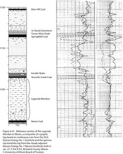
Continuous core from the ISGS #1 Elysium borehole, drilled in sec. 27, T 4 N, R 9 E, Richland County (API 12-159-25922-00). Core descriptions by D.M. Morse and W.J. Nelson are on file, along with electric and gamma-ray logs. In the core, the Lagonda Member occupies the depth interval from 1,185.0 to 1,237.9 ft (361.2 to 377.3 m) and is 52.9 ft (16.1 m) thick (Figure 4-41).
Reference author(s)
Present report.
Reference status
Logs of the Elysium borehole are on file at the ISGS Geological Records Unit and can be downloaded from the ISGS website. Core is available for study at the ISGS Geological Samples Library, but it presently lacks a call number.
Stratigraphic relationships
The Lagonda has been variously classified as a member or as a formation in Missouri; it is currently a formation (Gentile and Thompson 2004). The lower boundary has remained stable at the top of the Bevier Coal Bed, but various authors have shifted the upper boundary. As presently defined, the Lagonda extends to the base of the Breezy Hill Limestone Member, which is at the base of the overlying Mulky Formation (Gentile and Thompson 2004).
The Lagonda is hereby extended into the Illinois Basin at the rank of member. As used here, the Lagonda Member comprises siliciclastic strata between the top of the Bevier Coal Bed and the base of the Breezy Hill Limestone Member, where present. Where the Breezy Hill is absent, the Lagonda extends to the base of the Houchin Creek Coal or, where the coal is missing, to the base of the Excello Shale.
Extent and thickness
In Missouri, the Lagonda generally ranges from 35 to 95 ft (11 to 28 m) thick, except near the Lincoln fold (anticline) north of St. Louis, where it pinches out (Searight and Howe 1961; Gentile and Thompson 2004). No isopach maps of this interval in the Illinois Basin are known. A survey of unpublished cross sections and core data shows a thickness range from less than 10 ft (3 m) to about 90 ft (27 m) in the Fairfield Basin and central part of the Western Shelf. The greatest thickness was found in western Fayette County. The Lagonda thickness does not show an obvious relation to basin structure. Data from Edwards County, near the basin center, show a thickness of less than 20 ft (6 m), whereas in Macoupin County on the Western Shelf, the Lagonda varies from less than 20 to more than 60 ft (~6 to 18 m) thick. On most of the Sparta Shelf and west of the Illinois River, the Survant Coal is absent, the Survant and Houchin Creek underclays merge, and the Lagonda Member is absent. In western Kentucky, “the interval between the Survant and Houchin Creek coals is a 20- to 50-foot-thick (6 to 15 m) coarsening-upward sequence, except where the entire interval is composed of thick sandstone” (Greb et al. 1992, p. 45).
Lithology
In Missouri, the Lagonda consists of shale, siltstone, and sandstone and tends to coarsen upward, but in places, sandstone fills channels that truncate the Bevier Coal. This sandstone is part of the well-known “Squirrel sand” of drillers, so named because it appears to “jump around” in the section. Marine fossils have been reported in shale near the base (Searight and Howe 1961; Gentile and Thompson 2004).
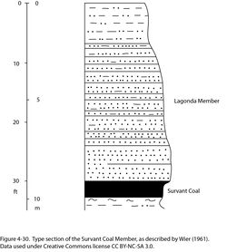
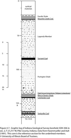
The lithology in Illinois is closely similar to that in Missouri. An upward-coarsening succession is prevalent. As shown by core data, shale at the base is dark gray to nearly black, silt-free to finely silty, and thinly fissile but not “slaty.” Siderite nodules are common. Silt content increases upward and siltstone or sandstone laminae appear. Planar, ripple, and cross lamination are present; some cores display well-developed tidal rhythmites. The upper part of the Lagonda may include siltstone and sandstone, which is laminated and burrowed. At the top, the rock grades to nonfissile claystone up to nearly 6.6 ft (2.0 m) thick, bearing slickensides, nodules, roots, and other features of a well-developed paleosol. Some logs indicate upward-fining sandstone that cuts down from the upper part of the Lagonda, filling valleys or channels. At their deepest, these valleys are incised 60 ft (18 m) below the Bevier Coal, cutting out the Colchester Coal. Examples of infilled valleys have been found in Effingham and Wabash Counties, as well as in the type (Figure 4-30) and reference section (Figure 4-7) for the Survant Coal Member. In northern Illinois, specifically a section near Lowell in LaSalle County, the lower part of the Lagonda consists of calcareous shale with nodules, lenses, and thin interbeds of limestone that yield marine fossils (Willman and Payne 1942; Smith et al. 1970; Trask 1987).
Core(s)
Photograph(s)
Contacts
Both contacts are normally sharp but conformable to slightly disconformable. Where sandstone occupies incised valleys, the lower contact is erosive.
Well log characteristics
Electric logs show the typical response for upward-coarsening or upward-fining valley-fill successions, or both. On gamma-ray logs, the basal Lagonda exhibits profiles typical for clay shale.
Fossils
Fossils are not common. A few core logs note Lingula, ostracods, and conchostracans(?) in dark shale near the base. Plant remains occur close to the contact with the Bevier Coal, and root traces are at the top of the Lagonda. Burrows and other trace fossils are common in sandy portions of the member. Planolites and Palaeophycus were identified in a core from White County. Marine fossils identified in shale and thin limestone from the lower Lagonda in LaSalle County include horn corals and the brachiopods Ambocoelia, Chonetes, Marginifera, Mesolobus, Neospirifer, and Squamularia.
Age and correlation
Microfossils have not been identified, and zonation has not been established. The Lagonda is best correlated with reference to the palynology of the bracketing coal units (Peppers 1996). In Iowa, the Lagonda interval is the upper part of the Swede Hollow Formation. The marine Red Haw Limestone Member (Pope 2012), which closely overlies the Bevier Coal, probably has its counterpart in thin marine limestone near the base of the Lagonda Member in LaSalle County, Illinois.
Environments of deposition
The Lagonda Member incorporates transgressive, highstand, and regressive deposits of an intermediate-level cyclothem. Basal dark shale, bearing marine to brackish fauna, records a rapid advance of the sea. The lower part of the member probably accumulated in relatively deep water, below the normal wave base. Upward coarsening reflects a gradually falling sea level and the progradation of deltas into the basin. Water was likely brackish and tidally influenced. Late in Lagonda time, the Illinois Basin became fully emergent, paleosols developed, and deep valleys were scoured. Not enough is known of lithofacies trends to identify sediment source areas or tectonic trends beyond identifying much of the Western Shelf as a positive area. Local abrupt changes in thickness of the Lagonda, not clearly related to the known structure, suggest that some areas of thick Lagonda reflect sites where the basin was incompletely filled during previous sedimentary cycles.
Economic importance
None.
Remarks
References
- Gentile, R.J., and T.L. Thompson, 2004, Paleozoic succession in Missouri, Part 5, Pennsylvanian Subsystem, Volume A, Morrowan strata through Cherokee Group: Missouri Geological Survey, Report of Investigations 70, 241 p. and correlation chart.
- Gordon, C.H., 1896, A report on the Bevier sheet, in C.R. Keyes, ed., Reports on areal geology, v. 9: Rolla, Missouri Geological Survey, 75 p.
- Greb, S.F., D.A. Williams, and A.D. Williamson, 1992, Geology and stratigraphy of the western Kentucky coal field: Kentucky Geological Survey, Series 11, Bulletin 2, 77 p., 1 pl.
- Hasenmueller, W.A., and C.H. Ault, 1991, Reference core and correlation of key beds in the Petersburg and Linton Formations (Pennsylvanian) in Indiana: Indiana Geological Survey, Occasional Paper No. 57, 8 p.
- Peppers, R.A., 1996, Palynological correlation of major Pennsylvanian (Middle and Upper Carboniferous) chronostratigraphic boundaries in the Illinois and other coal basins: Geological Society of America, Memoir 188, 111 p. and correlation chart.
- Pope, J.P., 2012, Description of Pennsylvanian units, revision of stratigraphic nomenclature, and reclassification of the Morrowan, Atokan, Desmoinesian, Missourian, and Virgilian stages in Iowa: Iowa Geological and Water Survey, Special Report Series No. 5, 140 p.
- Searight, W.V., and W.B. Howe, 1961, Pennsylvanian System, in W.B. Howe and J.W. Koenig, eds., The stratigraphic succession in Missouri: Missouri Geological Survey, v. 40, 2nd Series, p. 78–122.
- Smith, W.H., R.B. Nance, M.E. Hopkins, R.G. Johnson, and C.W. Shabica, eds., 1970, Depositional environments in parts of the Carbondale Formation—western and northern Illinois: Francis Creek Shale and associated strata and Mazon Creek biota: Illinois State Geological Survey, Guidebook Series No. 8, 125 p.
- Trask, C.B., 1987, Cyclothems in the Carbondale Formation (Pennsylvanian, Desmoinesian Series) of La Salle County, Illinois: Geological Society of America, Centennial Field Guide, Vol. 3, North-Central Section, p. 221–226.
- Wier, C.E. 1961, Stratigraphy of the Carbondale and McLeansboro Groups in southwestern Indiana: Indiana Geological Survey, unpublished bulletin, 147 p. and unnumbered appendix, http://hdl.handle.net/2022/3612 (accessed October 5, 2020).
- Willman, H.B., and J.N. Payne, 1942, Geology and mineral resources of the Marseilles, Ottawa, and Streator Quadrangles: Illinois State Geological Survey, Bulletin 66, 388 p., 29 pls.
ISGS Codes
| Stratigraphic Code | Geo Unit Designation |
|---|---|

