Houchin Creek Coal Member
Lithostratigraphy: Carbondale Formation >>Houchin Creek Coal Member
Chronostratigraphy: Paleozoic Erathem >>Pennsylvanian Subsystem >>Desmoinesian Series
Allostratigraphy: Absaroka Sequence
Primary source
Nelson, W.J., P.H. Heckel and J.M. Obrad, 2022, Pennsylvanian Subsystem in Illinois: Illinois State Geological Survey, Bulletin (in press).
Contributing author(s)
W.J. Nelson
Name
Original description
Fuller and Ashley (1902, p. 7) wrote, “The Houchin Creek coal, lying between the Petersburg [Springfield] and Survant beds, is exposed in the vicinity of Houchin Creek, Selvin, and Hemingway, as well as other places. Its thickness is variable, reaching in places 18 inches [45 cm], and it is almost invariably overlain by black, sheety, bituminous shale like that overlying the Petersburg coal.”
Derivation
The name refers to a small tributary of South Fork Patoka River in Pike County, Indiana. The origin of the creek’s name is unknown; most likely, it was a family name.
Other names
A variety of names were used before basin-wide continuity of this unit was recognized. These include Coal IVa (Indiana), No. 4 coal (Illinois), and the No. 8b or Ruff coal bed in western Kentucky. Wanless (1931) introduced the name Summum (No. 4) coal based on outcrops in Fulton County, Illinois. Kosanke et al. (1960) formalized the unit name as the Summum (No. 4) Coal Member (of Carbondale Formation). Jacobson et al. (1985) adopted the name Houchin Creek Coal Member throughout the Illinois Basin on the basis of priority.
History/background
See above.
Type section
Type location
Highwall on the north side of an abandoned strip mine (the Blackfoot Mine), SE¼ NE¼ SW¼ sec. 3, T 3 S, R 7 W, Pike County, Indiana. Previously unpublished, the section reads as follows:
| Feet | Meters | Lithology |
| 4.0 | 1.2 | Shale, light to medium gray, thin- to medium-bedded |
| 1.5 | 0.45 | Shale, dark gray to black, slightly calcareous, scattered crinoid columnals and small brachiopods, nodules and thin lenses of gray to tan, finely crystalline limestone |
| 0.9 | 0.27 | Shale, black, fissile |
| 1.2 | 0.36 | Hanover Limestone Member (Stendal Limestone of Wier), black, dense, argillaceous, few fossils (not named), contains lenses of dark gray to tan limestone that are fossiliferous. Unit is lenticular, varies from 0 to 2 ft thick. |
| 2.2 | 0.67 | Excello Shale Member, black, fissile, alternating hard and soft layers |
| 0.5 | 0.15 | Houchin Creek Coal Member, bright banded |
| 5.3 | 1.6 | Claystone, light gray, scattered rootlets |
| 4.0 | 1.2 | Shale, light gray, weathers brown, sandy |
| 1.2 | 0.36 | Sandstone, medium gray, silty, calcareous, single bed |
| 28.0 | 8.5 | Sandstone, light gray, fine grained, shaly, mostly thin- to medium-bedded, interlaminated gray sandy shale contains siderite bands. Base under water, close to top of Survant Coal Member, which was mined. Wier and Stanley (1952) report average Survant Coal thickness 2.4 ft at this mine. |
Total section 34.5 ft (10.5 m).
Type author(s)
Wier (1961, locality 6). This is an unpublished manuscript.
Type status
Unknown, but after more than half a century, the prognosis is poor.
Reference section(1)
Reference location
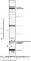
The principal reference section is core from Indiana Geological Survey borehole SDH-306, drilled in sec. 2, T 2 S, R 7 W, Pike County, Indiana (Figure 4-7).
Reference author(s)
Hasenmueller and Ault (1991) published the core description and gamma-ray and electric logs from SDH-306.
Reference status
Logs from SDH-306 are on file at the Indiana Geological Survey and can be downloaded from the Indiana Geological Survey website (well ID number 115871). Core is archived at the Indiana Geological Survey core facility in Bloomington under core file no. 609.
Reference section(2)
Reference location
As a reference section for Illinois, the type section of the Summum cyclothem (Wanless 1957, geologic section 39, p. 204–205) would have served well (Figure 4-43). Unfortunately, Peppers (1970, p. 50) reported that the section Wanless (1957) described had been “destroyed by strip mine operations.” Peppers (p. 50) nominated, but did not describe, an “alternate type section” along Big Creek in Fulton County, Illinois. Russell Jacobson and Brian Trask of the ISGS visited this site in 1980, describing and photographing the outcrop. At the time, the exposure showed about 4 ft (1.2 m) of black shale (Excello) overlying 3 to 4 ft (0.9 to 1.2 m) of coal, with the base concealed. Such a short section is not informative enough to serve as a reference section.
Nominated here as the principal reference section for Illinois is Freeman United Coal Mining Company borehole C-1-74 (Crown II Mine production shaft), located in sec. 23, T 12 N, R 6 W, Macoupin County (ISGS county no. 21495). The Houchin Creek Coal is 3.5 ft (107 cm) thick in the depth range of 359.4 to 362.9 ft (109.5 to 110.6 m; Figure 4-44).
Reference author(s)
Present report.
Reference status
Core is available at the ISGS Geological Samples Library (storage number C-10215). A core description is on file at the ISGS Geological Records Unit and is available on the ISGS website.
Stratigraphic relationships
The relationships of the Houchin Creek Coal are uncomplicated. The seam is not known to split or merge. It rests on well-developed underclay that is considered the top of the Lagonda Member (new in Illinois), except in small areas where the Breezy Hill Limestone Member occurs beneath the underclay. The black, slaty Excello Shale directly overlies the Houchin Creek nearly everywhere in the basin.
Extent and thickness
The Houchin Creek Coal extends nearly basin-wide. Small areas of erosion or nondeposition occur mainly on the Western Shelf. Some drill cores show the Excello Shale resting with a sharp contact on truncated underclay, indicating probable scouring of peat during marine transgression. The Houchin Creek is 2 ft (60 cm) or thinner across most of the Illinois Basin. Thicker coal is confined to small pods that are widely scattered geographically. Coal 4.0 ft (1.2 m) or thicker has been reported in Sullivan and Gibson Counties, Indiana (Harper 1988b; Eggert 1994), Grundy County, Illinois (Jacobson 1985), and several areas in northwestern Illinois, including an extreme thickness of 6 ft (1.8 m) near Soperville in Knox County (Smith and Berggren 1963). Areas of thick Houchin Creek Coal in northwestern Illinois seem to be associated with abandoned channels in the underlying Pleasantview Sandstone (Smith and Berggren 1963).
Lithology
With rare exceptions, the Houchin Creek is bright-banded coal that has well-developed cleat. It lacks persistent clastic layers. The coal has a moderate to high sulfur content; lenses, laminae, and cleat facings of pyrite are plentiful.
Core(s)
Photograph(s)
Contacts
Both contacts typically are sharp. The upper contact, to the Excello Shale, commonly is erosive. Numerous cores show the base of the Excello in direct contact with underclay.
Well log characteristics
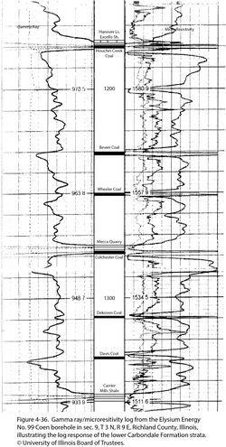
Typical for coal. Together with the overlying Excello Shale and Hanover Limestone, the Houchin Creek produces a distinctive double-peaked or “bird’s-beak” profile on resistivity logs (Figure 4-36).
Fossils
Peppers (1970) treated the spore flora of the Houchin Creek in detail, publishing a list of taxa that covers an entire page. In addition, coal balls have been collected from the Houchin Creek in northern Illinois, where they are locally abundant. Many of these consisted of large logs of lycopsids. The flora from these coal balls is dominated by lycopsids, particularly Diaphorodendron phillipsii, with smaller numbers of the cordaitalean gymnosperm, Pennsylvanioxylon birame. This is the youngest coal in the Illinois Basin that has a significant cordaitalean component (W.A. DiMichele, Smithsonian Institution, written communication, 2017).
Age and correlation
Peppers (1970) considered the spore assemblage of the Houchin Creek markedly different from that of the older Lowell (Survant) Coal but difficult to distinguish from that of the younger Springfield Coal. Peppers (1996) placed the Houchin Creek in spore assemblage zone CP, which extends from the Dekoven to the Springfield Coal. Given that the overlying Excello Shale is recognized in both the Midcontinent and Illinois Basins, the Houchin Creek is correlated with the Mulky Coal in the Midcontinent. An exact equivalent in the Appalachian Basin is not known. The Houchin Creek position probably falls between the Lower and Middle Kittanning coal beds in Ohio and Pennsylvania, the Princess No. 6 and No. 7 coal beds in eastern Kentucky, and slightly above the No. 6 Block coal bed in West Virginia (Peppers 1996).
Environments of deposition
The Houchin Creek/Mulky Coal represents a planar peat deposit of vast extent. Only a few areas on the Western Shelf were elevated sufficiently that peat did not accumulate or was not preserved. The absence of contemporaneous fluvial deposits and the rarity of gray shale clastic wedges (see next entry) place the setting low on the coastal plain.
Economic importance
Except in a few small areas, this coal is too thin to mine. It is seldom suited to multiseam surface operations because it is not close enough to other minable coal layers. Treworgy and Bargh (1982) estimated 514 million tons (466 million metric tons) as potentially minable by underground methods in Illinois.
Remarks
References
- Eggert, D.L., 1994, Coal resources of Gibson County, Indiana: Indiana Geological Survey, Special Report 50, 36 p. and 1 pl.
- Fuller, M.L. and G.H. Ashley, 1902, Ditney Folio, Indiana: U.S. Geological Survey, Geologic Atlas of the United States, Folio 84, 8 p., 7 pls., 1:125,000.
- Harper, D., 1988b, Coal mining in Sullivan County, Indiana: Indiana Geological Survey, Special Report 43, 48 p.
- Hasenmueller, W.A., and C.H. Ault, 1991, Reference core and correlation of key beds in the Petersburg and Linton Formations (Pennsylvanian) in Indiana: Indiana Geological Survey, Occasional Paper No. 57, 8 p.
- Jacobson, R.J., 1985, Coal resources of Grundy, La Salle, and Livingston Counties, Illinois: Illinois State Geological Survey, Circular 536, 58 p., 6 pls.
- Jacobson, R.J., C.B. Trask, C.H. Ault, D.D. Carr, H.H. Gray, W.A. Hasenmueller, D. Williams, and A.D. Williamson, 1985, Unifying nomenclature of the Pennsylvanian System in the Illinois Basin: Transactions of the Illinois Academy of Science, v. 78, no. 1–2, p. 1–11.
- Kosanke, R.M., J.A. Simon, H.R. Wanless, and H.B. Willman, 1960, Classification of the Pennsylvanian strata of Illinois: Illinois State Geological Survey, Report of Investigations 214, 84 p. and 1 pl.
- Peppers, R.A., 1970, Correlation and palynology of coals in the Carbondale and Spoon Formations (Pennsylvanian) of the northeastern part of the Illinois Basin: Illinois State Geological Survey, Bulletin 93, 173 p.
- Peppers, R.A., 1996, Palynological correlation of major Pennsylvanian (Middle and Upper Carboniferous) chronostratigraphic boundaries in the Illinois and other coal basins: Geological Society of America, Memoir 188, 111 p. and correlation chart.
- Smith, W.H., and D.J. Berggren, 1963, Strippable coal reserves of Illinois, Part 5A, Fulton, Henry, Knox, Peoria, Stark, Tazewell, and parts of Bureau, Marshall, Mercer, and Warren Counties: Illinois State Geological Survey, Circular 348, 59 p., 4 pls.
- Treworgy, C.G., and M.H. Bargh, 1982, Deep-minable coal resources of Illinois: Illinois State Geological Survey, Circular 527, 62 p., 2 pls.
- Wanless, H.R., 1931, Pennsylvanian cycles in western Illinois: Illinois State Geological Survey, Bulletin 60, p. 179–193.
- Wanless, H.R., 1957, Geology and mineral resources of the Beardstown, Glasford, Havana, and Vermont Quadrangles: Illinois State Geological Survey, Bulletin 82, 233 p.
- Wier, C.E. 1961, Stratigraphy of the Carbondale and McLeansboro Groups in southwestern Indiana: Indiana Geological Survey, unpublished bulletin, 147 p. and unnumbered appendix, http://hdl.handle.net/2022/3612 (accessed October 5, 2020).
ISGS Codes
| Stratigraphic Code | Geo Unit Designation |
|---|---|


