Historical:Springfield and Harrisburg Coal Members
Lithostratigraphy: Kewanee Group >>Carbondale Formation >>Springfield Coal Member
Chronostratigraphy: Paleozoic Erathem >>Pennsylvanian Subsystem >>Desmoinesian Series
Allostratigraphy: Absaroka Sequence
Authors
M. E. Hopkins and J. A. Simon
Name Origin
The Springfield (No. 5) Coal Member and the Harrisburg (No. 5) Coal Member of the Carbondale Formation are the same unit, but separate names are retained because of long-established usage-- "Springfield" in central, northern, and western Illinois and "Harrisburg" in southern and eastern Illinois. The term "No. 5" was first applied to this coal by Worthen (1870, p. 93) in his description of the geology of Fulton County. It was later applied to the coal mined in the Springfield, Sangamon County, district (Shaw and Savage, 1913, p. 3). The Harrisburg (No. 5) Coal Member (Shaw and Savage, 1912, p. 7) is named for Harrisburg, Saline County, where it is mined.
Type Section
Underground exposures in coal mines in Springfield were made the type section (16, 16N-4W) (Wanless, 1956, p. 10).
Correlation
The No. 5 Coal is the most important coal in Indiana, where it is now called the Springfield Coal Member (V), and in western Kentucky, where it is called the No. 9 (Mulford) coal. It is correlated with the Summit coal in Missouri.
Extent and Thickness
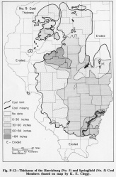
It is commonly 4-8 feet thick (fig P-12). The coal is absent along the northern margin of the Pennsylvanian rocks.
Description
The No. 5 Coal is second only to the Herrin (No. 6) Coal in commercial importance in Illinois. In southwestern Illinois it has been strip mined in a few pits where the Herrin is the principal coal. It is normally overlain by a black fissile shale, but in southeastern Illinois, in a belt several miles wide that trends southwestward, the coal is thick and it is overlain by the gray silty Dykersburg Shale. In that belt the coal is more commonly split by shale partings, and contains less pyrite than where it is overlain by the black fissile shale (Hopkins, 1968).
References
HOPKINS, M. E., 1968, Harrisburg (No. 5) Coal reserves of southeastern Illinois: Illinois State Geological Survey Circular 431, 25 p.
SHAW, E. W., and T. E. SAVAGE, 1912, Murphysboro and Herrin Quadrangles: USGS Geological Atlas Folio 185, 15 p.
SHAW, E. W., and T. E. SAVAGE, 1913, Tallula and Springfield Quadrangles: USGS Geological Atlas Folio 188, 12 p.
WANLESS, H. R., 1956, Classification of the Pennsylvanian rocks of Illinois as of 1956: Illinois State Geological Survey Circular 217, 14 p.
WORTHEN, A. H., 1870, Geology and paleontology: Geological Survey of Illinois, v. 4, 508 p.
ISGS Codes
| Stratigraphic Code | Geo Unit Designation |
|---|---|

