Historical:Fraileys Shale
Lithostratigraphy: Pope Megagroup >>Okaw Group >>Golconda Group >>Fraileys Shale
Chronostratigraphy: Paleozoic Erathem >>Mississippian Subsystem >>Chesterian Series >>Hombergian Stage
Allostratigraphy: Kaskaskia Sequence
Authors
Elwood Atherton, Charles Collinson, and Jerry A. Lineback
Name Origin
The Fraileys Shale (McFarlan et al., 1955, p. 18) is named for Fraileys Landing (abandoned), Hardin County, about a mile northeast of the type section.
Type Section
The type section of the Fraileys Shale is in a bluff along Haney Creek (NE NE SE 9, 12S-10E), where the formation is 94 feet thick.
Extent and Thickness
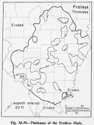
The Fraileys Shale is 80-100 feet thick in most of Williamson County, and it thins irregularly northward to 30-40 feet in the northern and northeastern areas (fig. M-39). Great variations in thickness within short distances have a reciprocal relation with units above and below.
Description
The Fraileys is dominantly shale, with minor amounts of limestone and, locally, sandstone. The Fraileys is dominantly dark gray shale. A bed of red shale a few feet below the top and a bed of siltstone just below the shale are persistent in the southern area. Limestone beds occur sporadically at numerous levels. A bed about 15 feet below the top is fairly persistent, but the others, mostly lenticular accumulations of fossil debris, thin rapidly and disappear within a short distance. Some of these beds contain abundant fragments of bright red, orange, and green fossils, mainly bryozoans but also a few oolites and other detrital grains. In the north, limestone is fairly abundant locally in the Fraileys, particularly in the lower part, and in places it is difficult to distinguish limestone at the base of the Fraileys from the underlying Beech Creek Limestone. Sandstone in the Fraileys, where present in significant amount, is assigned to the Big Clifty Sandstone Member.
Fossils
The corkscrew-like axes of the bryozoan Archimedes reach a peak in number of species and abundance of specimens in the Fraileys and Haney Formations. A brachiopod faunal zone, the "Camarophoria"--Stenoscisma explanata Range Zone, extends from the Fraileys upward to the top of the Chesterian strata. The Pterotocrinus capitalis Range Zone is equivalent to the lower half of the Fraileys Shale.
References
MCFARLAN, A. C., D. H. SWANN, F. H. WALKER, and EDMUND NOSOW, 1955, Some old Chester problems-Correlations of lower and middle Chester formations of western Kentucky: Kentucky Geological Survey Bulletin 16, 37 p.
ISGS Codes
| Stratigraphic Code | Geo Unit Designation |
|---|---|

