Chesterian Series
Lithostratigraphy: Pope Megagroup
Chronostratigraphy: Paleozoic Erathem >>Mississippian Subsystem >>Chesterian Series
Allostratigraphy: Kaskaskia Sequence
Primary source
Willman, H. B., Elwood Atherton, T. C. Buschbach, Charles Collinson, John C. Frye, M. E. Hopkins, Jerry A. Lineback, and Jack A. Simon, 1975, Handbook of Illinois Stratigraphy: Illinois State Geological Survey Bulletin 95, 261 p.
Contributing author(s)
Elwood Atherton, Charles Collinson, and Jerry A. Lineback
Name
Original description
Chesterian Series (Worthen, 1860, p. 312-313; Swann, 1963, p. 20).
Derivation
Named for Chester, Randolph County, where it is well exposed in the bluffs of the Mississippi River.
Other names
History/background
It was originally called the Kaskaskia Limestone (Hall, 1857) and the Archimedes Limestone (Swallow, 1858) before it was named the Chester Limestone. Later it was made the Chester Group, and since 1948 has been the Chesterian Series (J. M. Weller et al., 1948).
Type section
Type location
Type author(s)
Type status
Reference section
Reference location
Reference author(s)
Reference status
Stratigraphic relationships
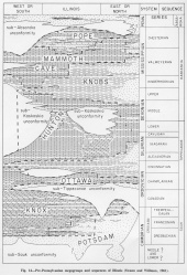
The Chesterian Series is the uppermost series of the Mississippian System. It extends from the major unconformity at the base of the Pennsylvanian System (sub-Absaroka unconformity) down to the base of the Shetlerville Member of the Renault Formation, which is the top of the Valmeyeran Series.
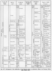
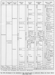
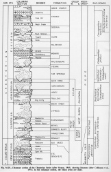
The Chesterian Series is subdivided into three stages, the Gasperian (below), Hombergian, and Elviran (Swann, 1963). These units were derived from the New Design, Homberg, and Elvira Groups, which had been used like provincial time-stratigraphic units (figs. M-27 and M-28). The series includes five groups, 20 formations, and 14 members, and it forms the major part of the Pope Megagroup (fig. 14).
Extent and thickness
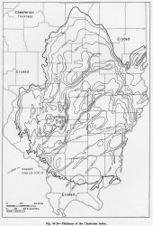
The Chesterian Series occupies much of the southern half of Illinois (fig. M-26). It is a little more than 1400 feet thick in Johnson County in the southern part of the Illinois Basin and thins outward to its truncated edge. The thickness pattern reflects sub-Pennsvlvanian valleys that generally run from norheast to southwest and cut into the Chesterian rocks. Chesterian strata crop out in western and southern Illinois from near Valmeyer south to Grand Tower and then eastward through Hardin County to the Ohio River.
On the thickness maps of the Chesterian Series, the eroded margins of the formations from Alton, Madison County, south and east to the Ohio River in Hardin County are largely at the present surface, but the margins trending northeast across the state from the Mississippi Valley are beneath Pennsylvanian strata.
Lithology
The Chesterian Series consists of limestone-shale formations alternating with sandstone-shale formations (fig. M-25). The Aux Vases Sandstone, long considered to be the base of the Chesterian, is excluded from the series because it is in the Platycrinites penicillus Zone near the top of the Valmeyeran Series (Swann, 1963).
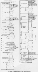
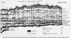
Many of the Chesterian formations have distinctive characters on electric logs (fig. M-29), but the sandstone bodies, although widely traceable, have great lenticularity (fig. M-30).
Core(s)
Photograph(s)
Contacts
Well log characteristics
Fossils
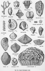
Many of the Chesterian limestones and shales are abundantly fossiliferous. The sandstones are much less fossiliferous, but contain some plant fossils. Coals, a few inches thick at most, occur in some of the Chesterian sandstones. Many of the limestones contain abundant crinoidal fragments, and the series is characterized by the presence of Talarocrinus, which distinguishes it from the underlying Valmeyeran containing Platycrinites penicillus. Blastoids and the corkscrew bryozoan, Archimedes, are common and characteristic (fig. M-4). Several conodont assemblage zones, shown in figure M-25, are useful in differentiating Chesterian rocks (Collinson et al., 1971).
Age and correlation
Environments of deposition
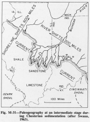
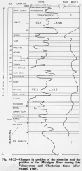
The clastic sediments in the Chesterian Series were transported by the ancient Michigan River from the northeast and were deposited in deltaic bodies in the marine embayment in the Illinois Basin (Potter, 1962a; Swann, 1963, 1964). The alternation of limestone and sandstone formations resulted from lateral shifts in the mouth of the river and in the position of the shoreline (fig. M-31) during the progressive sinking of the basin (fig. M-32).
Economic importance
Remarks
References
COLLINSON, CHARLES, C. B. REXROAD, and T. L. THOMPSON, 1971, Conodont zonation of the North American Mississippian: Geological Society of America Memoir 127, p. 353-395; Illinois State Geological Survey Reprint 1972-A.
HALL, JAMES, 1857, Observations upon the Carboniferous limestones of the Mississippi Valley (abstract): American Journal of Science, v. 23, p. 187-203.
POTTER, P. E., 1962a, Late Mississippian sandstones of Illinois: Illinois State Geological Survey Circular 340, 36 p.
SWALLOW, G. C., 1858, Explanations of the geological map of Missouri and a section of its rocks: American Association for the Advancement of Science Proceedings 11, part 2, p. 1-21.
SWANN, D. H., 1963, Classification of Genevievian and Chesterian (Late Mississippian) rocks of Illinois: Illinois State Geological Survey Report of Investigations 216, 91 p.
SWANN, D. H., 1964, Late Mississippian rhythmic sediments of Mississippi Valley: American Association of Petroleum Geologists Bulletin, v. 48, p. 637-658; Illinois State Geological Survey Reprint 1964-G.
WELLER, J. M., et al., 1948, Correlation of the Mississippian formations of North America: Geological Society of America Bulletin, v. 59, p. 91-196.
WORTHEN, A. H., 1860, Remarks on the discovery of a terrestrial flora in the Mountain Limestone of Illinois [abs.]: American Association for the Advancement of Science Proceedings, v. 13, p. 312-313.
ISGS Codes
| Stratigraphic Code | Geo Unit Designation |
|---|---|
