Grand Detour Formation
Lithostratigraphy: Ottawa Limestone Megagroup >>Platteville Group >>Plattin Subgroup >>Grand Detour Formation
Chronostratigraphy: Paleozoic Erathem >>Ordovician System >>Champlainian Series >>Blackriveran Stage
Allostratigraphy: Tippecanoe Sequence
Primary source
Willman, H. B., Elwood Atherton, T. C. Buschbach, Charles Collinson, John C. Frye, M. E. Hopkins, Jerry A. Lineback, and Jack A. Simon, 1975, Handbook of Illinois Stratigraphy: Illinois State Geological Survey Bulletin 95, 261 p.
Contributing author(s)
H. B. Willman and T. C. Buschbach
Name
Original description
Grand Detour Formation (Templeton and Willman, 1963, p. 83).
Derivation
Named for Grand Detour, Ogle County, which is 3 miles east of the type section.
Other names
History/background
Type section
Type location
The type section of the Grand Detour formation is located in a quarry in the west bluff of the Rock River, on the Walgreen estate 2 miles north of Dixon (NE 20, 22N-9E), where it is 52.3 feet thick.
Type author(s)
Type status
Reference section
Reference location
Reference author(s)
Reference status
Stratigraphic relationships
Extent and thickness
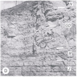
The Grand Detour Formation extends throughout most of Illinois, overlying the Mifflin Formation, underlying the Nachusa Formation, and conformable with both. It is generally about 50 feet thick in the northern outcrop area and in exposures in Calhoun County (fig. O-2D), but it thickens southward in subsurface to about 210 feet in southern Illinois. That it thickens rapidly south of Randolph County is suggested by the near-by exposures in Missouri.
Lithology
The Grand Detour consists largely of dolomite-mottled, lithographic, slightly argillaceous to pure limestone that contains thin beds of calcarenite; in places it is fine- to medium-grained dolomite. Most of it is medium bedded, with thin, brown-red, dark gray, or black shale partings, but it contains persistent units that are thick bedded to massive, fucoidal, and pure. The Dement Member (at the base) is pure; the Walgreen is argillaceous or shaly; the Stillman is pure, fucoidal, and massive; the Clement is calcarenite; the Hely is argillaceous; the Victory is pure and white or very light gray; and the Forreston (at the top) has alternating pure and argillaceous beds with red-brown shaly partings. Scour and corrosion surfaces occur between and within some of the members. The medium bedding and the dark, generally red-brown, shale partings distinguish the Grand Detour from the Mifflin below with its thin beds and green shale partings, and from the Nachusa above, which is purer, more uniform, and thick bedded to massive.
Core(s)
Photograph(s)
Contacts
Well log characteristics
Fossils
The Grand Detour is generally fossiliferous, having a varied brachiopod-molluscan fauna and several species of corals, among which Lambeophyllum and Tetradium are particularly common.
Age and correlation
The Grand Detour is the upper part of the McGregor Limestone north of Illinois and is equivalent to strata in the upper part of the Camp Nelson Formation, the Oregon Formation, and the lower part of the lower member of the Tyrone Formation in Kentucky, the upper part of the Lebanon Formation in Tennessee, and the upper part of the Lowville Limestone in New York.
Environments of deposition
Economic importance
Remarks
References
TEMPLETON, J. S., and H. B. WILLMAN, 1963, Champlainian Series (Middle Ordovician) in Illinois: Illinois State Geological Survey Bulletin 89, 260 p.
ISGS Codes
| Stratigraphic Code | Geo Unit Designation |
|---|---|
