Platteville Group
Lithostratigraphy: Ottawa Limestone Megagroup >>Platteville Group
Chronostratigraphy: Paleozoic Erathem >>Ordovician System >>Champlainian Series >>Blackriveran Stage
Allostratigraphy: Tippecanoe Sequence
Primary source
Willman, H. B., Elwood Atherton, T. C. Buschbach, Charles Collinson, John C. Frye, M. E. Hopkins, Jerry A. Lineback, and Jack A. Simon, 1975, Handbook of Illinois Stratigraphy: Illinois State Geological Survey Bulletin 95, 261 p.
Contributing author(s)
H. B. Willman and T. C. Buschbach
Name
Original description
Platteville Group (Bain, 1905, p. 18-21; Calvin, 1906, p. 60-61; Templeton and Willman, 1963, p. 63).
Derivation
Named for Platteville, Wisconsin, which is 4 miles east of the type exposures.
Other names
History/background
Type section
Type location
The type section of the Platteville Group is located along the Little Platte River. For a specific type section, Kay (1931 , p. 369, 371) designated a ravine exposure (SW NW NW 20, 3N-1W, Grant County, Wisconsin), but Templeton and Willman (1963) suggested as an alternate a more accessible roadcut 5 miles southwest of Platteville (SE SW SE 1, 2N-2W), where the group is 53.6 feet thick.
Type author(s)
Type status
Reference section
Reference location
Reference author(s)
Reference status
Stratigraphic relationships
In the type region, the Platteville Group includes the dominantly limestone formations that overlie the Glenwood Formation of the Anceli Group and underlie the Spechts Ferry or Guttenberg Formations of the Galena Group. In an east-west area through central Illinois it overlies the St. Peter Sandstone, and south of there it overlies the Joachim Dolomite.
Extent and thickness
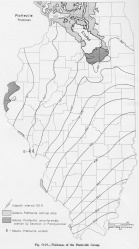
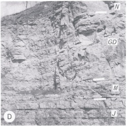
The Platteville Group is widely exposed in northern Illinois- in the Rock and Pecatonica Valleys above Dixon, in a small area near Galena in Jo Daviess County, and near Ottawa and La Salle in La Salle County (fig. O-19). The southern outcrop area, largely in Missouri on the east flank of the Ozark Dome, extends from Cape Girardeau north to St. Louis and, beyond a short covered interval, to exposures on the Lincoln Anticline. In Illinois the Platteville crops out at West Point Landing in Calhoun County (fig. O-2D). The group is only about 30 feet thick in extreme western Illinois, but it thickens to 135 feet in the Dixon outcrop area and southward to over 600 feet in subsurface in the extreme southern part of the state.
Lithology
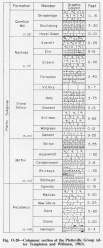
In northern Illinois the Platteville Group is largely blue-gray, lithographic, partly dolomite-mottled limestone, but in some areas, such as that near Dixon, it is gray, very fine-grained, cherty dolomite. In southern Illinois it is largely brown, lithographic, partly dolomite-mottled, slightly shaly limestone. It is subdivided (fig. O-20) into the Plattin Subgroup (above) which is dominated by the typical limestone facies, and the Pecatonica Formation, a persistent dolomite except where it grades to limestone in southern Illinois. The units are separated by a widespread corrosion surface, probably a diastem. The Plattin Subgroup is subdivided into the Mifflin (at the base). Grand Detour, Nachusa, and Quimbys Mill Formations on the basis of differences in purity, bedding, and texture. The Platteville formations and members have great lateral continuity and many of them are recognized in samples from borings (Buschbach, 1964).
Core(s)
Photograph(s)
Contacts
Well log characteristics
Fossils
The Platteville Group is generally fossiliferous, containing a large and varied fauna.
Age and correlation
The Platteville Group is equivalent to the Lowville and Chaumont Formations of the Black River Group in New York, the upper part of the Stones River Group in Tennessee, the upper part of the High Bridge Group in Kentucky, and the Black River Limestone in Indiana and Michigan. The Platteville Group was incorrectly correlated in early reports with the Trenton Limestone of New York.
Environments of deposition
Economic importance
Remarks
References
BAIN, H. F., 1905, Zinc and lead deposits of northwestern Illinois: USGS Bulletin 246, 56 p.
BUSCHBACH, T. C., 1964, Cambrian and Ordovician strata of northeastern Illinois: Illinois State Geological Survey Report of Investigations 218, 90 p.
CALVIN, SAMUEL, 1906, Geology of Winneshiek County: Iowa Geological Survey, v. 16, p. 37-146.
KAY, MARSHALL, 1931, Stratigraphy of the Ordovician Hounsfield Metabentonite: Journal of Geology, v. 39, p.
TEMPLETON, J. S., and H. B. WILLMAN, 1963, Champlainian Series (Middle Ordovician) in Illinois: Illinois State Geological Survey Bulletin 89, 260 p.
ISGS Codes
| Stratigraphic Code | Geo Unit Designation |
|---|---|


