Antioch Limestone Member
Lithostratigraphy: Carbondale Formation >>Antioch Limestone Member
Chronostratigraphy: Paleozoic Erathem >>Pennsylvanian Subsystem >>Desmoinesian Series
Allostratigraphy: Absaroka Sequence
Primary source
Nelson, W.J., P.H. Heckel and J.M. Obrad, 2022, Pennsylvanian Subsystem in Illinois: Illinois State Geological Survey, Bulletin (in press).
Contributing author(s)
W.J. Nelson
Name
Original description
Wier (1951) referred to “partly brecciated limestone” beneath Coal Va as the “Upper Alum Cave.” Wier (1961) proposed the name Antioch Limestone Member in an unpublished manuscript. The earliest published usage is in Shaver et al. (1970, p. 5).
Derivation
The name refers to the Antioch Church, near the type locality.
Other names
Kottlowski (1954) informally called this unit the Upper Alum Cave limestone.
History/background
None.
Type section
Type location
The type locality is an abandoned strip mine in the NE¼ SE¼ NW¼ of sec. 24, T 8 N, R 8 W, Sullivan County, Indiana, in the northeast corner of the Dugger 7.5' quadrangle.
Type author(s)
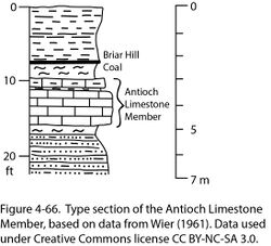
Wier (1961). The section (Figure 4-66) leaves much to be desired because it does not position the Antioch relative to older and younger named members aside from the thin coal above the limestone, which Shaver et al. (1970) identified as Bucktown (Briar Hill).
Type status
Current satellite imagery shows that the mine site has been reclaimed and no rock exposures remain.
Reference section
None.
Stratigraphic relationships
The Antioch occurs 1 to 7 ft (0.3 to 2.1 m) below the Briar Hill Coal. Separating the two members is siltstone, sandy shale, or mudstone. Burrowed mudstone occurs widely at this position in western Kentucky (David A. Williams, Kentucky Geological Survey, written communication, 2017).
Extent and thickness
The limestone occurs sporadically in west-central Indiana between Knox County on the south and Vermillion County on the north, and possibly farther south in Pike County (Shaver et al. 1986). The maximum thickness is 6.4 ft (195 cm) at the type locality. The only known occurrence in Illinois is based on drillers’ logs of coal-test borings in Saline County (Denny et al. 2007).
Lithology
Wier (1952) described this as “argillaceous brecciated limestone.” Kottlowski (1954) added “persistent, gray-buff, partly brecciated limestone bed, 2 to 6 feet [0.6 to 1.8 m] thick. . .. Locally, the lower part of the limestone consists of brecciated limestone fragments in a bluish-gray shale matrix.”
Core(s)
Photograph(s)
Contacts
Descriptions are not explicit. The contacts probably are sharp to rapidly gradational.
Well log characteristics
No logs that show this unit have been identified.
Fossils
Wier (1961, p. 80) wrote, “In most outcrops one can find a few remains of gastropods, ostracodes, brachiopods, and crinoid columnals.”
Age and correlation
Correlations into the Western Interior Basin are uncertain. The thin Alvis Coal Bed occurs in western Missouri and eastern Kansas between the Summit (Springfield) and Lexington (Herrin) Coals. At the Alvis stratotype, a quarry in western Missouri, marine limestone (Higginsville) both underlies and overlies the Alvis Coal and its underclay (Gentile and Thompson 2004). Heckel (1999, p. 86–89) placed the Higginsville Limestone beneath the Alvis Coal and its underclay near the top of the Upper Fort Scott cyclothem. Heckel (2013) positioned the Higginsville below the Alvis Coal and the Wimer School Limestone above the Alvis. If the Alvis Coal equals the Briar Hill, then the Antioch Limestone equals the Higginsville, and the younger Percy Limestone Member equals the Wimer School.
Environments of deposition
Although information is meager, the Antioch evidently represents a heretofore unrecognized, local or limited marine incursion into the Illinois Basin. This is possibly a “delta-top limestone” that formed in very shallow water on top of an abandoned delta lobe. The brecciated structure suggests subaerial exposure.
Economic importance
None.
Remarks
References
- Denny, F.B., R.J. Jacobson, and W.J. Nelson, 2007, Bedrock geology of the Harrisburg Quadrangle, Saline County, Illinois: Illinois State Geological Survey, Illinois Preliminary Geologic Map IPGM-Harrisburg-BG, 2 sheets, 1:24,000, and 11-page pamphlet.
- Gentile, R.J., and T.L. Thompson, 2004, Paleozoic succession in Missouri, Part 5, Pennsylvanian Subsystem, Volume A, Morrowan strata through Cherokee Group: Missouri Geological Survey, Report of Investigations 70, 241 p. and correlation chart.
- Heckel, P.H., 1999, Middle and Upper Pennsylvanian (Upper Carboniferous) cyclothem succession in Midcontinent Basin, U.S.A.: Kansas Geological Survey, Open-File Report 99-27, 236 p.
- Heckel, P.H., 2013, Pennsylvanian stratigraphy of Northern Midcontinent Shelf and biostratigraphic correlation of cyclothems: Stratigraphy, v. 10, nos. 1–2, p. 3–39.
- Kottlowski, F.E., 1954, Geology and coal deposits of the Dugger Quadrangle, Sullivan County, Indiana: U.S. Geological Survey, Coal Investigations Map C-11, 1 sheet, 1:24,000.
- Shaver, R.H., Ann M. Burger, G.R. Gates, H.H. Gray, H.C. Hutchison, S.J. Keller, J.B. Patton, C.B. Rexroad, N.M. Smith, W.J. Wayne, and C.E. Wier, 1970, Compendium of rock-unit stratigraphy in Indiana: Indiana Geological Survey, Bulletin 43, 229 p., 1 pl.
- Shaver, R.H., C. H. Ault, A.M. Burger, D.D. Carr, J.B. Droste, D.L. Eggert, H.H. Gray, D. Harper, N.R. Hasenmueller, W.A. Hasenmueller, A.S. Horowitz, H.C. Hutchison, B. Keith, S.J. Keller, J.B. Patton, C.B. Rexroad, and C.E. Wier, 1986, Compendium of Paleozoic rock-unit stratigraphy in Indiana—A revision: Indiana Geological Survey, Bulletin 59, 203 p.
- Wier, C.E., 1951, Geology and coal deposits of the Linton Quadrangle, Greene and Sullivan Counties, Indiana: U.S. Geological Survey, Coal Investigations Map C9, 1 sheet, 1:24,000.
- Wier, C.E., 1952, Distribution, structure, and mined areas of coals in Sullivan County, Indiana: Indiana Geological Survey, Preliminary Coal Map No. 2, 1 sheet, 1:126,720.
- Wier, C.E. 1961, Stratigraphy of the Carbondale and McLeansboro Groups in southwestern Indiana: Indiana Geological Survey, unpublished bulletin, 147 p. and unnumbered appendix, http://hdl.handle.net/2022/3612 (accessed October 5, 2020).
ISGS Codes
| Stratigraphic Code | Geo Unit Designation |
|---|---|
