Ste. Genevieve Limestone
Lithostratigraphy: Mammoth Cave Limestone Megagroup >>Ste. Genevieve Limestone
Chronostratigraphy: Paleozoic Erathem >>Mississippian Subsystem >>Valmeyeran Series >>Genevievian Stage
Allostratigraphy: Kaskaskia Sequence
Primary source
Willman, H. B., Elwood Atherton, T. C. Buschbach, Charles Collinson, John C. Frye, M. E. Hopkins, Jerry A. Lineback, and Jack A. Simon, 1975, Handbook of Illinois Stratigraphy: Illinois State Geological Survey Bulletin 95, 261 p.
Contributing author(s)
Elwood Atherton, Charles Collinson, and Jerry A. Lineback
Name
Original description
Ste. Genevieve Limestone (Shumard, 1860, p. 406).
Derivation
Named for Ste. Genevieve, Missouri, where it is about 100 feet.
Other names
History/background
Type section
Type location
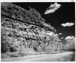
The type section of the Ste. Genevieve Limestone consists of outcrops in the bluffs along the Mississippi River 1-4 miles southeast of Ste. Genevieve.
Type author(s)
Type status
Reference section
Reference location
Reference author(s)
Reference status
Stratigraphic relationships
The Ste. Genevieve overlies the St. Louis Limestone and underlies the Aux Vases Sandstone throughout much of the southern half of the Illinois Basin. The contact is placed below the lowest prominent oolitic bed. Near its western border the Ste. Genevieve has a conglomeratic bed at its base and rests unconformably on the eroded top of the St. Louis Limestone. Elsewhere the two formations appear to be conformable and, in the transition zone, beds with Ste. Genevieve lithology intertongue with beds with St. Louis lithology. The contact between the Ste. Genevieve and the overlying Aux Vases Sandstone is conformable, but it is marked by a series of downward steps to the west as the upper limestone beds grade westward into sandstone.
Extent and thickness
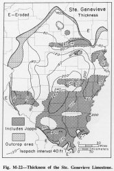
The Ste. Genevieve crops out from the vicinity of Alton, Madison County (fig. M-1B), south along the Mississippi Valley to Randolph County and from Union County, where it is about 300 feet thick, eastward across southern Illinois to Hardin County, where it averages about 250 feet thick (fig. M-22). The Ste. Genevieve Formation extends into eastern Missouri, southwestern Indiana, and western Kentucky.
Lithology
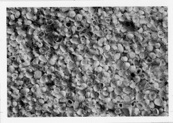
The Ste. Genevieve is generally light gray, but some beds of oolite (fig. M-1E) are nearly white. Chert is common and is generally gray, but in some places it is black. Thin beds of sandstone and sandy limestone, some traceable for many miles, occur mainly in the upper half of the formation. The sandstone is generally calcareous, light greenish gray, and very fine grained. A little shale, mainly dark greenish gray but locally red, purple, or green, occurs in the upper part of the formation. The Ste. Genevieve is subdivided into four members: the Fredonia Limestone Member at the base, the Spar Mountain Sandstone Member, the Karnak Limestone Member, and the Joppa Member (sandstone, limestone, dolomite, and shale).
Core(s)
Photograph(s)
Contacts
Well log characteristics
Fossils
Weathered surfaces of the Ste. Genevieve generally show abundant fossils, mainly crinoid fragments. Platycrinites ("Platycrinus") penicillus and Pugnoides ottumwa are characteristic, although they occur rarely in older or younger strata. The Ste. Genevieve is in the lower part of the Gnathodus bilineatus -- Cavusgnathus charactus Zone (Collinson et al., 1971).
Age and correlation
The Pella beds of Iowa are correlated with the Ste. Genevieve.
Environments of deposition
Economic importance
“Ohara” is an informal name applied to producing zones in the Karnak Limestone Member of the Ste. Genevieve Limestone.
“Spar Mountain” or “Rosiclare” are informal names applied to producing zones in the Spar Mountain Sandstone Member of the Ste. Genevieve Limestone.
“McClosky”, “Oblong” and “lower McClosky” are informal names applied to producing zones in the Fredonia Limestone Member of the Ste. Genevieve Limestone.
Remarks
References
COLLINSON, CHARLES, C. B. REXROAD, and T. L. THOMPSON, 1971, Conodont zonation of the North American Mississippian: Geological Society of America Memoir 127, p. 353-395; Illinois State Geological Survey Reprint 1972-A.
SHUMARD, B. F., 1860, Observations on the geology of the County of Ste. Genevieve: St. Louis Academy of Science Transactions, v. 1, p. 404-415.
ISGS Codes
| Stratigraphic Code | Geo Unit Designation |
|---|---|


