Menard Limestone
Lithostratigraphy: Pope Megagroup >>Menard Limestone
Chronostratigraphy: Paleozoic Erathem >>Mississippian Subsystem >>Chesterian Series >>Elviran Stage
Allostratigraphy: Kaskaskia Sequence
Primary source
Willman, H. B., Elwood Atherton, T. C. Buschbach, Charles Collinson, John C. Frye, M. E. Hopkins, Jerry A. Lineback, and Jack A. Simon, 1975, Handbook of Illinois Stratigraphy: Illinois State Geological Survey Bulletin 95, 261 p.
Contributing author(s)
Elwood Atherton, Charles Collinson, and Jerry A. Lineback
Name
Original description
Menard Limestone (S. Weller, 1913, p. 120, 128).
Derivation
Named for Menard, Randolph County.
Other names
History/background
Type section
Type location
The type section of the Menard Limestone is near Menard, Randolph County in the quarry at the Menard State Hospital (NE 23, 7S-7W). The formation is also well exposed in the Mississippi River bluffs at Menard and from Chester to Rockwood, Randolph County.
Type author(s)
Type status
Reference section
Reference location
Reference author(s)
Reference status
Stratigraphic relationships
Extent and thickness
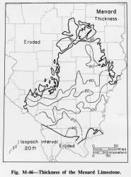
It is a limestone-shale formation, generally 100-150 feet thick in the southern area, 80-100 feet in the central part, and 45-60 feet in the northern and northwestern area, beyond which it is truncated by pre-Pennsylvanian erosion (fig. M-46).
Lithology
The Menard is readily divisible into three limestone members- the Walche, the Scottsburg, and the Allard- which are separated by unnamed shale members; a third shale occurs at the top. The limestone of the Menard is argillaceous, dark brownish gray to brown and buff, dense, and fine grained to lithographic. Some beds are oolitic, and many beds contain fine to coarse, dark, rounded grains that give the rock a characteristic speckled aspect. The limestone members are more or less shaly, and they include beds of shale as thick as 5 feet. Chert is present in some places. The shale of the Menard Formation is calcareous, dark gray, and fossiliferous, and it contains thin beds and nodules of limestone. The shale between the Walche and Scottsburg Limestone Members is 3-10 feet thick in most of the area underlain by the Walche Member, beyond which it is not recognized. It thickens in the northeast to about 20 feet or more in Wabash County. The shale between the Scottsburg and Allard Limestone Members is 30-40 feet thick in the far south and thins to about 5 feet in the north. Beds of green shale and green dolomite occur in this unit, and in the south a limestone about 10 feet thick is present in the lower half. The shale at the top of the Menard is generally 20-30 feet thick in the southern part of its extent and 10-20 feet in the northern part. It includes, at the top, a bed of limestone about 5 feet thick. This bed is persistent south of about T6S, but it is generally very thin or absent farther north. Locally, especially in the north, the erosional surface at the base of the Palestine cuts into the shale and in places entirely through it.
Core(s)
Photograph(s)
Contacts
Well log characteristics
Fossils
The initial appearance of Spirifer increbescens and Composita subquadrata is in the Menard (S. Weller, 1920). The pelecypod Sulcatopinna missouriensis is very abundant in places. The Pentremites fohsi Range Zone occurs in the lower part of the Menard (S. Weller, 1926).
Age and correlation
Environments of deposition
Economic importance
Remarks
References
WELLER, STUART, 1913, Stratigraphy of the Chester Group in southwestern Illinois: Illinois Academy of Science Transactions, v. 6, p. 118-129.
WELLER, STUART, 1920, Chester Series in Illinois: Journal of Geology, v. 28, p. 281-303, 395-416.
WELLER, STUART, 1926, Faunal zones in the standard Mississippian section: Journal of Geology, v. 34, p. 320-335.
ISGS Codes
| Stratigraphic Code | Geo Unit Designation |
|---|---|
