Mecca Quarry Shale Member
Lithostratigraphy: Carbondale Formation >>Mecca Quarry Shale Member
Chronostratigraphy: Paleozoic Erathem >>Pennsylvanian Subsystem >>Desmoinesian Series
Allostratigraphy: Absaroka Sequence
Primary source
Nelson, W.J., P.H. Heckel and J.M. Obrad, 2022, Pennsylvanian Subsystem in Illinois: Illinois State Geological Survey, Bulletin (in press).
Contributing author(s)
W.J. Nelson
Name
Original description
The Mecca Quarry is one of two units that Zangerl and Richardson (1963) treated exhaustively in their monograph on the paleoecology of Pennsylvanian black shales. The other unit was the Logan Quarry Shale, which is now called the Carrier Mills Shale Member (Tradewater Formation).
Derivation
The first part of the name refers to the nearby town of Mecca in Vermillion County, Indiana. The “quarry” was not a commercial stone operation but a pit that the authors opened to study the shale and collect its fossils.
Why the town came to be named Mecca is not clear. Deutsch (2009, p. 167) suggested that names such as Morocco and Mecca, Indiana, and Mahomet, Illinois, “should be seen as part of the broader flowering of romantic Orientalism in America’s heartland during the second half of the nineteenth century. Residents of Morocco and Mecca were attracted to these names for the same reasons that they joined the Ancient Order of the Nobles of the Mystic Shrine, visited the simulated streets of Cairo at the Chicago world’s fair of 1893, and smoked cigarette brands such as Camel, Mecca, and Medina.”
Other names
The ISGS has always referred to this unit as Mecca Quarry. For a time, the Indiana Geological Survey shortened the name to Mecca Shale Member. Shaver et al. (1986) attributed the name change to a 1965 manuscript by Charles E. Wier, no copies of which are known to exist. It is likely that Wier sought to use an established place name in preference to the “quarry,” which lacks geographic standing. Noting that the name Mecca Formation was previously applied to a Miocene unit in California, Hasenmueller and Ault (1991) reinstated the full name, Mecca Quarry Shale.
History/background
See above.
Type section
Type location
The type section is in the sides of gullies in the SW¼ NE¼ sec. 29, T 15 N, R 8 W, Parke County, Indiana.
Type author(s)
Zangerl and Richardson (1963, p. 44–47).
Type status
The present condition of these outcrops is unknown. Zangerl and Richardson (1963) described numerous additional sections that show the member.
Reference section
Reference location
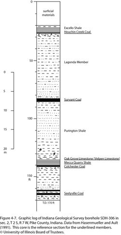
Core from Indiana Geological Survey drill hole SDH-306 is the reference for the Mecca Quarry Shale and several other named members. The hole was drilled east of Winslow in sec. 2, T 2 S, R 7 W, Pike County, Indiana. In this core, the Mecca Quarry is 3.8 ft (1.16 m) thick at a depth of 136.8 to 140.6 ft (41.7 to 42.9 m; Figure 4-7).
Reference author(s)
Hasenmueller and Ault (1991).
Reference status
In addition to the core description, gamma-ray and resistivity logs for SDH-306 are on file at the Indiana Geological Survey and can be downloaded from the IGS website. The hole ID number is 115871. Core from SHD-306 is catalogued under call number 609 at the Survey’s core facility in Bloomington, Indiana.
Stratigraphic relationships
The Mecca Quarry overlies the Francis Creek Shale and directly overlies the Colchester Coal where the Francis Creek is absent.
Extent and thickness
The Mecca Quarry occurs throughout the Illinois Basin. Where it lies directly above or close to the Colchester Coal, the Mecca Quarry Shale is generally 1 to 6 ft (30 to 180 cm) thick. The Mecca Quarry pinches out where the Francis Creek Shale is thick. It is generally absent where the gray shale is 30 ft (9 m) or thicker; the maximum thickness of Francis Creek having Mecca Quarry above is 39 ft (12 m; Smith 1970).
Lithology
The Mecca Quarry could be a “type example” of Pennsylvanian black shale. On the outcrop, the shale is “slaty” or “sheety,” splitting into very thin laminae that are of uniform thickness and slightly flexible. The shale exhibits widely spaced vertical joints that outline rectangular, rhombic, or diamond-shaped blocks. Calcareous concretions, in the shape of flattened spheroids, can be as thick as 2 ft (0.6 m) and as long as 8 ft (2.4 m). Much smaller gray calcareous concretions lend a pimply appearance to bedding surfaces. In some areas, large masses of black, argillaceous limestone occur at the base of the member. These contain goniatites, pelecypods, and fish remains. A thin basal “transgression shell breccia,” found in many other black shale units, comprises a “hash” of brachiopod and mollusk shell fragments.
Core(s)
Photograph(s)
Contacts
The lower contact typically is sharp and in some areas is erosive. In northern Illinois where the Colchester Coal was mined, the coal commonly was thinner under Mecca Quarry than Francis Creek Shale, suggesting partial erosion of the peat prior to black shale deposition. At the Cherry Mine in LaSalle County, “The black shale is present in rather long, thin pencils, forms lenses and commonly cuts out about a foot [30 cm] of coal where the lens starts” (Cady 1915, p. 69). The coal also thinned where black shale formed the immediate roof in an underground mine at Bloomington, Illinois (G.H. Cady, field notes, ISGS Library). The contact to overlying dark gray shale of the Oak Grove Member is generally gradational.
Well log characteristics
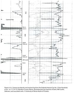
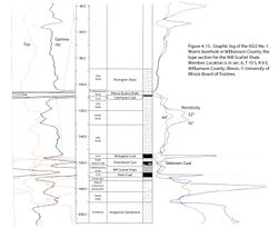
The Mecca Quarry produces extremely “hot” readings on gamma-ray logs and a distinctive leftward (low) inflection on resistivity logs (Figures 4-14 and 4-15).
Fossils
Zangerl and Richardson (1963) covered in detail the fossils of the Mecca Quarry Shale, their mode of preservation, and their paleoecology. The most common forms are linguloid and orbiculoid brachiopods; nautiloid and goniatite cephalopods; the bivalves Myalina, Dunbarella, and Pteria; conodonts; and the remains of sharks and bony fishes. Unidentified plant stems and “sticks” also are common. The basal shell breccia contains articulate brachiopods, gastropods, and bryozoans. Rexroad et al. (2001) described the conodont fauna of this unit.
Age and correlation
The Mecca Quarry is directly equivalent to the upper portion of the Oakley Shale Member of Iowa (Ravn et al. 1984) and Missouri (Gentile and Thompson 2004). As discussed above, the Oakley contains equivalents of both the gray Francis Creek Shale and the black Mecca Quarry. The unnamed black, fissile shale that overlies the Croweburg Coal or the Francis Creek equivalent in Kansas and Oklahoma is also a Mecca Quarry correlative. W.J. Nelson advocates extending the names “Francis Creek Shale” and “Mecca Quarry Shale” throughout the Midcontinent Basin, in the same fashion as the Excello and Anna Shales have been extended from the Midcontinent into the Illinois Basin.
No black shale analogous to the Mecca Quarry occurs in the Appalachian Basin, but the Columbiana Limestone, which overlies the Lower Kittanning coal bed, has been correlated with the Oak Grove Member on the basis of fusulinids (Douglass 1987). This correlation is bolstered by the palynology of coal (Peppers 1996). The Columbiana and Mecca Quarry reflect the same marine incursion, but the stratified, oxygen-starved water column requisite for black shale deposition did not develop in the Appalachian Basin (Heckel 1977).
Environments of deposition
See the general discussion of black shale.
Economic importance
None.
Remarks
References
- Cady, G.H., 1915, Coal resources of District I (longwall): Illinois State Geological Survey, Coal Mining Investigations Bulletin 10, 149 p.
- Deutsch, N., 2009, Inventing America’s “worst” family: Eugenics, Islam, and the fall and rise of the Tribe of Ishmael: Berkeley, University of California Press, 255 p.
- Douglass, R.C., 1987, Fusulinid biostratigraphy and correlations between the Appalachians and Eastern Interior basin: U.S. Geological Survey, Professional Paper 1451, 95 p.
- Gentile, R.J., and T.L. Thompson, 2004, Paleozoic succession in Missouri, Part 5, Pennsylvanian Subsystem, Volume A, Morrowan strata through Cherokee Group: Missouri Geological Survey, Report of Investigations 70, 241 p. and correlation chart.
- Hasenmueller, W.A., and C.H. Ault, 1991, Reference core and correlation of key beds in the Petersburg and Linton Formations (Pennsylvanian) in Indiana: Indiana Geological Survey, Occasional Paper No. 57, 8 p.
- Heckel, P.H., 1977, Origin of phosphatic black shale facies in Pennsylvanian cyclothems of Mid-Continent North America: American Association of Petroleum Geologists Bulletin, v. 61, no. 7, p. 1045–1068.
- Peppers, R.A., 1996, Palynological correlation of major Pennsylvanian (Middle and Upper Carboniferous) chronostratigraphic boundaries in the Illinois and other coal basins: Geological Society of America, Memoir 188, 111 p. and correlation chart.
- Ravn, R.L., J.W. Swade, M.R. Howes, J.L. Gregory, R.R. Anderson, and P.E. Van Dorpe, 1984, Stratigraphy of the Cherokee Group and revision of Pennsylvanian stratigraphic nomenclature in Iowa: Iowa Geological Survey, Technical Information Series No. 12, 76 p.
- Rexroad, C.B., J.A. Wade, G.K. Merrill, L.M. Brown, and P. Padgett, 2001, Conodont biostratigraphy and depositional environments of the Mecca Quarry Shale Member and the Velpen Limestone Member of the Linton Formation (Pennsylvanian, Desmoinesian) in the eastern part of the Illinois Basin, USA: Indiana Geological Survey, Special Report 63, 19 p.
- Shaver, R.H., C. H. Ault, A.M. Burger, D.D. Carr, J.B. Droste, D.L. Eggert, H.H. Gray, D. Harper, N.R. Hasenmueller, W.A. Hasenmueller, A.S. Horowitz, H.C. Hutchison, B. Keith, S.J. Keller, J.B. Patton, C.B. Rexroad, and C.E. Wier, 1986, Compendium of Paleozoic rock-unit stratigraphy in Indiana—A revision: Indiana Geological Survey, Bulletin 59, 203 p.
- Zangerl, R., and E.S. Richardson Jr., 1963, The paleoecological history of two Pennsylvanian black shales: Fieldiana Geology (Field Museum, Chicago), v. 4, 352 p.
ISGS Codes
| Stratigraphic Code | Geo Unit Designation |
|---|---|


