Historical:Joachim Dolomite
Lithostratigraphy: Ottawa Limestone Megagroup >>Ancell Group >>Joachim Dolomite
Chronostratigraphy: Paleozoic Erathem >>Ordovician System >>Champlainian Series >>Blackriveran Stage
Allostratigraphy: Tippecanoe Sequence
Authors
H. B. Willman and T. C. Buschbach
Name Origin
The Joachim Dolomite (Winslow, 1894, p. 331, 352; McQueen, 1937, p. 12), the uppermost formation in the Ancell Group in southern Illinois, is named for Joachim Creek in Jefferson County, Missouri, along which the lower part is partially exposed.
Type Section
A more complete section of the Joachim Dolomite is located in the bluffs between Cape Girardeau and Dutchtown, Missouri, has been suggested as a supplementary reference section (Templeton and Willman, 1963, p. 55).
Other Names
In Missouri the name "Joachim" is restricted to the units below the Boles, and the overlying beds are included in the Rock Levee Formation.
Correlation
The Joachim Dolomite is correlated with the upper part of the Pamelia Formation in New York.
Extent and Thickness
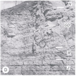
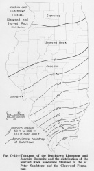
The Joachim Dolomite is exposed in Illinois only in Calhoun County (fig. O-2D), where the Mississippi River cuts through the Lincoln Anticline. However, it underlies all of Illinois south of a line extending from near Quincy to Kankakee (fig. O-18). North of there it has a gradational contact with the Starved Rock Member of the St. Peter Sandstone. The Joachim thins northward by progressive termination of the basal Joachim strata. It is as much as 385 feet thick in extreme southern Illinois.
Description
The Joachim Dolomite has a highly varied lithology, but individual units are widely persistent. Although largely light gray, argillaceous, silty or sandy dolomite, it contains beds of brownish gray, relatively pure dolomite, beds of sandstone and limestone, some thin shale beds, and numerous algal domes of pure dolomite. In the outcrop area, chert occurs only near the middle, but it is more common in the subsurface in Illinois. Layers of anhydrite in the subsurface appear to have been dissolved in the outcrop area, producing the brecciated layers that are common in the dolomite. Mud cracks and ripple marks are common in some beds. The general absence of marine fossils suggests that the Joachim was deposited in a shallow, closed basin. The Joachim contains much more clastic material than the Platteville strata above, which are dominantly limestone in the area where the Joachim is present. It is lighter colored than the Dutchtown below. The Joachim Dolomite is best exposed on the flanks of the Ozark Dome in Missouri, and it is differentiated into six members on the basis of exposures in that area. The Abernathy Member (at the base) is sandy, the Augusta is thick bedded and silty, the Boles is thin bedded and shaly, the Defiance is thick bedded and silty, the Matson is brown, pure, and massive, and the Metz (at the top) is thin bedded and silty. Only the Metz, Matson, and the top of the Defiance are exposed in Illinois, but all the members can generally be recognized in samples from wells. All are successively overlapped northward.
References
MCQUEEN, H. S., 1937, Dutchtown, a new Lower Ordovician formation in southeastern Missouri: Missouri Geological Survey and Water Resources, 59th Biennial Report, 1935-1936, app. 1 , 27 p.
TEMPLETON, J. S., and H. B. WILLMAN, 1963, Champlainian Series (Middle Ordovician) in Illinois: Illinois State Geological Survey Bulletin 89, 260 p.
WINSLOW, ARTHUR, 1894, Lead and zinc deposits-Part 1: Missouri Geological Survey, v. 6, 387 p.
ISGS Codes
| Stratigraphic Code | Geo Unit Designation |
|---|---|


