Historical:Glenwood Formation
Lithostratigraphy: Ottawa Limestone Megagroup >>Ancell Group >>Glenwood Formation
Chronostratigraphy: Paleozoic Erathem >>Ordovician System >>Champlainian Series >>Blackriveran Stage
Allostratigraphy: Tippecanoe Sequence
Authors
H. B. Willman and T. C. Buschbach
Name Origin
The Glenwood Formation (Calvin, 1906, p. 60-61 ; Bevan, 1926, p. 6), a highly varied unit of sandstone, dolomite, and shale overlying the St. Peter Sandstone, is named for Glenwood Township, Winneshiek County, northeastern Iowa.
Type Section
The type section of the Glenwood Formation is in a ravine 3 miles northeast of Decorah (SE SW 6, 98N-7W).
Extent and Thickness
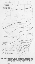
The Glenwood Formation is widely present in northern Illinois (fig. O-18). It is exposed in Illinois only in the Rock River region above Dixon. Although absent in some localities, especially near the Wisconsin state line, thicknesses of 25-50 feet are common and the formation is as much as 75 feet thick in places.
Stratigraphic Position
The Glenwood Formation underlies the Platteville Group, from which it is separated by an unconformity that is widespread and sharp but has only minor relief. The Glenwood Formation is subdivided into five members- the Kingdom Sandstone Member at the base is overlain by the Daysville Dolomite Member, the Loughridge Sandstone Member, and the Harmony Hill Shale Member. The lower three have gradational contacts and generally thicken and thin at the expense of each other. Locally in northwestern Illinois the Daysville Dolomite Member is absent, and the name "Nokomis Sandstone Member" is applied to all the sandstone of Glenwood type underlying the Harmony Hill Shale. In extreme western Illinois the St. Peter Sandstone is overlain by a green shale, above which a well sorted St. Peter-like sandstone is informally called the "Re-Peter" sandstone. In Illinois the green shale has been correlated with the Kingdom Sandstone and the "Re-Peter" with the Starved Rock Sandstone (Templeton and Willman, 1963). In Iowa the green shale has been correlated (Agnew, 1955) with type Glenwood Shale, which is the Harmony Hill Shale. If the latter is correct, the "Re-Peter" may correlate with the Hennepin Sandstone Member, which in places is a St. Peter-like sandstone at the base of the overlying Pecatonica Formation.
Description
The Glenwood Formation is characteristically poorly sorted sandstone, impure dolomite, and green shale. The sandstones have a distinctive bimodal, or "pudding stone," texture, with medium grains of well rounded quartz sand, like those of the St. Peter Sandstone, in a matrix of very fine sand and coarse silt. This is frequently referred to as Glenwood texture, in contrast to the well sorted St. Peter texture. The Glenwood sandstones also contain a variety of heavy minerals, including abundant garnet, whereas the St. Peter has a very low content of a limited suite of heavy minerals, consisting largely of tourmaline and zircon.
Fossils
The Glenwood Formation contains a few worm borings, a few scolecodonts, and, in places, dark red algae or spores.
References
AGNEW, A. F., 1955, Facies of Middle and Upper Ordovician rocks of Iowa: American Association of Petroleum Geologists Bulletin, v. 39, p. 1703-1752.
BEVAN, A. C., 1926, Glenwood beds as a horizon marker at the base of the Platteville Formation: Illinois State Geological Survey Report of Investigations 9, 13 p.
CALVIN, SAMUEL, 1906, Geology of Winneshiek County: Iowa Geological Survey, v. 16, p. 37-146.
TEMPLETON, J. S., and H. B. WILLMAN, 1963, Champlainian Series (Middle Ordovician) in Illinois: Illinois State Geological Survey Bulletin 89, 260 p.
ISGS Codes
| Stratigraphic Code | Geo Unit Designation |
|---|---|

