Historical:Edgewood Formation
Lithostratigraphy: Hunton Limestone Megagroup >>Edgewood Formation
Chronostratigraphy: Paleozoic Erathem >>Silurian System >>Alexandrian Series
Allostratigraphy: Tippecanoe Sequence
Authors
H. B. Willman and Elwood Atherton
Name Origin
The Edgewood Formation is named for exposures near Edgewood, Pike County, Missouri.
Extent and Thickness
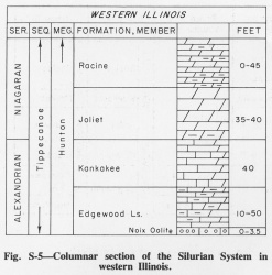
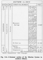
The Edgewood is as much as 50 feet thick where exposed along the Lincoln Anticline in Calhoun and Jersey Counties, but in places it is reduced to 10 feet or less where it is truncated by the Kankakee Formation (Rubey, 1952). The upper 33 feet is well exposed in a quarry at Monterey School, Calhoun County (NE SW 11, 12S-2W), and at Twin Springs in Pere Marquette State Park in Jersey County (NW SE 9, 6N- 13W) (Collinson et al., 1954). The Edgewood Formation is also exposed along and near the Mississippi River in Alexander County in southern Illinois, where its maximum thickness is about 4 feet and it is locally absent. It thickens eastward in subsurface to as much as 60 feet. Good exposures occur in roadcuts near Gale (NE NE NW 4, 15S-3W) (Pryor and Ross, 1962).
Stratigraphic Position
The Edgewood Formation (Savage, 1909, p. 517-518) (figs. S-5, S-6) is the basal Alexandrian formation in western and southern Illinois.
Description
The formation varies from a soft, fine-grained, thin- to medium-bedded, argillaceous, brown, dolomitic limestone containing disseminated fine sand in the northern part of the outcrop area, to a hard, massive, porous, brown dolomite or very dolomitic limestone in the southern part. In the northern part the lower few feet is a massive gray oolite or oolitic limestone-- the Noix Oolite Member. The oolite is fossiliferous in places, but the remainder of the formation contains few fossils (Savage, 1913). In southern part the Edgewood is a massive, gray, crystalline limestone. The lower 2 feet is a conglomerate of pebbles from the Girardeau Limestone, mixed with oolites and fine quartz sand in a clear calcite matrix. The oolitic bed is assigned to the Noix Oolite Member. The oolite is also locally present in subsurface throughout southern Illinois.
References
COLLINSON, CHARLES, D. H. SWANN, and H. B. WILLMAN, 1954, Guide to the structure and Paleozoic stratigraphy along the Lincoln Fold in western Illinois: Illinois State Geological Survey Guidebook Series 3, 75 p.
PRYOR, W. A., and C. A. ROSS, 1962, Geology of the Illinois parts of the Cairo, La Center, and Thebes Quadrangles: Illinois State Geological Survey Circular 332, 39 p.
RUBEY, W. W., 1952, Geology and mineral resources of the Hardin and Brussels Quadrangles: USGS Professional Paper 218, 179 p.
SAVAGE, T. E., 1909, Ordovician and Silurian formations in Alexander County, Illinois: American Journal of Science, v. 28, p. 509-519.
SAVAGE, T. E., 1913, Stratigraphy and paleontology of the Alexandrian Series in Illinois and Missouri, Part 1: Illinois State Geological Survey Extract Bulletin 23, 124 p.; 1917, Illinois State Geological Survey Bulletin 23, p.
ISGS Codes
| Stratigraphic Code | Geo Unit Designation |
|---|---|


