Silurian System
Chronostratigraphy: Paleozoic Erathem >>Silurian System
Primary source
Willman, H. B., Elwood Atherton, T. C. Buschbach, Charles Collinson, John C. Frye, M. E. Hopkins, Jerry A. Lineback, and Jack A. Simon, 1975, Handbook of Illinois Stratigraphy: Illinois State Geological Survey Bulletin 95, 261 p.
Contributing author(s)
H. B. Willman and Elwood Atherton
Name
Original description
The Silurian System (Murchison, 1835, p. 48-49; Lapworth, 1879, p. 12-14).
Derivation
Named for the Silures, a tribe of people who lived in the type area in Wales during Roman times.
Other names
History/background
Type section
Type location
Type author(s)
Type status
Reference section
Reference location
Reference author(s)
Reference status
Stratigraphic relationships
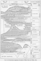
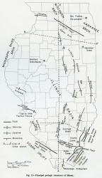
In the classification based on major unconformities, the Silurian rocks belong to the Tippecanoe Sequence (fig. 14). They are separated from the underlying Ordovician rocks by an unconformity, as previously described. In the part of the Illinois Basin south of the reefs, deposition appears to have been essentially continuous from Silurian to Devonian time, but the sub-Kaskaskia unconformity at the base of the Middle Devonian rocks truncates the reefs and the Niagaran, Lower Devonian, and Cayugan rocks on the flanks of the reefs. Cayugan and Lower Devonian sediments may not have been deposited north of the area of the Moccasin Springs Formation (fig. S-1), but if they were present they must have been eroded, because the unconformity cuts deeply into Niagaran strata in that area. Well rounded, medium-grained quartz sand found locally in upper Silurian rocks in subsurface is largely Middle Devonian sand introduced along joints (Summerson and Swann, 1970). In extreme western Illinois, the Silurian strata were entirely eroded before the Middle Devonian limestone was deposited. No major unconformities are recognized within the Silurian System, although sharp contacts and channeling between the Kankakee and Edgewood Formations in western Illinois and the Sexton Creek and Edgewood Formations in southern Illinois may indicate movements on local structures on the flank of the Ozarks. The Alexandrian and Niagaran rocks are separated by a widespread, smooth surface that probably indicates a diastem.
Extent and thickness
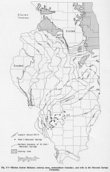
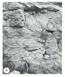
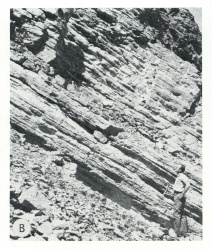
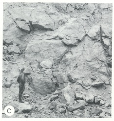
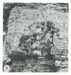
Rock of the Silurian System underlie most of Illinois and is the surface of the bedrock in four areas (fig. S-1). Silurian strata are well exposed in all four areas (fig. S-2). In northeastern Illinois, Silurian rocks are exposed in large, deep quarries in the Chicago region and in the bluffs of the Des Plaines, Kankakee, Du Page, and Fox Valleys, but in the northern half of that area they are deeply buried by glacial drift. In northwestern Illinois, the Silurian strata are the resistant rocks that cap nearly all the mounds, and they are well exposed in the Mississippi River bluffs from the Galena area southward to the Rock Island vicinity and also along tributary valleys for several miles east of the bluffs. In western Illinois, the Silurian System has been uplifted along the Lincoln Anticline and the Cap au Grès Faulted Flexure and is well exposed in the Mississippi and Illinois River bluffs in Jersey and Calhoun Counties. In southern Illinois, the exposures are limited to the Mississippi bluffs and tributary valleys in Alexander County and southern Union County. The Silurian rocks in all these areas were long called Niagara Limestone (Worthen, 1866; Bannister, 1868; Shaw, 1873). The Silurian System has a maximum thickness of nearly 1000 feet in and below some pinnacle reefs in the area east of East St. Louis. However, the system is more commonly 400-600 feet thick in that area and farther north (fig. S-1). South of the pinnacle reefs the Silurian rocks are generally only 300-400 feet thick.
|
Lithology
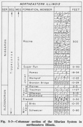
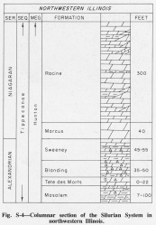
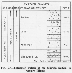
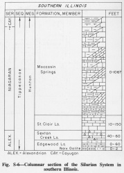
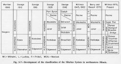
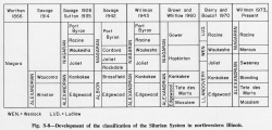
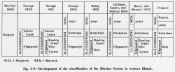
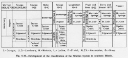
The Silurian System is subdivided into three series-the Alexandrian Series (below), which is based on exposures in Alexander County, Illinois, and the Niagaran and Cayugan Series, both based on exposures in the Niagara Falls area in New York and Ontario. Because of pronounced changes in lithology, different rock-stratigraphic classifications have developed in the widely separated outcrop areas in Illinois, and 15 formations and 10 members are now recognized (figs. S-3 to S-10). The subsurface correlations between the outcrop areas have not been firmly established for some units.
The Silurian rocks are dominantly carbonates-- almost entirely dolomite in the northern part of the state (Willman, 1943, 1973) but largely limestone, siltstone, and shale in the southern part (Lowenstam and DuBois, 1946; Lowenstam, 1949). With the overlying Devonian carbonate rocks, they form the Hunton Limestone Megagroup.
The Alexandrian formations, the lower Niagaran rocks, and all of the Silurian rocks south of the reefs maintain distinctive characteristics and lateral continuity for long distances (fig. S-11), but where reefs are present the sediments have abrupt lateral variations in lithology, and few units can be widely traced. The reefs are very pure carbonate. The northern reefs, in the Racine Formation, are mainly dolomite, but the southern reefs, in the Moccasin Springs Formation, are largely limestone. The interreef rocks are less pure, varying from cherty silty dolomite to argillaceous dolomite around the Racine reefs and from argillaceous limestone to calcareous shale and siltstone around the Moccasin Springs reefs. However, in northwestern Illinois the interreef rocks, except in local areas, are nearly pure dolomite and are similar in lithology to the reef rock.
Core(s)
Photograph(s)
Contacts
Well log characteristics
Fossils
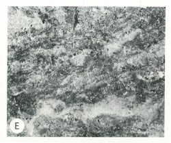
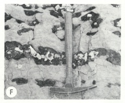
Fossils are generally abundant in the relatively pure carbonate rocks of the Silurian System (fig. S-12) but are scarce in the more argillaceous and silty strata. Five faunal zones are extensive. (1) The Platymerella Zone at the base of the Kankakee Formation is essentially equivalent to the Virgiana Zone found to the north in Wisconsin, Michigan, and Ontario. The two fossils are closely related pentamerids. (2) The Microcardinalia Zone at the top of the Kankakee Formation and in the upper part of the Sweeney Formation is widely present at the top of Alexandrian rocks. (3) A zone of abundant arenaceous Foraminifera, characterized by Ammodiscidae, occurs at the base of Niagaran strata, although it has not been found in northwestern Illinois. (4) The Pentamerus Zone, which in Illinois occurs only in the northwestern part of the state, is regionally present at or near the base of the Niagaran Series. (5) The uppermost Niagaran reefs in northeastern Illinois contain distinctive fossils characteristic of the Guelph Formation of New York and Ontario, referred to as the Guelph fauna, or the Megalomus Zone. Megalomus is present but not common in the youngest Niagaran strata in both northeastern and northwestern Illinois. Fossils characteristic of the Guelph are also found in the top of the reef at Marine, Madison County (Lowenstam, 1949).
The Niagaran reefs are very fossiliferous and contain a great variety of invertebrates, especially stromatactis-like forms, corals, stromatoporoids, bryozoans, brachiopods, and crinoids (Lowenstarn, 1949, 1950, 1957; Ingels, 1963; and others), whereas the interreef rocks are sparsely fossiliferous and the fauna, principally sponges, crinoids, and brachiopods, differs in many aspects from that of the reefs (Lowenstam, 1948a).
Age and correlation
Environments of deposition
Illinois was almost continuously beneath the sea during Silurian time. The most striking features in the Silurian sea were the reefs that formed in Niagaran time in a broad area reaching from the Ozark region northeastward across Illinois, Indiana, and Ohio to Ontario (Lowenstam, 1949, 1957). Another group of reefs in northwestern Illinois, Iowa, northeastern Illinois, and eastern Wisconsin may have been part of an archipelago bordering the Wisconsin Arch. The two belts of reefs essentially meet in the Kankakee Arch area and form part of a barrier around the Michigan Basin.
In the relatively deep water south of the reef front and around the southernmost reefs, the sediments that were deposited during the growth of the reefs are largely red, green, gray, impure, noncherty limestone, siltstone, and shale; farther north, the reefs are surrounded by gray, cherty, silty dolomite. The red sediments are more dominant to the southwest and probably were derived from that direction.
In the southern reef area, the oldest reefs probably began to grow during deposition of the upper part of the St. Clair Formation, as indicated by the presence of local lenses of pure sediments, probably wash from reefs. However, the major reefs began to grow a little later, at or just above the base of the Moccasin Springs Formation. In the northern areas, major reef growth began at approximately the same time as in the south, the beginning of Racine deposition. The great thickness of the southern reefs appears to be related to the progressive sinking of the deep part of the Illinois Basin, the Fairfield Basin (fig. 12).
The reefs continued as prominent features through Silurian time, although the presence of Niagaran fossils in the upper parts of some reefs suggests that reef growth did not extend into Cayugan time. However, as all of the reefs are overlain unconformably by Middle Devonian or younger sediments, the Cayugan, and perhaps even the early Devonian, parts of the reefs could have been present and eroded. In either case, the sea continued to occupy the Illinois Basin around and south of the reefs into Devonian time, and several hundred feet of Lower Devonian sediments were deposited in the basin and largely filled it.
Economic importance
Remarks
References
BANNISTER, H. M., 1868, Geology of Cook County: Geological Survey of Illinois, v. 3, p. 239-256.
INGELS, J. J. C., 1963, Geometry, paleontology, and petrography of Thornton Reef Complex, Silurian of northeastern Illinois: American Association of Petroleum Geologists Bulletin, v. 47, p. 405-440.
LAPWORTH, C., 1879, On the tripartite classification of the lower Paleozoic rocks: Geological Magazine, New Series, Decade II, v. 6, p. 1-15.
LOWENSTAM, H. A., 1948a, Biostratigraphic studies of the Niagaran inter-reef formations in northeastern Illinois: Illinois State Museum Science Papers, v. 4, 146 p.
LOWENSTAM, H. A., 1949, Niagaran reefs in Illinois and their relation to oil accumulation: Illinois State Geological Survey Report of Investigations 145, 36 p.
LOWENSTAM, H. A., 1950, Niagaran reefs of the Great Lakes area: Journal of Geology, v. 58, p. 430-487.
LOWENSTAM, H. A., 1957, Niagaran reefs in the Great Lakes area, in Treatise on marine ecology and paleoecology: Geological Society of America Memoir 67, v. 2, p. 215-248.
LOWENSTAM, H. A., and E. P. DUBOIS, 1946, Marine pool, Madison County, a new type of oil reservoir in Illinois: Illinois State Geological Survey Report of Investigations 114, 30 p.
MURCHISON, R. I., 1835, On the Silurian System of rocks: London and Edinburgh Philosophical Magazine and Journal of Science, 3rd Series, v. 7, p. 46-52.
SHAW, JAMES, 1873, Geology of northwestern Illinois: Geological Survey of Illinois, v. 5, p. 1-94.
SUMMERSON, C. H., and D. H. SWANN, 1970, Patterns of Devonian sand on the North American craton and their interpretation: Geological Society of America Bulletin, v. 81, p. 469-490; Illinois State Geological Survey Reprint 1970-D.
WILLMAN, H. B., 1943, High-purity dolomite in Illinois: Illinois State Geological Survey Report of Investigations 90, 89 p.
WILLMAN, H. B., 1973, Rock stratigraphy of the Silurian System in northeastern and northwestern Illinois: Illinois State Geological Survey Circular 479, 55 p.
WORTHEN, A. H., 1866, Geology: Geological Survey of Illinois, v. 1, 504 p.
ISGS Codes
| Stratigraphic Code | Geo Unit Designation |
|---|---|
