Historical:Battery Rock Sandstone Member
Lithostratigraphy: McCormick Group >>Caseyville Formation >>Battery Rock Sandstone Member
Chronostratigraphy: Paleozoic Erathem >>Pennsylvanian Subsystem >>Morrowan Series
Allostratigraphy: Absaroka Sequence
Authors
M. E. Hopkins and J. A. Simon
Name Origin
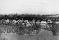
The Battery Rock Sandstone Member of the Caseyville Formation (Cox, 1875, p. 204) is named for Battery Rock, a bluff of massive sandstone on the west bank of the Ohio River in Hardin County.
Type Section
The type section is Battery Rock, on the west bank of the Ohio River in Hardin County (26, 11S-10E).
Correlation
The Battery Rock is correlated with the lower Caseyville conglomerate, or Kyrock Sandstone Member, of western Kentucky and with the lower part of the Mansfield Sandstone of Indiana.
Extent and Thickness
The Battery Rock Sandstone, a prominent bluff-forming unit (fig. P-3A), is very well developed in Gallatin, Hardin, and Pope Counties, where it is 50-100 feet thick in a large area. It is also as much as 100 feet thick in the western part of the southern Illinois outcrop belt, but there it is more lenticular. Along the southwestern side of the Illinois Basin, the sandstone extends only as far north as Randolph County. In the subsurface to the north and northeast of the outcrop belt, the Battery Rock is difficult to trace because several other thick sandstone units occur in the lower part of the McCormick Group.
Description
The Battery Rock is generally medium-grained sandstone, but at places it becomes coarse; almost everywhere it contains scattered quartz granules and pebbles, which in places form conglomerate beds. Although the Caseyville sandstones have been called conglomerates, the term "conglomeratic" is more appropriate.
References
COX, E. T., 1875, Geology of Gallatin County: Geological Survey of Illinois, v. 6, p. 197-219.
ISGS Codes
| Stratigraphic Code | Geo Unit Designation |
|---|---|

