Dykersburg Shale Member
Lithostratigraphy: Carbondale Formation >>Dykersburg Shale Member
Chronostratigraphy: Paleozoic Erathem >>Pennsylvanian Subsystem >>Desmoinesian Series
Allostratigraphy: Absaroka Sequence
Primary source
Nelson, W.J., P.H. Heckel and J.M. Obrad, 2022, Pennsylvanian Subsystem in Illinois: Illinois State Geological Survey, Bulletin (in press).
Contributing author(s)
W.J. Nelson
Name
Original description
Hopkins (1968, p. 4) proposed the name Dykersburg Shale Member for gray silty shale that overlies the Springfield Coal and underlies the black shale (Turner Mine) in southeastern Illinois. Hopkins mapped the Dykersburg and related its occurrence to deposits of thick, low-sulfur coal along what was later named the Galatia channel. This was a breakthrough report in terms of understanding how the coal thickness and quality in Illinois relate to the depositional setting.
Derivation
The community now called Dykersburg originally was Absher, named for William A. Absher, its first postmaster (1892). For reasons unknown, the name was changed to Dykersburg in 1898. The post office closed in 1908, and the last business shut down in 1970. A small cluster of houses remains (Sneed 1977).
Other names
None.
History/background
See above.
Type section
Type location
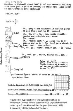
The stratotype is the highwall of an abandoned strip mine near Dykersburg (SE¼ SE¼ NE¼ sec. 34, T 9 S, R 4 E, Williamson County, Carrier Mills 7.5' quadrangle). No description was published, but Hopkins (1968) reported the Dykersburg to be about 15 ft (4.5 m) thick. A graphic section from field notes (Figure 4-58) shows that the base of the Dykersburg was under water at the time the section was proposed as the type.
Type author(s)
Hopkins (1968, p. 4).
Type status
Shale exposures in abandoned strip mines do not last long. Google Earth imagery shows the old pits around Dykersburg to be flooded and densely wooded.
Reference section(1)
Reference location
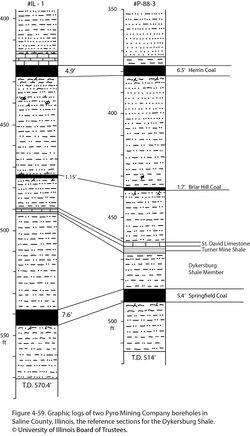
Selected as the primary reference section is continuous core from Pyro Mining Company hole no. IL-1, drilled in sec. 27, T 7 S, R 7 E, Saline County (ISGS county no. 25748). The Dykersburg Member is 48.0 ft (14.6 m) thick and lies at the depth interval of 491.9 to 537.9 ft (149.9 to 164.0 m; Figure 4-59).
Reference author(s)
Present report.
Reference status
Logs of #IL-1 are on file at the Geological Records Unit of the ISGS and are accessible via the ISGS website. Core is archived at the Geological Samples Library of the ISGS under call number C-13369.
Reference section(2)
Reference location
As an alternate reference, we designate continuous core from the Pyro Mining Company, hole no. P-88-3, located 500 ft (152.4 m) from the south line, 2,590 ft (789.4 m) from the east line, sec. 4, T 8 S, R 7 E. The county number is 25788. The Dykersburg is 18.8 ft (5.73 m) thick and is in the depth interval from 467.0 to 485.8 ft (Figure 4-59).
Reference author(s)
Present report.
Reference status
Logs of no. P-88-3 are on file at the Geological Records Unit of the ISGS and are accessible via the ISGS website. Core is archived at the ISGS Geological Samples Library in Champaign under call number C-13372.
Stratigraphic relationships
The Dykersburg directly overlies the Springfield Coal in irregular belts along both sides of the Galatia channel in southeastern Illinois and southwestern Indiana. The Turner Mine Shale and St. David Limestone overlap the Dykersburg, but where the latter is thick, the former tends to pinch out, bringing the Dykersburg into direct contact with the younger Canton Shale. Differentiating the Canton from the Dykersburg can be difficult, although the Briar Hill Coal tends to persist between the shale units even where the Dykersburg is thickest.
In underground mines near the Galatia channel, wedge-shaped bodies of Dykersburg strata “split” the coal seam and lie between coal and underclay. Large-scale rafting of peat with clastic sediment deposited between or below layers of floating peat may explain these disruptions.
Extent and thickness
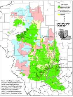
As mapped by Hopkins (1968) and Eggert (1994), the Dykersburg occupies an irregular southwest-trending belt along the Galatia channel (Figure 4-57). This belt widens from about 9 to 12 mi (15 to 20 km) in Indiana to 31 mi (50 km) in southern Illinois. Distribution of the shale relative to the channel is not symmetrical. Most of the thick shale is southeast of the channel in Indiana, whereas thick shale in southern Illinois is largely northwest of the channel. The maximum thickness of the Dykersburg increases from about 80 ft (24 m) in Indiana to as much as 125 ft (38 m) in Saline County, Illinois. The Dykersburg occurs as isolated pods and lenses outside the area where it is thick and continuous. Mapping in underground mines shows that most lenses are 3 to 10 ft (1 to 3 m) thick and several tens of feet (meters) to roughly 330 ft (100 m) across. Including these lenses, the width of the Dykersburg tract is 50 to 56 mi (80 to 90 km) along the southern outcrop. The extent of Dykersburg lenses farther north is poorly known because less underground mining has taken place there.
Lithology
Core drilling and exposures in underground mines provide many details on the lithology of the Dykersburg. Medium to medium-dark gray silty mudstone and fine- to coarse-grained siltstone are the most prevalent rock types. Bedding and lamination tend to be inconspicuous; much of the siltstone is nearly massive. Where the Dykersburg is thickest, it includes sandstone that is light gray and very fine to fine grained, occurring as laminae, lenses, interbeds, and larger lens-shaped bodies. Volumetrically minor, dark gray fissile clay-shale (no silt) is mostly confined to the basal part of the Dykersburg, in contact with the Springfield Coal. Regular bands, nodules, and small concretions of siderite are common in finer grained facies of the Dykersburg. Small pyrite nodules occur in dark, carbonaceous shale, especially near the base of the member. Sedimentary structures include planar, wavy, ripple, flaser, and cross lamination together with small load casts, ball-and-pillow structures, and deformed or contorted lamination (soft-sediment deformation). Much of the lamination consists of strongly rhythmic bundles of thin clay-rich laminae alternating with bundles of thicker silt- or sand-rich laminae. This style of lamination is diagnostic of neap and spring tidal cycles (Archer and Kvale 1993; Archer et al. 1994, 2016). We have observed examples of tidal rhythmites through most of the geographic extent of the Dykersburg and at various levels in vertical profiles of the unit. The only places where rhythmites are not developed are at the thin edges of the Dykersburg, where the member is reduced to isolated lenses.
Although sandstone occurs mostly in the upper part of the Dykersburg, locally it is found directly on the Springfield Coal. Sandstone bodies are lens shaped in cross section. Their lower contacts are erosive, truncating underlying shale and flowing “rolls” in the coal (see below). Some sandstone bodies are convex upward, grading laterally to siltstone and mudstone. Near the Galatia channel, bedding of the Dykersburg offlaps the coal at angles as steep as 30 degrees, indicating rapid progradation of sedimentary wedges.
Core(s)
Photograph(s)
Contacts
The contact to the Springfield Coal generally is sharp but can be gradational through a thin zone of impure coal and carbonaceous shale. Rarely, the Dykersburg “splits” the coal (see Stratigraphic relationships, above). Contact to the Turner Mine Shale is sharp in most places and likely is erosive. A gradational contact may be seen where the Dykersburg is thick.
Well log characteristics
Typical for gray shale, siltstone, and argillaceous sandstone. Hopkins (1968) published electric log cross sections illustrating the Dykersburg.
Fossils
Fossil land plants are widely distributed. They are profuse and beautifully preserved in the basal layers near the Galatia channel where the Dykersburg is thickest (e.g., DiMichele and Nelson 1989). Fossils are preserved as compressions; that is, they are carbonized or coalified and stand out against the gray shale matrix. Also common near the channel are fossil tree stumps, which occur in growth position, rooted in the top of the Springfield Coal. A few stigmarian roots have been found in the plant-rich basal part of the shale, but these probably were transported (e.g., as floating stumps) from their site of growth. The only invertebrate fossils are the inarticulate brachiopod Lingula and pectenoid pelecypods such as Dunbarella. Indicative of brackish water, these forms occur chiefly on the outer margins of the Dykersburg. A few trace fossils have been seen in cores, mostly in the upper part of the member. They are mostly vertical and inclined burrows, some, such as Teichichnus, with gutter stacking. Horizontal burrows are rare; no trails or feeding traces have been observed. Root traces are nonexistent except at the top of the Dykersburg directly beneath the Briar Hill Coal.
Age and correlation
No comparable unit has been reported in the Midcontinent, where the black, phosphatic Binkley Shale Member rests directly on the Summit Coal (Turner Mine Shale and Springfield Coal equivalents). The presence of a Dykersburg analogue in the northern Appalachian Basin is unknown because no black shale similar to the Turner Mine overlies the Middle Kittanning or Princess No. 7 coal beds.
Environments of deposition
Beyond implying a nonmarine origin, Hopkins (1968) did not address the environment of the Dykersburg. Subsequent authors, such as Johnson (1972) and Allgaier and Hopkins (1975), invoked a model patterned after the modern Mississippi delta. The latter (p. 14) stated, “The characteristic pattern of these shales [Energy and Dykersburg] and their association with coal and channels suggests a depositional model whereby floods causing breaks in levees along the banks of channels, which ran through the coal swamp, resulted in crevasse splays of gray shale wedges over coal (peat) deposits . . .” Hopkins et al. (1979) referred to the Dykersburg and Energy Shales as crevasse splay deposits derived from the channels. Summarizing earlier work, Nelson (1983b, figure 8) illustrated Galatia channel environments including levees, crevasse splays, and a bird-foot delta like that of the Mississippi. Nelson et al. (1987, p. 12–14) departed slightly, noting the lack of evidence for natural levees but clinging to an overall deltaic setting. Burk et al. (1987) continued to interpret the Energy Shale in terms of deltaic crevasse splays. In Indiana, Eggert (1982) and Eggert and Adams (1985) also related channel development in Indiana to the modern Mississippi delta. They envisioned the Galatia and associated channels as deltaic distributaries, flanked by natural levees that frequently failed, spilling sediment-laden water into adjoining peat swamps. Eggert (1994, p. 14) regarded the Galatia channel as part of a delta that prograded seaward during peat deposition and (p. 16) alluded to the Dykersburg Shale as lacustrine and overbank mud.
Archer and Kvale (1993) and Archer et al. (1994, 2016) recognized rhythmic lamination and other tidal signatures in Illinois gray shale associated with low-sulfur coal. These authors favored deposition in an estuarine environment rather than a fluvially dominated delta, and they ascribed much of the Dykersburg to tidal mudflats that formed during the early stages of marine transgression while the Galatia channel transitioned from a river to an estuary.
All aspects of the Dykersburg point to rapid deposition in a moderately energetic, tide-dominated regime. Fossil tree stumps in growth position, scouring of the peat top (rolls), large peat mats torn loose from the main deposit, superb preservation of delicate plant fossils, sparse brackish-water fauna, the scarcity of burrowing, the near absence of rooting, prevalent tidal rhythmites, common slump and load features, and large-scale clinoform bedding support this view. Restriction of the Dykersburg to a funnel-shaped deposit along a preexisting valley indicates the setting was an estuary that opened to the southwest. The Francis Creek Shale exhibits nearly all the same features and likewise has been interpreted as an estuarine deposit (Kuecher et al. 1990).
Evidently, the valley of the Galatia channel was the lowest part of the Springfield peat swamp. During early stages of the marine transgression that drowned the swamp, this valley became an estuary. Fluvial sediment from upland (or, less likely, offshore) buried the peat. With continuing sea-level rise, waves and currents scoured the Dykersburg sediment, resulting in a lobate to podlike distribution of gray shale.
Economic importance
Thick Dykersburg Shale is genetically related to low-sulfur Springfield Coal. As a mine roof, the Dykersburg is weak to moderately competent.
Remarks
References
- Allgaier, G.J., and M.E. Hopkins, 1975, Reserves of the Herrin (No. 6) Coal in the Fairfield Basin in southeastern Illinois: Illinois State Geological Survey, Circular 489, 31 p., 2 pls.
- Archer, A.W., S.D. Elrick, W.J. Nelson, and W.A. DiMichele, 2016, Cataclysmic burial of Pennsylvanian coal swamps in the Illinois Basin: Hypertidal sedimentation during the Gondwanan glacial melt-water pulses, in Contributions to Modern and Ancient Tidal Sedimentology, Proceedings of the Tidalites 2012 Conference: International Association of Sedimentologists Special Publication, v. 47, p. 217–231.
- Archer, A.W., H.R. Feldman, E.P. Kvale, and W.P. Lanier, 1994, Comparison of drier- to wetter-interval estuarine roof facies in the Eastern and Western Interior coal basins, USA: Palaeogeography, Palaeoclimatology, Palaeoecology, v. 106, p. 171–185.
- Archer, A.W., and E.P. Kvale, 1993, Origin of gray shale lithofacies (“clastic wedges”) in U.S. midcontinental coal measures (Pennsylvanian): An alternative explanation: Geological Society of America, Special Paper 286, p. 181–192.
- Burk, M.K., M.P. Deshowitz, and J.E. Utgaard, 1987, Facies and depositional environments of the Energy Shale Member (Pennsylvanian) and their relationship to low-sulfur coal deposits in southern Illinois: Journal of Sedimentary Petrology, v. 57, no. 6, p. 1060–1067.
- DiMichele, W.A., and W.J. Nelson, 1989, Small-scale spatial heterogeneity in Pennsylvanian-age vegetation from the roof shale of the Springfield Coal (Illinois Basin): Palaios, v. 4, p. 276–280.
- Eggert, D.L., 1982, A fluvial channel contemporaneous with deposition of the Springfield Coal Member (V), Petersburg Formation, northern Warrick County, Indiana: Indiana Geological Survey, Special Report 28, 20 p.
- Eggert, D.L., 1994, Coal resources of Gibson County, Indiana: Indiana Geological Survey, Special Report 50, 36 p. and 1 pl.
- Eggert, D.L., and S.C. Adams, 1985, Distribution of fluvial channel systems contemporaneous with the Springfield Coal Member (Middle Pennsylvanian) in southwestern Indiana, in A.T. Cross, ed., Economic geology: Coal, oil and gas: Ninth International Congress of Carboniferous Geology and Stratigraphy, Proceedings, v. 4: Carbondale, Southern Illinois University Press, p. 342–348.
- Hatch, J.R., and R.H. Affolter, 2002, Resource assessment of the Springfield, Herrin, Danville, and Baker Coals in the Illinois Basin: U.S. Geological Survey, Professional Paper 1625-D, version 1.0, https://pubs.usgs.gov/pp/1625d/report.pdf (accessed October 2, 2020).
- Hopkins, M.E., 1968, Harrisburg (No. 5) Coal reserves of southeastern Illinois: Illinois State Geological Survey, Circular 431, 25 p., 2 pls.
- Hopkins, M.E., R.B. Nance, and C.G. Treworgy, 1979, Mining geology of Illinois coal deposits, in J.E. Palmer and R.R. Dutcher, eds., Depositional and structural history of the Pennsylvanian System in the Illinois Basin, Part 2, Invited papers: Ninth International Congress of Carboniferous Stratigraphy and Geology, Field Trip 9: Illinois State Geological Survey, Guidebook 15A, p. 142–151.
- Johnson, D.O., 1972, Stratigraphic analysis of the interval between the Herrin (No. 6) Coal and the Piasa Limestone in southwestern Illinois: Urbana, University of Illinois, Ph.D. thesis, 105 p.
- Kuecher, G.J., B.G. Woodland, and F.M. Broadhurst, 1990, Evidence of deposition from individual tides and of tidal cycles from the Francis Creek Shale (host rock to the Mazon Creek biota), Westphalian D (Pennsylvanian), northeastern Illinois: Sedimentary Geology, v. 68, p. 211–221.
- Nelson, W.J., 1983b, Geologic disturbances in Illinois coal seams: Illinois State Geological Survey, Circular 530, 47 p.
- Nelson, W.J., P.J. DeMaris, and R.A. Bauer, 1987, The Hornsby district of low-sulfur Herrin Coal in central Illinois (Christian, Macoupin, Montgomery, and Sangamon Counties): Illinois State Geological Survey, Circular 540, 40 p., 1 pl.
- Sneed, G.J., 1977, Ghost towns of southern Illinois: A.E.R.P., Publisher, Johnston City, Illinois, 309 p.
ISGS Codes
| Stratigraphic Code | Geo Unit Designation |
|---|---|


