Burlington Limestone
Lithostratigraphy: Mammoth Cave Limestone Megagroup >>Burlington Limestone
Chronostratigraphy: Paleozoic Erathem >>Mississippian Subsystem >>Valmeyeran Series
Allostratigraphy: Kaskaskia Sequence
Primary source
Willman, H. B., Elwood Atherton, T. C. Buschbach, Charles Collinson, John C. Frye, M. E. Hopkins, Jerry A. Lineback, and Jack A. Simon, 1975, Handbook of Illinois Stratigraphy: Illinois State Geological Survey Bulletin 95, 261 p.
Contributing author(s)
Elwood Atherton, Charles Collinson, and Jerry A. Lineback
Name
Original description
Burlington Limestone (Owen, 1852, p. 90-140; Hall, 1857, p. 190; Van Tuyl, 1925, p. 120).
Derivation
Named for the city of Burlington, Des Moines County, Iowa.
Other names
History/background
Owen used the term "Encrinital group of Burlington," Hall called it the Burlington Limestone, and Van Tuyl gave it its present definition by transferring the "beds of passage" (Montrose Chert Member) from the Burlington to the Keokuk.
Type section
Type location
The type section of the Burlington Limestone is located near the city of Burlington, Des Moines County, Iowa where the formation is well exposed and about 70 feet thick.
Type author(s)
Type status
Reference section
Reference location
Reference author(s)
Reference status
Stratigraphic relationships
The Burlington lies conformably on the Fern Glen and Meppen Formations, and unconformably on older beds where the Fern Glen and Meppen are absent.
Extent and thickness
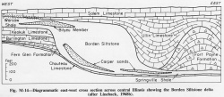
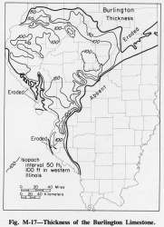
The Burlington extends from Henderson County in the northwest across a roughly triangular area southward to Jackson County and eastward to Iroquois County (fig. M-17). Good outcrops are found in the Mississippi River bluffs from Quincy, Adams County, to near Alton, Madison County (Collinson, 1964). In the vicinity of Quincy the lower 25 feet is relatively pure and is quarried as the "Quincy Lime." The formation is commonly 100-150 feet thick, but it is as much as 200 feet thick in western Christian County. It terminates sharply to the east where overlapped by the Borden Siltstone (fig. M-14).
Lithology
In the northwestern part of its extent the Burlington consists largely of very pure, coarsely crystalline, light gray limestone in medium to thick beds. It contains a few beds of fine-grained, brownish gray, dolomitic limestone. Beds and nodular masses of light gray or white chert are common, especially in the middle and upper parts of the formation. Some beds are glauconitic. Chert in some places forms as much as 50 percent of the formation, but the chert is exceedingly lenticular and the amounts vary greatly (Rubey , 1952). In the southern area the Burlington and the overlying Keokuk can be distinguished only by their fossils and are generally referred to as the Burlington-Keokuk Limestone.
Core(s)
Photograph(s)
Contacts
Well log characteristics
Fossils
In the northwestern part of its extent, large crinoid stems are abundant, and many beds are almost entirely crinoidal debris. The top of the Burlington is marked throughout a wide area by a bed 2-10 inches thick that contains many fish teeth and spines. Farther south the Burlington becomes more cherty, the crystalline limestone beds are few and fine-grained beds more common, and fossils are much less abundant. Among the common fossils restricted to the Burlington are Cryptoblastus melo, Globoblastus norwoodi, Dictyoclostus burlingtonensis, Rhipidomella burlingtonensis, Stenocisma bisinuata, Spirifer grimesi, S. forbesi, and Spiriferella plena (Weller and Sutton, 1940). Many crinoids have been described. The lower part of the Burlington Formation is in the conodont Bactrognathus--Polygnathus communis Zone, and the upper half is in the conodont Bactrognathus--Taphrognathus Zone (Collinson et al., 1971).
Age and correlation
Environments of deposition
The Burlington and the overlying Keokuk represent a shallow-water, largely clastic, carbonate sediment that was deposited on the western flank of the Illinois Basin while the Borden delta was expanding into the basin from the northeast.
Economic importance
Remarks
References
COLLINSON, CHARLES, 1964, Western Illinois: 28th Annual Tri-State Field Conference, Quincy, Illinois, Illinois State Geological Survey Guidebook Series 6, 30 p.
COLLINSON, CHARLES, C. B. REXROAD, and T. L. THOMPSON, 1971, Conodont zonation of the North American Mississippian: Geological Society of America Memoir 127, p. 353-395; Illinois State Geological Survey Reprint 1972-A.
HALL, JAMES, 1857, Observations upon the Carboniferous limestones of the Mississippi Valley (abstract): American Journal of Science, v. 23, p. 187-203.
OWEN, D. D., 1852, Report of a geological survey of Wisconsin, Iowa, and Minnesota and incidentally of a portion of Nebraska Territory: Philadelphia, 638 p.
RUBEY, W. W., 1952, Geology and mineral resources of the Hardin and Brussels Quadrangles: USGS Professional Paper 218, 179 p.
VAN TUYL, F. M., 1925, Stratigraphy of the Mississippian formations of Iowa: Iowa Geological Survey, v. 30, p. 33-349.
WELLER, J. M., and A. H. SUTTON, 1940, Mississippian border of Eastern Interior Basin: American Association of Petroleum Geologists Bulletin, v. 24, p. 765-858; Illinois State Geological Survey Report of Investigations 62.
ISGS Codes
| Stratigraphic Code | Geo Unit Designation |
|---|---|

