Search results
Jump to navigation
Jump to search
Page title matches
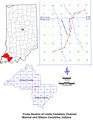
File:C605-Plate 6 - Leslie Cemetery Channel Xsec map.jpg {{Galatia Channel Image |File name=Plate 6 - Leslie Cemetery Channel Xsec map.jpg(1,786 × 2,300 (540 KB)) - 20:12, 10 July 2020

Page text matches
- ==Leslie Cemetery Channel== ...6]] and [[:File:C605-Plate 6 - Leslie Cemetery Channel Xsec map.jpg|Plate 6 Map Overview]]) has been constructed using borehole data.10 KB (1,463 words) - 19:24, 23 August 2023
- ==Effingham Channel== ...worgy, J.D., and M.H. Bargh, 1984, Coal resources of Illinois, Herrin (No. 6) Coal: Illinois State Geological Survey, 1 map sheet, 1:500,000.</ref>, and7 KB (979 words) - 19:20, 23 August 2023
- ...line-block;"> [[File:C605-Figure-04.jpg|thumb|left|500px|{{File:C605-Figure-04.jpg}}]]</li> ...a in Saline County, Illinois, which is situated directly above the Galatia channel.13 KB (1,882 words) - 20:50, 23 August 2023