Search results
Jump to navigation
Jump to search
Page title matches
File:Figure D-3E.jpg (1,599 × 2,000 (797 KB)) - 18:33, 4 April 2016
File:Figure D-4.jpg (2,253 × 1,605 (408 KB)) - 19:56, 1 April 2016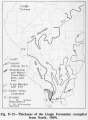
File:Figure D-15.jpg (1,076 × 1,466 (211 KB)) - 20:11, 1 April 2016
File:Figure D-5.jpg (3,349 × 2,143 (779 KB)) - 19:57, 1 April 2016
File:Figure D-16.jpg (1,064 × 1,615 (273 KB)) - 20:12, 1 April 2016
File:Figure D-6.jpg (2,105 × 3,295 (1.56 MB)) - 19:58, 1 April 2016
File:Figure D-17.jpg (1,084 × 1,643 (252 KB)) - 20:13, 1 April 2016
File:Figure D-7.jpg (1,092 × 2,057 (525 KB)) - 19:59, 1 April 2016
File:Figure D-18.jpg (1,046 × 1,600 (283 KB)) - 20:15, 1 April 2016
File:Figure D-8.jpg (1,060 × 1,089 (245 KB)) - 20:00, 1 April 2016
File:Figure D-19.jpg (1,080 × 1,084 (194 KB)) - 20:17, 1 April 2016
File:Figure D-9.jpg (1,100 × 1,227 (211 KB)) - 20:03, 1 April 2016
File:Figure D-20.jpg (1,076 × 795 (152 KB)) - 20:17, 1 April 2016
File:Figure D-10.jpg (1,100 × 2,018 (318 KB)) - 20:04, 1 April 2016
File:Figure D-3A.jpg (2,000 × 1,178 (1.04 MB)) - 18:21, 4 April 2016
File:Figure D-11.jpg (1,118 × 3,257 (428 KB)) - 20:05, 1 April 2016
File:Figure D-3B.jpg (2,000 × 1,610 (690 KB)) - 18:22, 4 April 2016
File:Figure D-12.jpg (1,060 × 1,114 (249 KB)) - 20:07, 1 April 2016
File:Figure D-3C.jpg (2,000 × 1,488 (601 KB)) - 18:29, 4 April 2016
File:Figure D-1.jpg (1,873 × 3,304 (777 KB)) - 19:51, 1 April 2016
File:Figure D-13.jpg (1,068 × 1,278 (291 KB)) - 20:08, 1 April 2016
File:Figure D-3D.jpg (1,344 × 2,000 (732 KB)) - 18:31, 4 April 2016
File:Figure D-2.jpg (2,239 × 2,490 (546 KB)) - 19:52, 1 April 2016
File:Figure D-14.jpg (1,048 × 1,428 (232 KB)) - 20:09, 1 April 2016


Page text matches
- Figure D-3A.jpg|{{file:Figure D-3A.jpg}} Figure D-3B.jpg|{{file:Figure D-3B.jpg}}4 KB (626 words) - 20:53, 5 January 2017
- Figure D-3A.jpg|{{file:Figure D-3A.jpg}} Figure D-3B.jpg|{{file:Figure D-3B.jpg}}5 KB (698 words) - 21:35, 6 January 2017
File:C605-Figure-26.jpg |File name=C605-Figure-26.jpg |image_no=Figure 26(1,573 × 1,782 (285 KB)) - 13:51, 23 August 2023
File:C605-Figure-27.jpg |File name=C605-Figure-27.jpg |image_no=Figure 27(1,418 × 1,307 (196 KB)) - 15:59, 17 August 2023- Figure D-3A.jpg|{{file:Figure D-3A.jpg}} Figure D-3B.jpg|{{file:Figure D-3B.jpg}}9 KB (1,405 words) - 20:41, 5 January 2017
File:Penn carbondale 4-76.jpg |Caption=Figure 4-76. Hand specimen of “blue band.” Photograph 2008 by Scott D. Elrick(2,401 × 1,923 (2.04 MB)) - 21:28, 4 January 2021
File:C605-Figure-37.jpg |File name=C605-Figure-37.jpg |image_no=Figure 37(1,535 × 1,872 (579 KB)) - 19:29, 23 August 2023- Figure D-3A.jpg|{{file:Figure D-3A.jpg}} Figure D-3B.jpg|{{file:Figure D-3B.jpg}}10 KB (1,478 words) - 17:18, 11 January 2017
- Figure P-9.jpg|{{file:Figure P-9.jpg}} Figure P-3A.jpg|{{file:Figure P-3A.jpg}}7 KB (1,108 words) - 21:46, 27 January 2017
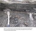
File:Penn carbondale 4-77.jpg |Caption=Figure 4-77. The “blue band” at a site where the Herrin Coal is reduced to th(2,401 × 2,041 (4.22 MB)) - 21:29, 4 January 2021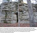
File:Penn caseyville 2-8.jpg Figure 2-8. Photograph of the Pounds Sandstone in Garden of the Gods State Park (S(2,201 × 2,002 (4.3 MB)) - 21:37, 24 November 2020- The Danville (Figures [[:File:C605-Figure-02.jpg|2]] and [[:File:C605-Figure-40.jpg|40]]) is the next major coal bed above the Baker. It is the youngest ...style="display: inline-block;">[[File:C605-Figure-02.jpg|500px|{{File:C605-Figure-02.jpg}}|thumb]]</li>3 KB (494 words) - 15:11, 23 August 2023
- Figure D-6.jpg|{{file:Figure D-6.jpg}}2 KB (341 words) - 21:50, 6 January 2017
- ...nklin, Hamilton, Saline, and Gallatin Counties ([[:File:C605-Figure-08.jpg|Figure 8]]). Widths are in the range of 0.6 to 1.9 mi (1 to 3 km). Portions appear ...style="display: inline-block;">[[File:C605-Figure-08.jpg|500px|{{File:C605-Figure-08.jpg}}|thumb]]</li>3 KB (493 words) - 19:38, 23 August 2023
- Figure D-3C.jpg|{{file:Figure D-3C.jpg}} Figure D-3D.jpg|{{file:Figure D-3D.jpg}}6 KB (824 words) - 21:39, 6 January 2017
- Figure D-3C.jpg|{{file:Figure D-3C.jpg}}4 KB (561 words) - 22:03, 6 January 2017
- Figure P-13.jpg|{{file:Figure P-13.jpg}}3 KB (397 words) - 15:56, 25 January 2017
- Figure 14.jpg|{{file:Figure 14.jpg}} Figure P-3D.jpg|{{file:Figure P-3D.jpg}}3 KB (482 words) - 22:16, 19 January 2017
- Figure D-3C.jpg|{{file:Figure D-3C.jpg}} Figure D-3D.jpg|{{file:Figure D-3D.jpg}}6 KB (895 words) - 17:24, 11 January 2017
- Figure D-3B.jpg|{{file:Figure D-3B.jpg}}4 KB (597 words) - 21:23, 9 January 2017
- ...e areas where the Springfield Coal is absent in Knox County. Eggert (1982, figure 2)<ref>Eggert, D.L., 1982, A fluvial channel contemporaneous with depositio ...mi (15 km) north of Oaktown in Sullivan County ([[:File:C605-Figure-29.jpg|Figure 29]]). As in the Oaktown Mine, shale laminae contain abundant fossil plants6 KB (931 words) - 19:16, 23 August 2023
- Figure D-3A.jpg|{{file:Figure D-3A.jpg}}5 KB (722 words) - 17:33, 9 January 2017
- Figure D-3C.jpg|{{file:Figure D-3C.jpg}}5 KB (632 words) - 17:46, 11 January 2017
- Figure D-6.jpg|{{file:Figure D-6.jpg}}3 KB (425 words) - 17:33, 11 January 2017
- Figure M-1B.jpg|{{file:Figure M-1B.jpg}} Figure M-1D.jpg|{{file:Figure M-1D.jpg}}3 KB (473 words) - 15:25, 18 January 2017
- ...shown in figure 6, and the spatial relations are shown diagrammatically in figure 8.2 KB (299 words) - 20:56, 12 January 2017
- Figure P-3A.jpg|{{file:Figure P-3A.jpg}} Figure P-3B.jpg|{{file:Figure P-3B.jpg}}24 KB (3,468 words) - 22:19, 19 January 2017
- Figure P-3A.jpg|{{file:Figure P-3A.jpg}} Figure P-3B.jpg|{{file:Figure P-3B.jpg}}24 KB (3,468 words) - 16:01, 20 January 2017
- ...lt or overlying beds. Its spatial relations are shown diagrammatically in figure 8. The geographic distribution of the member is shown in figure 6.2 KB (318 words) - 22:21, 3 January 2017
- the idealized sequence shown in figure P-7 is rarely complete, the units that are present have the same relative p Figure P-3A.jpg|{{file:Figure P-3A.jpg}}24 KB (3,539 words) - 16:05, 20 January 2017
- ...along a paleochannel that was partly contemporaneous with peat formation (Figure 44). Friedman (1960)<ref>Friedman, S.A., 1960, Channel-fill sandstones in t ...style="display: inline-block;">[[File:C605-Figure-44.jpg|500px|{{File:C605-Figure-44.jpg}}|thumb]]</li>5 KB (707 words) - 20:13, 23 August 2023
- Figure K-1A.jpg|{{file:Figure K-1A.jpg}} Figure K-1B.jpg|{{file:Figure K-1B.jpg}}9 KB (1,278 words) - 18:06, 21 November 2016
- Figure P-2.jpg|{{file:Figure P-2.jpg}}3 KB (399 words) - 18:34, 27 January 2017
- Figure 14.jpg|{{file:Figure 14.jpg}} Figure P-3D.jpg|{{file:Figure P-3D.jpg}}4 KB (561 words) - 22:48, 19 January 2017
- Figure D-3A.jpg|{{file:Figure D-3A.jpg}}6 KB (817 words) - 19:34, 22 October 2019
- Figure P-13.jpg|{{file:Figure P-13.jpg}}4 KB (474 words) - 16:56, 25 January 2017
- Figure P-2.jpg|{{file:Figure P-2.jpg}}3 KB (460 words) - 21:16, 27 January 2017
- ...the Winnebago to adjacent stratigraphic units is shown diagrammatically in figure 8. ...ic distribution of the formation at the surface is indicated on the map in figure 6.5 KB (697 words) - 20:55, 12 January 2017
- Figure K-1A.jpg|{{file:Figure K-1A.jpg}} Figure K-1B.jpg|{{file:Figure K-1B.jpg}}9 KB (1,353 words) - 16:29, 11 January 2017
- Figure M-1B.jpg|{{file:Figure M-1B.jpg}} Figure M-1D.jpg|{{file:Figure M-1D.jpg}}4 KB (560 words) - 15:25, 22 October 2019
- ...in figure 6, and its spatial relationship is indicated diagrammatically in figure 7.5 KB (773 words) - 22:14, 3 January 2017
- ...shown in figure 6, and the spatial relations are shown diagrammatically in figure 8.3 KB (349 words) - 21:10, 12 January 2017
- Figure D-3B.jpg|{{file:Figure D-3B.jpg}}6 KB (837 words) - 21:25, 22 October 2019
- ...lt or overlying beds. Its spatial relations are shown diagrammatically in figure 8. The geographic distribution of the member is shown in figure 6.3 KB (385 words) - 20:43, 12 January 2017
- Figure C-1C.jpg|{{file:Figure C-1C.jpg}}4 KB (541 words) - 21:00, 28 November 2016
- Figure S-2A.jpg|{{file:Figure S-2A.jpg}} Figure S-2B.jpg|{{file:Figure S-2B.jpg}}7 KB (1,052 words) - 20:03, 4 January 2017
- Figure O-2A.jpg|{{file:Figure O-2A.jpg}}5 KB (746 words) - 16:01, 21 December 2016
- ...Shale, which ranges up to 34 m (112 ft) thick ([[:File:C605-Figure-41.jpg|Figure 41]]). Low-sulfur Colchester Coal is known from only two mines among the hu ...style="display: inline-block;">[[File:C605-Figure-40.jpg|500px|{{File:C605-Figure-40.jpg}}|thumb]]</li>7 KB (1,027 words) - 15:08, 23 August 2023
- The geographic extent of the Winslow Till Member is shown in figure 6. It is generally less than 20 feet thick.2 KB (347 words) - 22:28, 3 January 2017
- ...ay: inline-block;"> [[File:C605-Figure-04.jpg|thumb|left|500px|{{File:C605-Figure-04.jpg}}]]</li> ...40.0 m), making the unit 40.6ft (12.4 m) thick ([[:File:C605-Figure-06.jpg|Figure 6]] and [[Galatia Channel:Appendix#D. Type Section of the Galatia Member (N13 KB (1,882 words) - 20:50, 23 August 2023


