Argyle Till Member
Lithostratigraphy: Winnebago Formation >>Argyle Till Member
Chronostratigraphy: Cenozoic Erathem >>Quaternary System >>Pleistocene Series
Primary source
Willman, H. B., and John C. Frye, 1970, Pleistocene Stratigraphy of Illinois: Illinois State Geological Survey Bulletin 94, 204 p.
Contributing author(s)
H. B. Willman and John C. Frye
Name
Original description
Informally named the Argyle till (Frye et al., 1969, p. 26).
Derivation
Named for Argyle, Winnebago County, from exposures in the vicinity of Argyle on the Winnebago County line.
Other names
History/background
Type section
Type location
Its type section is the Rock Valley College Section 5 miles southwest of Argyle, SW NW SW Sec. 10, T. 44 N., R. 2 E.
Type author(s)
Type status
Reference section
Reference location
Reference author(s)
Reference status
Stratigraphic relationships
The Argyle is bounded at the top by its contact with the Plano Silt Member or overlying beds, and its basal contact is with unnamed silts in the lower part of the Winnebago Formation or older deposits.
Extent and thickness
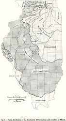
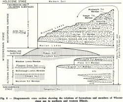
The geographic distribution as a surface till is shown in figure 6, and the spatial relations are shown diagrammatically in figure 8.
Lithology
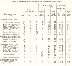
The till is exceptionally sandy, as shown in table 2, and pinkish tan or salmon in color. Its composition has been described by the Greenway School cores and the Beaverton, Byron West, Dixon Northwest, Grand Detour, and Meridian Road No. 3 Sections (Frye et al., 1969).
Core(s)
Photograph(s)
Contacts
Well log characteristics
Fossils
Age and correlation
The Argyle Till Member is in the midpart of the Altonian Substage of the Wisconsinan Stage.
Environments of deposition
Economic importance
Remarks
References
FRYE, J. C., H. D. GLASS, J. P. KEMPTON, and H. B. WILLMAN, 1969, Glacial Tills of Northwestern Illinois: Illinois State Geological Survey Circular 437, 47 p.
ISGS Codes
| Stratigraphic Code | Geo Unit Designation |
|---|---|


