File:C605-Figure-01.jpg
Jump to navigation
Jump to search


Size of this preview: 426 × 600 pixels. Other resolution: 1,704 × 2,400 pixels.
Original file (1,704 × 2,400 pixels, file size: 727 KB, MIME type: image/jpeg)
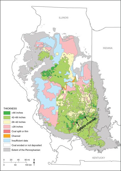
Figure 1 Map of the Illinois Basin showing the extent of Pennsylvanian rocks, thickness of the Springfield Coal, and channels interrupting the coal. From Finley et al. (2005)[1]. Straight lines separating polygons are artifacts of mapping protocol in original.
- ↑ Finley, R., and Midwest Geological Sequestration Consortium, 2005, An assessment of geological carbon sequestration options in the Illinois Basin: Illinois State Geological Survey, final report to U.S. Department of Energy, contract DE-FC26-03NT41994, 477 p.
File history
Click on a date/time to view the file as it appeared at that time.
| Date/Time | Thumbnail | Dimensions | User | Comment | |
|---|---|---|---|---|---|
| current | ★ Approved revision 20:59, 17 July 2020 | | 1,704 × 2,400 (727 KB) | Alan.Myers (talk | contribs) |
You cannot overwrite this file.
File usage
The following 3 pages use this file: