File:104-Figure 10.jpg
Jump to navigation
Jump to search


Size of this preview: 434 × 599 pixels. Other resolution: 1,449 × 2,000 pixels.
Original file (1,449 × 2,000 pixels, file size: 536 KB, MIME type: image/jpeg)
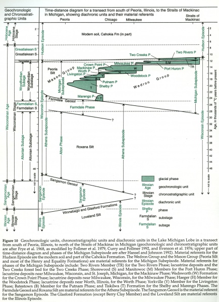
Figure 10 -- Geochronological units, chronostratigraphic units and diachronic units in the Lake Michigan Lobe in a transect from south of Peoria, Illinois, to north of the Straits of Mackinac in Michigan (geochronologic and chronostratigraphic units are after Frye et al. 1968, as modified by Follmer et al. 1979, Curry and Follmer 1992, and Evenson et al. 1976; upper part of time-distance diagram and phases of the Michigan Subepisode are after Hansel and Johnson 1992).
File history
Click on a date/time to view the file as it appeared at that time.
| Date/Time | Thumbnail | Dimensions | User | Comment | |
|---|---|---|---|---|---|
| current | ★ Approved revision 16:31, 19 April 2016 |  | 1,449 × 2,000 (536 KB) | Illex-gron (talk | contribs) | Figure 10 -- Geochronological units, chronostratigraphic units and diachronic units in the Lake Michigan Lobe in a transect from south of Peoria, Illinois, to north of the Straits of Mackinac in Michigan (geochronologic and chronostratigraphic units ar... |
You cannot overwrite this file.
File usage
The following 34 pages use this file:
- Batestown Member
- Beverly Tongue
- Delavan Member
- Haeger Member
- Kewaunee Formation
- Lemont Formation
- Manitowoc Member
- Peddicord Tongue
- Piatt Member
- Robein Member
- Roxana Silt
- Shorewood Member
- Tiskilwa Formation
- Two Rivers Member
- Wadsworth Formation
- Wedron Group
- Yorkville Member
- Historical:Batestown Member
- Historical:Beverly Tongue
- Historical:Delavan Member
- Historical:Haeger Member
- Historical:Kewaunee Formation
- Historical:Lemont Formation
- Historical:Manitowoc Member
- Historical:Peddicord Tongue
- Historical:Piatt Member
- Historical:Robein Member
- Historical:Roxana Silt
- Historical:Shorewood Member
- Historical:Tiskilwa Formation
- Historical:Two Rivers Member
- Historical:Wadsworth Formation
- Historical:Wedron Group
- Historical:Yorkville Member